Property Record
4312 New Holland Rd, Mohnton, PA 19540

NEARBY LISTINGS FOR SALE OR LEASE
-
-
View all Mohnton listings for sale on LoopNet.com
Property Detail
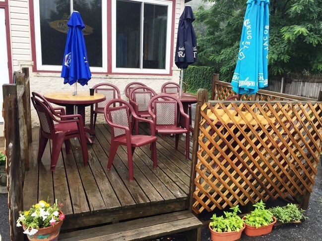
4312 New Holland Rd
Restaurantbuilding
Berks
X
Pennsylvania
42071C0230F
0.63 AC
2025
Berks County
2025
Philadelphia
011702
Reading, PA
6,820 SF
34-4393-01-18-3200
DEMOGRAPHICS near 4312 New Holland Rd
1 Mile
3 Mile
5 Mile
2024 Total Population
1,361
11,085
55,719
2029 Population
1,380
11,136
55,844
Pop Growth 2024-2029
+ 1.40%
+ 0.46%
+ 0.22%
Average Age
45
44
42
2024 Total Households
534
4,375
22,070
HH Growth 2024-2029
+ 1.50%
+ 0.43%
+ 0.22%
Median Household Inc
$122,169
$92,754
$85,929
Avg Household Size
2.50
2.50
2.50
2024 Avg HH Vehicles
3.00
2.00
2.00
Median Home Value
$315,420
$279,934
$239,083
Median Year Built
1985
1978
1975
Nearby Places
Map Layers
Map Styles
 Street
 Aerial
- Restaurants
- Banks
- Shops
- Fitness
- Groceries
PUBLIC TRANSPORTATION
AIRPORT
Lehigh Valley International
DRIVE
WALK
Distance
Lehigh Valley International
73 min
47.8 mi
Freight Ports
Port of Wilmington, RI
DRIVE
WALK
Distance
Port of Wilmington, RI
85 min
55.6 mi
SALE & LEASE HISTORY
LISTING DATE
SALE/LEASE

Sep 23, 2020
For Sale
Sep 16, 2019
For Sale
Oct 11, 2018
For Sale
Oct 06, 2016
For Sale
Nov 07, 2016
For Sale
Jul 28, 2017
For Sale
Aug 26, 2019
For Sale
Apr 04, 2019
For Lease
Nearby Properties
Address
Land Use
TOTAL SIZE
Lot Size
Zoning
Address
Land Use
TOTAL SIZE
Lot Size
Zoning
120,390 SF
12.65 AC
Address
Land Use
TOTAL SIZE
Lot Size
Zoning
16,640 SF
9.90 AC
Address
Land Use
TOTAL SIZE
Lot Size
Zoning
56,400 SF
12.06 AC
Address
Land Use
TOTAL SIZE
Lot Size
Zoning
19,901 SF
126.15 AC
Address
Land Use
TOTAL SIZE
Lot Size
Zoning
6,624 SF
103.60 AC
AG
Address
Land Use
TOTAL SIZE
Lot Size
Zoning
5,430 SF
106.50 AC
AG
Address
Land Use
TOTAL SIZE
Lot Size
Zoning
11,818 SF
49.40 AC
Address
Land Use
TOTAL SIZE
Lot Size
Zoning
22,672 SF
4.57 AC
Address
Land Use
TOTAL SIZE
Lot Size
Zoning
28,140 SF
208.09 AC
Address
Land Use
TOTAL SIZE
Lot Size
Zoning
6,154 SF
66.85 AC
AG
Address
Land Use
TOTAL SIZE
Lot Size
Zoning
79,142 SF
10.38 AC
Address
Land Use
TOTAL SIZE
Lot Size
Zoning
3,650 SF
85.90 AC
FR
Address
Land Use
TOTAL SIZE
Lot Size
Zoning
7,144 SF
48.70 AC
AG
Address
Land Use
TOTAL SIZE
Lot Size
Zoning
4,472 SF
61.20 AC
AG
Address
Land Use
TOTAL SIZE
Lot Size
Zoning
4,510 SF
48.30 AC
AG
Address
Land Use
TOTAL SIZE
Lot Size
Zoning
60,638 SF
7.21 AC
Address
Land Use
TOTAL SIZE
Lot Size
Zoning
3,336 SF
53.45 AC
AG
Address
Land Use
TOTAL SIZE
Lot Size
Zoning
14,880 SF
4.49 AC
Address
Land Use
TOTAL SIZE
Lot Size
Zoning
3,872 SF
61.10 AC
AG
Address
Land Use
TOTAL SIZE
Lot Size
Zoning
20,344 SF
9.70 AC
AG
Address
Land Use
TOTAL SIZE
Lot Size
Zoning
2,896 SF
32.70 AC
AG
Address
Land Use
TOTAL SIZE
Lot Size
Zoning
4,044 SF
40.80 AC
AG
Address
Land Use
TOTAL SIZE
Lot Size
Zoning
5,040 SF
20.40 AC
AG
Address
Land Use
TOTAL SIZE
Lot Size
Zoning
29,546 SF
3.51 AC
Address
Land Use
TOTAL SIZE
Lot Size
Zoning
16,250 SF
2.87 AC
Address
Land Use
TOTAL SIZE
Lot Size
Zoning
5,522 SF
26.86 AC
AG
Address
Land Use
TOTAL SIZE
Lot Size
Zoning
3,309 SF
52.10 AC
AG
Address
Land Use
TOTAL SIZE
Lot Size
Zoning
6,914 SF
19.50 AC
AG
Address
Land Use
TOTAL SIZE
Lot Size
Zoning
Address
Land Use
TOTAL SIZE
Lot Size
Zoning
6,208 SF
17.50 AC
FR
The World's #1 Commercial Real Estate Marketplace
Connect with us
© 2026 CoStar Group
The information above has been obtained from sources believed reliable. While we do not doubt its accuracy we have not verified it and make no guarantee, warranty or representation about it. It is your responsibility to independently confirm its accuracy and completeness. Any projections, opinions, assumptions, or estimates used are for example only and do not represent the current or future performance of the property. The value of this transaction to you depends on tax and other factors which should be evaluated by your tax, financial, and legal advisors. You and your advisors should conduct a careful, independent investigation of the property to determine to your satisfaction the suitability of the property for your needs.