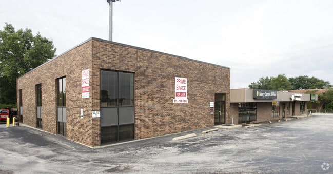
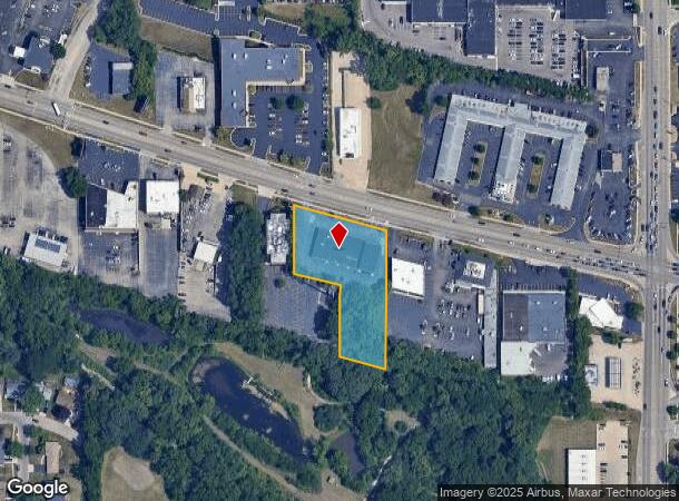
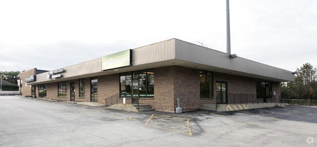
Property Record
4315 E State St, Rockford, IL 61108
NEARBY LISTINGS FOR SALE OR LEASE
Property Detail
4315 E State St
12-29-129-015
BEG AT A PT ON THE SLY LN STATE ST 660FT WLY OF PT 60 FT W OF E LN NW1/4 &50 PERP S OF C/L STATE ST SLY 360.55 FT NW 125 FT N 186.21 FT NW 125 FT NLY
Commercialnec
Winnebago
X
Illinois
17201C0268E
1.48 AC
2024
I-39 Corr/Winnebago Cnty
2024
Chicago
001500
Rockford, IL
14,556 SF
DEMOGRAPHICS near 4315 E State St
1 Mile
3 Mile
5 Mile
2024 Total Population
10,582
85,338
180,988
2029 Population
10,496
84,145
178,981
Pop Growth 2024-2029
(0.81%)
(1.40%)
(1.11%)
Average Age
39
40
40
2024 Total Households
4,182
34,915
74,292
HH Growth 2024-2029
(0.81%)
(1.41%)
(1.16%)
Median Household Inc
$53,750
$52,637
$48,920
Avg Household Size
2.40
2.30
2.30
2024 Avg HH Vehicles
2.00
2.00
2.00
Median Home Value
$99,071
$125,567
$123,890
Median Year Built
1963
1962
1964
Nearby Places
Map Layers
Map Styles
 Street
 Aerial
- Restaurants
- Banks
- Shops
- Fitness
- Groceries
PUBLIC TRANSPORTATION
AIRPORT
Chicago/Rockford International
DRIVE
WALK
Distance
Chicago/Rockford International
21 min
10.7 mi
SALE & LEASE HISTORY
LISTING DATE
SALE/LEASE

Sep 25, 2016
For Lease
Nov 09, 2018
For Lease
Nearby Properties
Address
Land Use
TOTAL SIZE
Lot Size
Zoning
Address
Land Use
TOTAL SIZE
Lot Size
Zoning
302,569 SF
24.58 AC
C2
Address
Land Use
TOTAL SIZE
Lot Size
Zoning
920,723 SF
82.07 AC
Address
Land Use
TOTAL SIZE
Lot Size
Zoning
169,198 SF
14 AC
C3
Address
Land Use
TOTAL SIZE
Lot Size
Zoning
138,658 SF
12.91 AC
C2
Address
Land Use
TOTAL SIZE
Lot Size
Zoning
134,779 SF
9.93 AC
C2
Address
Land Use
TOTAL SIZE
Lot Size
Zoning
217,520 SF
13.82 AC
C3
Address
Land Use
TOTAL SIZE
Lot Size
Zoning
119,560 SF
2.89 AC
R1
Address
Land Use
TOTAL SIZE
Lot Size
Zoning
79,055 SF
10.89 AC
R4
Address
Land Use
TOTAL SIZE
Lot Size
Zoning
110,218 SF
8.12 AC
C2
Address
Land Use
TOTAL SIZE
Lot Size
Zoning
96,130 SF
12.47 AC
R2
Address
Land Use
TOTAL SIZE
Lot Size
Zoning
73,031 SF
10.23 AC
C1
Address
Land Use
TOTAL SIZE
Lot Size
Zoning
117,360 SF
1.52 AC
R4
Address
Land Use
TOTAL SIZE
Lot Size
Zoning
141,752 SF
12.10 AC
C2
Address
Land Use
TOTAL SIZE
Lot Size
Zoning
128,736 SF
14.64 AC
C2
Address
Land Use
TOTAL SIZE
Lot Size
Zoning
147,900 SF
7.78 AC
Address
Land Use
TOTAL SIZE
Lot Size
Zoning
142,140 SF
13.44 AC
C2
Address
Land Use
TOTAL SIZE
Lot Size
Zoning
71,799 SF
4.51 AC
C1
Address
Land Use
TOTAL SIZE
Lot Size
Zoning
84,569 SF
4 AC
C3
Address
Land Use
TOTAL SIZE
Lot Size
Zoning
89,350 SF
9.17 AC
C2
Address
Land Use
TOTAL SIZE
Lot Size
Zoning
77,718 SF
11.12 AC
C2
Address
Land Use
TOTAL SIZE
Lot Size
Zoning
49,832 SF
5.62 AC
C2
Address
Land Use
TOTAL SIZE
Lot Size
Zoning
138,746 SF
11.04 AC
C3
Address
Land Use
TOTAL SIZE
Lot Size
Zoning
63,016 SF
5.48 AC
C1
Address
Land Use
TOTAL SIZE
Lot Size
Zoning
199,330 SF
15.02 AC
CG
Address
Land Use
TOTAL SIZE
Lot Size
Zoning
32,027 SF
117.18 AC
AG
Address
Land Use
TOTAL SIZE
Lot Size
Zoning
79,318 SF
1.55 AC
C4
Address
Land Use
TOTAL SIZE
Lot Size
Zoning
136,530 SF
4 AC
R4
Address
Land Use
TOTAL SIZE
Lot Size
Zoning
79,700 SF
7.15 AC
C2
Address
Land Use
TOTAL SIZE
Lot Size
Zoning
123,414 SF
8.86 AC
C3
Address
Land Use
TOTAL SIZE
Lot Size
Zoning
60,479 SF
117 AC
R1
The World's #1 Commercial Real Estate Marketplace
Connect with us
© 2026 CoStar Group
The information above has been obtained from sources believed reliable. While we do not doubt its accuracy we have not verified it and make no guarantee, warranty or representation about it. It is your responsibility to independently confirm its accuracy and completeness. Any projections, opinions, assumptions, or estimates used are for example only and do not represent the current or future performance of the property. The value of this transaction to you depends on tax and other factors which should be evaluated by your tax, financial, and legal advisors. You and your advisors should conduct a careful, independent investigation of the property to determine to your satisfaction the suitability of the property for your needs.