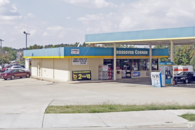
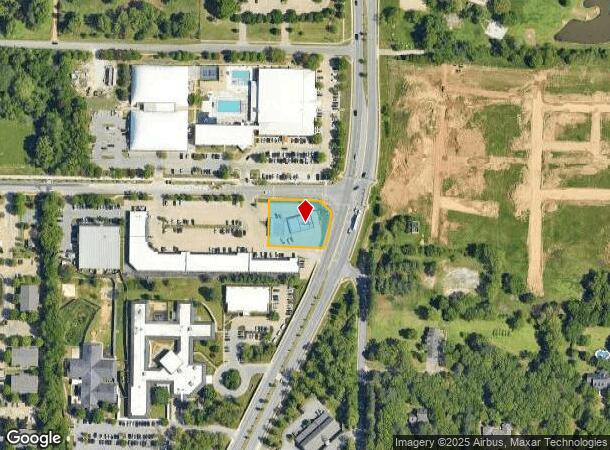
Property Record
4315 N Crossover Rd, Fayetteville, AR 72703

NEARBY LISTINGS FOR SALE OR LEASE
Property Detail
4315 N Crossover Rd
Fayetteville-Springdale-Rogers, AR-MO
Kee Corner Plaza S/D
765-19465-000
PART OF LOT 4
Conveniencestore
Washington
X
Arkansas
05143C0090G
4
2025
0.62 AC
2025
Greater Fayetteville
010114
Fayetteville/Springdale/Rogers
2,927 SF
DEMOGRAPHICS near 4315 N Crossover Rd
1 Mile
3 Mile
5 Mile
2024 Total Population
3,840
47,133
119,428
2029 Population
4,177
51,477
130,790
Pop Growth 2024-2029
+ 8.78%
+ 9.22%
+ 9.51%
Average Age
39
37
35
2024 Total Households
1,698
18,339
45,172
HH Growth 2024-2029
+ 9.19%
+ 9.42%
+ 9.71%
Median Household Inc
$74,611
$74,036
$61,071
Avg Household Size
2.10
2.50
2.50
2024 Avg HH Vehicles
2.00
2.00
2.00
Median Home Value
$294,867
$262,256
$253,445
Median Year Built
1997
1995
1992
Nearby Places
Map Layers
Map Styles
 Street
 Aerial
- Restaurants
- Banks
- Shops
- Fitness
- Groceries
PUBLIC TRANSPORTATION
AIRPORT
Northwest Arkansas Ntl
DRIVE
WALK
Distance
Northwest Arkansas Ntl
41 min
21.1 mi
Freight Ports
Tulsa Port of Inola
DRIVE
WALK
Distance
Tulsa Port of Inola
110 min
92.5 mi
SALE & LEASE HISTORY
LISTING DATE
SALE/LEASE

May 31, 2018
For Sale
Jun 30, 2021
For Sale
Jun 04, 2018
For Sale
Nearby Properties
Address
Land Use
TOTAL SIZE
Lot Size
Zoning
Address
Land Use
TOTAL SIZE
Lot Size
Zoning
167,116 SF
41.39 AC
I1
Address
Land Use
TOTAL SIZE
Lot Size
Zoning
153,698 SF
14.10 AC
C2
Address
Land Use
TOTAL SIZE
Lot Size
Zoning
481,800 SF
40 AC
Address
Land Use
TOTAL SIZE
Lot Size
Zoning
23,707 SF
15.45 AC
R2
Address
Land Use
TOTAL SIZE
Lot Size
Zoning
238,168 SF
Address
Land Use
TOTAL SIZE
Lot Size
Zoning
50,708 SF
1.69 AC
C2
Address
Land Use
TOTAL SIZE
Lot Size
Zoning
232,212 SF
10.31 AC
Address
Land Use
TOTAL SIZE
Lot Size
Zoning
305,272 SF
9.66 AC
R2
Address
Land Use
TOTAL SIZE
Lot Size
Zoning
567,022 SF
88.88 AC
C2
Address
Land Use
TOTAL SIZE
Lot Size
Zoning
6,798 SF
10.56 AC
Address
Land Use
TOTAL SIZE
Lot Size
Zoning
41,952 SF
19.26 AC
Address
Land Use
TOTAL SIZE
Lot Size
Zoning
19,805 SF
0.35 AC
R0
Address
Land Use
TOTAL SIZE
Lot Size
Zoning
178,014 SF
6.43 AC
Address
Land Use
TOTAL SIZE
Lot Size
Zoning
261,670 SF
16.72 AC
R2
Address
Land Use
TOTAL SIZE
Lot Size
Zoning
217,873 SF
24.10 AC
C2
Address
Land Use
TOTAL SIZE
Lot Size
Zoning
4,941 SF
10.87 AC
Address
Land Use
TOTAL SIZE
Lot Size
Zoning
134,342 SF
14.95 AC
Address
Land Use
TOTAL SIZE
Lot Size
Zoning
156,072 SF
12.43 AC
Address
Land Use
TOTAL SIZE
Lot Size
Zoning
56,672 SF
0.53 AC
R0
Address
Land Use
TOTAL SIZE
Lot Size
Zoning
64,659 SF
4.99 AC
R0
Address
Land Use
TOTAL SIZE
Lot Size
Zoning
71,336 SF
6.24 AC
Address
Land Use
TOTAL SIZE
Lot Size
Zoning
117,196 SF
9.74 AC
Address
Land Use
TOTAL SIZE
Lot Size
Zoning
66,120 SF
1.95 AC
Address
Land Use
TOTAL SIZE
Lot Size
Zoning
12,690 SF
1.72 AC
Address
Land Use
TOTAL SIZE
Lot Size
Zoning
72,162 SF
3.31 AC
Address
Land Use
TOTAL SIZE
Lot Size
Zoning
73,436 SF
16.01 AC
I1
Address
Land Use
TOTAL SIZE
Lot Size
Zoning
96,710 SF
Address
Land Use
TOTAL SIZE
Lot Size
Zoning
55,877 SF
6.43 AC
C2
Address
Land Use
TOTAL SIZE
Lot Size
Zoning
61,431 SF
1.62 AC
C2
Address
Land Use
TOTAL SIZE
Lot Size
Zoning
69,412 SF
8.81 AC
R0
The World's #1 Commercial Real Estate Marketplace
Connect with us
© 2025 CoStar Group
The information above has been obtained from sources believed reliable. While we do not doubt its accuracy we have not verified it and make no guarantee, warranty or representation about it. It is your responsibility to independently confirm its accuracy and completeness. Any projections, opinions, assumptions, or estimates used are for example only and do not represent the current or future performance of the property. The value of this transaction to you depends on tax and other factors which should be evaluated by your tax, financial, and legal advisors. You and your advisors should conduct a careful, independent investigation of the property to determine to your satisfaction the suitability of the property for your needs.