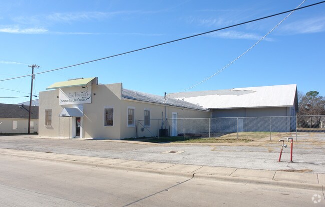
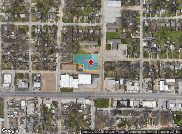
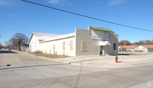
Property Record
4315 Ne Loraine St, Haltom City, TX 76117
NEARBY LISTINGS FOR SALE OR LEASE
Property Detail
4315 Ne Loraine St
Dallas-Fort Worth-Arlington, TX
Eastridge Subdivision
06013260
EASTRIDGE SUBDIVISION BLOCK 4 LOT 1R1
Commercialnec
Tarrant
X
Texas
48439C0195L
1
0
1.13 AC
2025
Meacham Fld/Fossil Cr
110102
Dallas/Ft Worth
8,200 SF
DEMOGRAPHICS near 4315 Ne Loraine St
1 Mile
3 Mile
5 Mile
2024 Total Population
14,935
73,965
248,972
2029 Population
15,609
78,104
263,945
Pop Growth 2024-2029
+ 4.51%
+ 5.60%
+ 6.01%
Average Age
35
36
36
2024 Total Households
4,549
24,872
89,575
HH Growth 2024-2029
+ 4.42%
+ 5.78%
+ 6.31%
Median Household Inc
$48,574
$51,924
$54,940
Avg Household Size
3.20
2.90
2.60
2024 Avg HH Vehicles
2.00
2.00
2.00
Median Home Value
$152,391
$174,485
$196,246
Median Year Built
1958
1963
1978
Nearby Places
Map Layers
Map Styles
 Street
 Aerial
- Restaurants
- Banks
- Shops
- Fitness
- Groceries
PUBLIC TRANSPORTATION
COMMUTER RAIL
Richland Hills (Trinity Railway Express - Dallas Area Rapid Transit (DART))
DRIVE
WALK
Distance
Richland Hills (Trinity Railway Express - Dallas Area Rapid Transit (DART))
9 min
4.9 mi
DRIVE
WALK
Distance
10 min
5.2 mi
AIRPORT
Dallas-Fort Worth International
DRIVE
WALK
Distance
Dallas-Fort Worth International
29 min
20.4 mi
Dallas Love Field
DRIVE
WALK
Distance
Dallas Love Field
40 min
29.0 mi
Nearby Properties
Address
Land Use
TOTAL SIZE
Lot Size
Zoning
Address
Land Use
TOTAL SIZE
Lot Size
Zoning
352,354 SF
17.02 AC
Address
Land Use
TOTAL SIZE
Lot Size
Zoning
699,246 SF
40.69 AC
Address
Land Use
TOTAL SIZE
Lot Size
Zoning
385,697 SF
15.94 AC
Address
Land Use
TOTAL SIZE
Lot Size
Zoning
810,978 SF
45.84 AC
Address
Land Use
TOTAL SIZE
Lot Size
Zoning
257,308 SF
8.13 AC
Address
Land Use
TOTAL SIZE
Lot Size
Zoning
697,140 SF
37.84 AC
Address
Land Use
TOTAL SIZE
Lot Size
Zoning
248,993 SF
15.40 AC
Address
Land Use
TOTAL SIZE
Lot Size
Zoning
293,972 SF
17.30 AC
Address
Land Use
TOTAL SIZE
Lot Size
Zoning
656,390 SF
33.33 AC
Address
Land Use
TOTAL SIZE
Lot Size
Zoning
566,816 SF
32.79 AC
Address
Land Use
TOTAL SIZE
Lot Size
Zoning
255,773 SF
12.48 AC
Address
Land Use
TOTAL SIZE
Lot Size
Zoning
459,540 SF
36.02 AC
Address
Land Use
TOTAL SIZE
Lot Size
Zoning
310,780 SF
4.38 AC
Address
Land Use
TOTAL SIZE
Lot Size
Zoning
221,946 SF
31.17 AC
Address
Land Use
TOTAL SIZE
Lot Size
Zoning
197,131 SF
43.78 AC
Address
Land Use
TOTAL SIZE
Lot Size
Zoning
540,414 SF
28.67 AC
Address
Land Use
TOTAL SIZE
Lot Size
Zoning
284,637 SF
2.62 AC
Address
Land Use
TOTAL SIZE
Lot Size
Zoning
427,908 SF
22.04 AC
Address
Land Use
TOTAL SIZE
Lot Size
Zoning
346,850 SF
27.38 AC
Address
Land Use
TOTAL SIZE
Lot Size
Zoning
764,254 SF
40.80 AC
Address
Land Use
TOTAL SIZE
Lot Size
Zoning
141,276 SF
12.04 AC
Address
Land Use
TOTAL SIZE
Lot Size
Zoning
125,838 SF
12.38 AC
Address
Land Use
TOTAL SIZE
Lot Size
Zoning
185,047 SF
10 AC
Address
Land Use
TOTAL SIZE
Lot Size
Zoning
131,500 SF
4.30 AC
Address
Land Use
TOTAL SIZE
Lot Size
Zoning
106,045 SF
9.64 AC
Address
Land Use
TOTAL SIZE
Lot Size
Zoning
93,586 SF
7.93 AC
Address
Land Use
TOTAL SIZE
Lot Size
Zoning
129,600 SF
3.73 AC
Address
Land Use
TOTAL SIZE
Lot Size
Zoning
146,000 SF
8.54 AC
Address
Land Use
TOTAL SIZE
Lot Size
Zoning
148,720 SF
8.04 AC
Address
Land Use
TOTAL SIZE
Lot Size
Zoning
93,380 SF
8.64 AC
The World's #1 Commercial Real Estate Marketplace
Connect with us
© 2025 CoStar Group
The information above has been obtained from sources believed reliable. While we do not doubt its accuracy we have not verified it and make no guarantee, warranty or representation about it. It is your responsibility to independently confirm its accuracy and completeness. Any projections, opinions, assumptions, or estimates used are for example only and do not represent the current or future performance of the property. The value of this transaction to you depends on tax and other factors which should be evaluated by your tax, financial, and legal advisors. You and your advisors should conduct a careful, independent investigation of the property to determine to your satisfaction the suitability of the property for your needs.