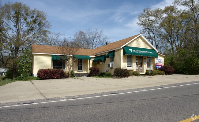
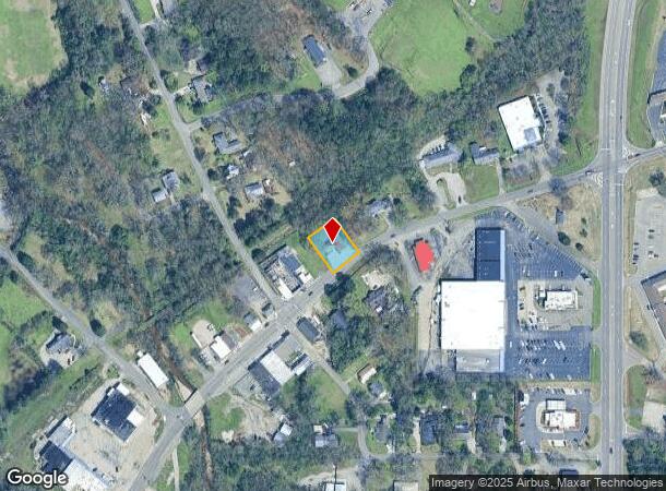
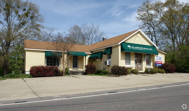
Property Record
4316 Main St, Pinson, AL 35126
NEARBY LISTINGS FOR SALE OR LEASE
-
-
View all Pinson listings for sale on LoopNet.com
Property Detail
4316 Main St
09-00-31-2-007-003.000
COM AT NE COR NW 1/4 TH S 365 FT TO SE LINE RR R/W TH SW ALONG SAID R/W 1010 FT TO POB TH CONT ALONG SAID R/W 100 FT TH SE 135 FT TH NE 100 FT TH NW 125 FT TO POB SECT 31 TWSP 15S RANGE 1W
Financialbuilding
Jefferson
AE
Alabama
01073C0233J
0.31 AC
2023
Fultondale
2024
Birmingham
011205
Birmingham-Hoover, AL
1,428 SF
DEMOGRAPHICS near 4316 Main St
1 Mile
3 Mile
5 Mile
2024 Total Population
1,421
21,616
61,511
2029 Population
1,376
21,156
60,256
Pop Growth 2024-2029
(3.17%)
(2.13%)
(2.04%)
Average Age
40
36
37
2024 Total Households
545
7,935
22,982
HH Growth 2024-2029
(3.30%)
(2.16%)
(2.09%)
Median Household Inc
$68,096
$54,192
$52,144
Avg Household Size
2.60
2.70
2.60
2024 Avg HH Vehicles
2.00
2.00
2.00
Median Home Value
$169,961
$155,207
$152,584
Median Year Built
1978
1980
1979
Nearby Places
Map Layers
Map Styles
 Street
 Aerial
- Restaurants
- Banks
- Shops
- Fitness
- Groceries
PUBLIC TRANSPORTATION
AIRPORT
Birmingham-Shuttlesworth International
DRIVE
WALK
Distance
Birmingham-Shuttlesworth International
23 min
14.0 mi
Nearby Properties
Address
Land Use
TOTAL SIZE
Lot Size
Zoning
Address
Land Use
TOTAL SIZE
Lot Size
Zoning
192,596 SF
13.79 AC
CR5
Address
Land Use
TOTAL SIZE
Lot Size
Zoning
531,808 SF
23.96 AC
I4&A
Address
Land Use
TOTAL SIZE
Lot Size
Zoning
502,302 SF
24.61 AC
I4&A
Address
Land Use
TOTAL SIZE
Lot Size
Zoning
117,342 SF
36 AC
I
Address
Land Use
TOTAL SIZE
Lot Size
Zoning
81,817 SF
9.30 AC
C1
Address
Land Use
TOTAL SIZE
Lot Size
Zoning
26,169 SF
71 AC
R2
Address
Land Use
TOTAL SIZE
Lot Size
Zoning
56,504 SF
2 AC
C1-C
Address
Land Use
TOTAL SIZE
Lot Size
Zoning
63,736 SF
11 AC
I
Address
Land Use
TOTAL SIZE
Lot Size
Zoning
113,175 SF
21.85 AC
I2
Address
Land Use
TOTAL SIZE
Lot Size
Zoning
61,472 SF
18.84 AC
INT-
Address
Land Use
TOTAL SIZE
Lot Size
Zoning
147,810 SF
13 AC
I4
Address
Land Use
TOTAL SIZE
Lot Size
Zoning
3.56 AC
CR6&
Address
Land Use
TOTAL SIZE
Lot Size
Zoning
329,728 SF
29.40 AC
I4&A
Address
Land Use
TOTAL SIZE
Lot Size
Zoning
58,816 SF
2.98 AC
C1
Address
Land Use
TOTAL SIZE
Lot Size
Zoning
109,646 SF
6.40 AC
Address
Land Use
TOTAL SIZE
Lot Size
Zoning
76,321 SF
9.26 AC
I-2
Address
Land Use
TOTAL SIZE
Lot Size
Zoning
40,535 SF
4 AC
INST
Address
Land Use
TOTAL SIZE
Lot Size
Zoning
43,064 SF
2.33 AC
CR5
Address
Land Use
TOTAL SIZE
Lot Size
Zoning
29,932 SF
12.40 AC
INST
Address
Land Use
TOTAL SIZE
Lot Size
Zoning
34,755 SF
1.28 AC
INST
Address
Land Use
TOTAL SIZE
Lot Size
Zoning
148,564 SF
11 AC
I2
Address
Land Use
TOTAL SIZE
Lot Size
Zoning
78,024 SF
10.90 AC
I-1
Address
Land Use
TOTAL SIZE
Lot Size
Zoning
78,112 SF
4.64 AC
R4
Address
Land Use
TOTAL SIZE
Lot Size
Zoning
28,648 SF
3.91 AC
I
Address
Land Use
TOTAL SIZE
Lot Size
Zoning
20,625 SF
5.30 AC
A1IN
Address
Land Use
TOTAL SIZE
Lot Size
Zoning
84,694 SF
6.86 AC
M4
Address
Land Use
TOTAL SIZE
Lot Size
Zoning
12,871 SF
2.52 AC
C1
Address
Land Use
TOTAL SIZE
Lot Size
Zoning
12,683 SF
0.54 AC
C1
Address
Land Use
TOTAL SIZE
Lot Size
Zoning
82 AC
R2
Address
Land Use
TOTAL SIZE
Lot Size
Zoning
19,512 SF
7.10 AC
I1
The World's #1 Commercial Real Estate Marketplace
Connect with us
© 2025 CoStar Group
The information above has been obtained from sources believed reliable. While we do not doubt its accuracy we have not verified it and make no guarantee, warranty or representation about it. It is your responsibility to independently confirm its accuracy and completeness. Any projections, opinions, assumptions, or estimates used are for example only and do not represent the current or future performance of the property. The value of this transaction to you depends on tax and other factors which should be evaluated by your tax, financial, and legal advisors. You and your advisors should conduct a careful, independent investigation of the property to determine to your satisfaction the suitability of the property for your needs.