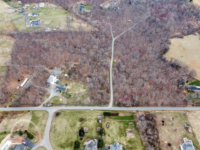
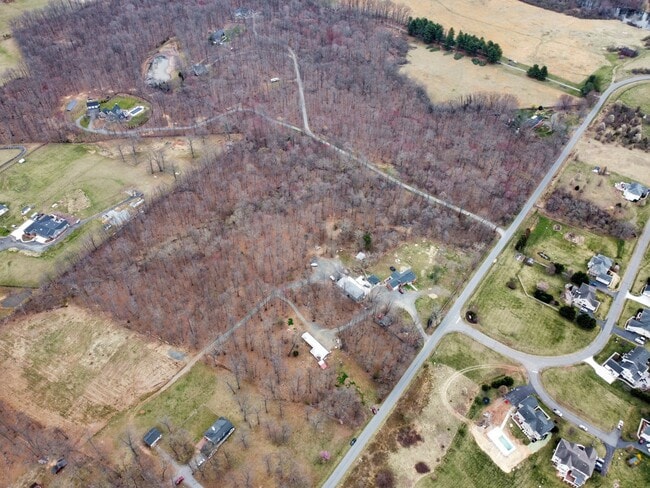
Property Record
43160 Evans Pond Rd, Leesburg, VA 20176

NEARBY LISTINGS FOR SALE OR LEASE
-
-
View all Leesburg listings for sale on LoopNet.com
Property Detail
43160 Evans Pond Rd
Washington-Arlington-Alexandria, DC-VA-MD-WV
Faith Chapel
103-47-3607
FAITH CHAPEL 201710200065740/1P 200811260069596, 939--581 HWY
Commercialnec
Loudoun
X
Virginia
51107C0110E
23
2025
19.31 AC
2025
Leesburg/West Loudoun
610503
Washington, DC
1,862 SF
DEMOGRAPHICS near 43160 Evans Pond Rd
1 Mile
3 Mile
5 Mile
2024 Total Population
777
3,500
9,727
2029 Population
869
3,937
11,185
Pop Growth 2024-2029
+ 11.84%
+ 12.49%
+ 14.99%
Average Age
38
39
40
2024 Total Households
228
1,077
3,146
HH Growth 2024-2029
+ 12.28%
+ 12.81%
+ 15.54%
Median Household Inc
$214,516
$185,714
$166,650
Avg Household Size
3.30
3.10
3.00
2024 Avg HH Vehicles
2.00
2.00
2.00
Median Home Value
$705,357
$729,538
$655,813
Median Year Built
2004
2002
1999
Nearby Places
Map Layers
Map Styles
 Street
 Aerial
- Restaurants
- Banks
- Shops
- Fitness
- Groceries
PUBLIC TRANSPORTATION
COMMUTER RAIL
Point Of Rocks (BRUNSWICK - WASHINGTON - Maryland Area Regional Commuter Trains (The MARC), Brunswick Line - Maryland Area Regional Commuter Trains (The MARC))
DRIVE
WALK
Distance
Point Of Rocks (BRUNSWICK - WASHINGTON - Maryland Area Regional Commuter Trains (The MARC), Brunswick Line - Maryland Area Regional Commuter Trains (The MARC))
11 min
5.9 mi
AIRPORT
Washington Dulles International
DRIVE
WALK
Distance
Washington Dulles International
44 min
26.8 mi
Freight Ports
Port of Baltimore
DRIVE
WALK
Distance
Port of Baltimore
85 min
66.8 mi
Nearby Properties
Address
Land Use
TOTAL SIZE
Lot Size
Zoning
Address
Land Use
TOTAL SIZE
Lot Size
Zoning
55,005 SF
15.83 AC
A
Address
Land Use
TOTAL SIZE
Lot Size
Zoning
41,594 SF
15.30 AC
CR4
Address
Land Use
TOTAL SIZE
Lot Size
Zoning
18,010 SF
14.36 AC
AR1
Address
Land Use
TOTAL SIZE
Lot Size
Zoning
29,680 SF
50.52 AC
AR1
Address
Land Use
TOTAL SIZE
Lot Size
Zoning
1,827 SF
151.26 AC
AR1
Address
Land Use
TOTAL SIZE
Lot Size
Zoning
17,642 SF
408.80 AC
AR1
Address
Land Use
TOTAL SIZE
Lot Size
Zoning
13,945 SF
101 AC
AR1
Address
Land Use
TOTAL SIZE
Lot Size
Zoning
5,981 SF
14.55 AC
AR1
Address
Land Use
TOTAL SIZE
Lot Size
Zoning
5,438 SF
50.52 AC
AR1
Address
Land Use
TOTAL SIZE
Lot Size
Zoning
25,558 SF
15.29 AC
AR1
Address
Land Use
TOTAL SIZE
Lot Size
Zoning
18,390 SF
4.78 AC
CR4
Address
Land Use
TOTAL SIZE
Lot Size
Zoning
1,408 SF
2.08 AC
RC
Address
Land Use
TOTAL SIZE
Lot Size
Zoning
625 SF
223.95 AC
AR1
Address
Land Use
TOTAL SIZE
Lot Size
Zoning
5,236 SF
52.33 AC
AR1
Address
Land Use
TOTAL SIZE
Lot Size
Zoning
7,972 SF
3.40 AC
AR1
Address
Land Use
TOTAL SIZE
Lot Size
Zoning
3,780 SF
48.50 AC
AR1
Address
Land Use
TOTAL SIZE
Lot Size
Zoning
408.38 AC
AR
Address
Land Use
TOTAL SIZE
Lot Size
Zoning
10 AC
CR1
Address
Land Use
TOTAL SIZE
Lot Size
Zoning
7,522 SF
1.07 AC
RC
Address
Land Use
TOTAL SIZE
Lot Size
Zoning
2,489 SF
17.89 AC
AR1
Address
Land Use
TOTAL SIZE
Lot Size
Zoning
1,236 SF
20 AC
AR1
Address
Land Use
TOTAL SIZE
Lot Size
Zoning
2,825 SF
0.80 AC
RC
Address
Land Use
TOTAL SIZE
Lot Size
Zoning
7,440 SF
1.50 AC
CR4
Address
Land Use
TOTAL SIZE
Lot Size
Zoning
1,828 SF
66.27 AC
AR1
Address
Land Use
TOTAL SIZE
Lot Size
Zoning
2,984 SF
31.84 AC
AR1
Address
Land Use
TOTAL SIZE
Lot Size
Zoning
3,887 SF
8 AC
RC
Address
Land Use
TOTAL SIZE
Lot Size
Zoning
2,279 SF
1.10 AC
AR1
Address
Land Use
TOTAL SIZE
Lot Size
Zoning
165.17 AC
AR
The World's #1 Commercial Real Estate Marketplace
Connect with us
© 2025 CoStar Group
The information above has been obtained from sources believed reliable. While we do not doubt its accuracy we have not verified it and make no guarantee, warranty or representation about it. It is your responsibility to independently confirm its accuracy and completeness. Any projections, opinions, assumptions, or estimates used are for example only and do not represent the current or future performance of the property. The value of this transaction to you depends on tax and other factors which should be evaluated by your tax, financial, and legal advisors. You and your advisors should conduct a careful, independent investigation of the property to determine to your satisfaction the suitability of the property for your needs.