Property Record
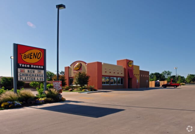
4317 50Th St, Lubbock, TX 79413

Property Detail
4317 50Th St
Lubbock, TX
DRURY PARK L 99A
R305181
Lubbock
Restaurantbuilding
Texas
B and X Area of moderate flood hazard, usually the area between the limits of the 100-year and 500-year floods.
991
2024
1.17 AC
2025
Southwest Inner Loop
001907
Lubbock
2,570 SF
NEARBY LISTINGS FOR SALE OR LEASE
DEMOGRAPHICS near 4317 50Th St
1 mile
3 mile
5 mile
2025 Total Population
15,510
116,554
245,089
2030 Population
16,014
120,534
255,223
Pop Growth 2025-2030
+ 3.25%
+ 3.41%
+ 4.13%
Average Age
37
37
36
2025 Total Households
6,216
46,478
97,067
HH Growth 2025-2030
+ 3.54%
+ 4.02%
+ 4.56%
Median Household Inc
$62,593
$55,515
$55,968
Avg Household Size
2.50
2.30
2.40
2025 Avg HH Vehicles
2.00
2.00
2.00
Median Home Value
$182,030
$208,657
$213,137
Median Year Built
1968
1974
1985
Nearby Places
Map Layers
Map Styles
 Street
 Aerial
Transit
 Traffic
 Biking
Places
Listings with unknown addresses are not visible on the map
- Restaurants
- Banks
- Shops
- Fitness
- Groceries
PUBLIC TRANSPORTATION
AIRPORT
Lubbock Preston Smith International
Drive
Walk
Distance
Lubbock Preston Smith International
29 min
15.8 mi
Freight Ports
Tulsa Port Of Catoosa
Drive
Walk
Distance
Tulsa Port Of Catoosa
512 min
473.2 mi
Nearby Properties
Address
Land Use
TOTAL SIZE
Lot Size
Zoning
Address
Land Use
TOTAL SIZE
Lot Size
Zoning
791,096 SF
63.76 AC
Address
Land Use
TOTAL SIZE
Lot Size
Zoning
106,894 SF
5.83 AC
Address
Land Use
TOTAL SIZE
Lot Size
Zoning
176,165 SF
36.61 AC
Address
Land Use
TOTAL SIZE
Lot Size
Zoning
64,800 SF
0.94 AC
Address
Land Use
TOTAL SIZE
Lot Size
Zoning
153,416 SF
3.14 AC
Address
Land Use
TOTAL SIZE
Lot Size
Zoning
289,796 SF
14.67 AC
Address
Land Use
TOTAL SIZE
Lot Size
Zoning
247,870 SF
11.48 AC
Address
Land Use
TOTAL SIZE
Lot Size
Zoning
219,352 SF
21.90 AC
Address
Land Use
TOTAL SIZE
Lot Size
Zoning
143,905 SF
0.28 AC
Address
Land Use
TOTAL SIZE
Lot Size
Zoning
156,495 SF
15.85 AC
Address
Land Use
TOTAL SIZE
Lot Size
Zoning
138,202 SF
11.33 AC
Address
Land Use
TOTAL SIZE
Lot Size
Zoning
24,540 SF
8.06 AC
Address
Land Use
TOTAL SIZE
Lot Size
Zoning
79,733 SF
3.14 AC
Address
Land Use
TOTAL SIZE
Lot Size
Zoning
100,132 SF
8.42 AC
Address
Land Use
TOTAL SIZE
Lot Size
Zoning
172,627 SF
8.12 AC
Address
Land Use
TOTAL SIZE
Lot Size
Zoning
139,501 SF
10.56 AC
Address
Land Use
TOTAL SIZE
Lot Size
Zoning
199,854 SF
19.21 AC
Address
Land Use
TOTAL SIZE
Lot Size
Zoning
220,236 SF
13.42 AC
Address
Land Use
TOTAL SIZE
Lot Size
Zoning
198,209 SF
9.98 AC
Address
Land Use
TOTAL SIZE
Lot Size
Zoning
75,154 SF
6.95 AC
Address
Land Use
TOTAL SIZE
Lot Size
Zoning
128,355 SF
8.91 AC
Address
Land Use
TOTAL SIZE
Lot Size
Zoning
139,085 SF
17.53 AC
Address
Land Use
TOTAL SIZE
Lot Size
Zoning
128,198 SF
9.88 AC
Address
Land Use
TOTAL SIZE
Lot Size
Zoning
52,020 SF
0.86 AC
Address
Land Use
TOTAL SIZE
Lot Size
Zoning
177,154 SF
8.79 AC
Address
Land Use
TOTAL SIZE
Lot Size
Zoning
164,196 SF
8.48 AC
Address
Land Use
TOTAL SIZE
Lot Size
Zoning
77,553 SF
9.63 AC
Address
Land Use
TOTAL SIZE
Lot Size
Zoning
40,258 SF
0.99 AC
Address
Land Use
TOTAL SIZE
Lot Size
Zoning
81,688 SF
2 AC
Address
Land Use
TOTAL SIZE
Lot Size
Zoning
83,300 SF
2.07 AC
The World's #1 Commercial Real Estate Marketplace
Connect with us
© 2026 CoStar Group
The information above has been obtained from sources believed reliable. While we do not doubt its accuracy we have not verified it and make no guarantee, warranty or representation about it. It is your responsibility to independently confirm its accuracy and completeness. Any projections, opinions, assumptions, or estimates used are for example only and do not represent the current or future performance of the property. The value of this transaction to you depends on tax and other factors which should be evaluated by your tax, financial, and legal advisors. You and your advisors should conduct a careful, independent investigation of the property to determine to your satisfaction the suitability of the property for your needs.