Property Record
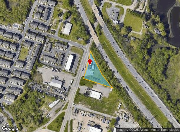
4317 Bainbridge Blvd, Chesapeake, VA 23324
NEARBY LISTINGS FOR SALE OR LEASE
Property Detail
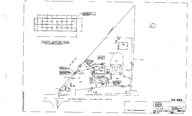
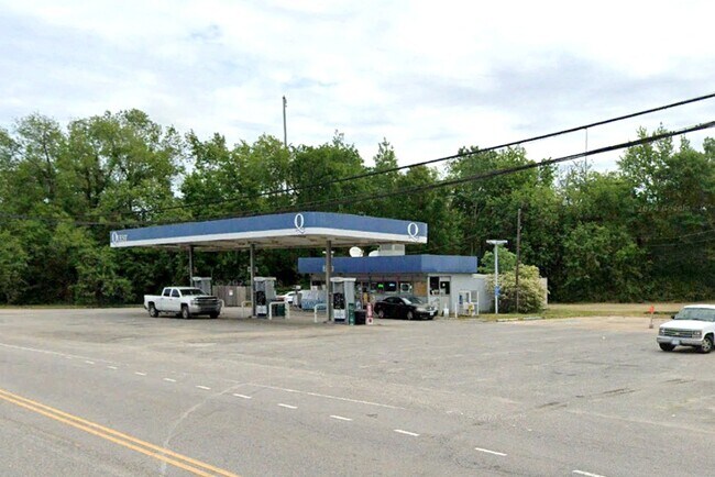
4317 Bainbridge Blvd
1580000000160
South Norfolk - Commercial
Conveniencestore
PTS OF 24-26-28 REPLAT HODGES FM
AE
Chesapeake
5100340024D
Virginia
2024
0.98 AC
2025
Campostella/S Norfolk
020600
Hampton Roads
804 SF
Virginia Beach-Chesapeake-Norfolk, VA-NC
DEMOGRAPHICS near 4317 Bainbridge Blvd
1 Mile
3 Mile
5 Mile
2024 Total Population
6,745
68,635
227,364
2029 Population
6,893
70,624
232,165
Pop Growth 2024-2029
+ 2.19%
+ 2.90%
+ 2.11%
Average Age
36
37
38
2024 Total Households
2,449
26,608
88,134
HH Growth 2024-2029
+ 2.45%
+ 3.05%
+ 2.07%
Median Household Inc
$52,056
$58,192
$64,908
Avg Household Size
2.70
2.50
2.50
2024 Avg HH Vehicles
2.00
2.00
2.00
Median Home Value
$200,867
$226,514
$248,411
Median Year Built
1977
1980
1982
Nearby Places
Map Layers
Map Styles
 Street
 Aerial
- Restaurants
- Banks
- Shops
- Fitness
- Groceries
PUBLIC TRANSPORTATION
COMMUTER RAIL
Norfolk (Northeast Regional - Amtrak)
DRIVE
WALK
Distance
Norfolk (Northeast Regional - Amtrak)
9 min
5.5 mi
AIRPORT
Norfolk International
DRIVE
WALK
Distance
Norfolk International
21 min
11.9 mi
Newport News/Williamsburg International
DRIVE
WALK
Distance
Newport News/Williamsburg International
50 min
33.6 mi
Freight Ports
Virginia Port Authority - Portsmouth
DRIVE
WALK
Distance
Virginia Port Authority - Portsmouth
18 min
9.3 mi
SALE & LEASE HISTORY
LISTING DATE
SALE/LEASE

Feb 10, 2025
For Sale
Nearby Properties
Address
Land Use
TOTAL SIZE
Lot Size
Zoning
Address
Land Use
TOTAL SIZE
Lot Size
Zoning
405,992 SF
40.22 AC
PUD: PLANN
Address
Land Use
TOTAL SIZE
Lot Size
Zoning
482.38 AC
MULTI: MUL
Address
Land Use
TOTAL SIZE
Lot Size
Zoning
743,121 SF
57.42 AC
RMF1: MULT
Address
Land Use
TOTAL SIZE
Lot Size
Zoning
358,908 SF
22.21 AC
MULTI: MUL
Address
Land Use
TOTAL SIZE
Lot Size
Zoning
258,000 SF
1.38 AC
M2: GENERA
Address
Land Use
TOTAL SIZE
Lot Size
Zoning
209,403 SF
2.81 AC
PUD: PLANN
Address
Land Use
TOTAL SIZE
Lot Size
Zoning
252,524 SF
20 AC
R8S: RESID
Address
Land Use
TOTAL SIZE
Lot Size
Zoning
168,391 SF
28.39 AC
B2: GENERA
Address
Land Use
TOTAL SIZE
Lot Size
Zoning
32,163 SF
17.59 AC
MULTI: MUL
Address
Land Use
TOTAL SIZE
Lot Size
Zoning
26.63 AC
Address
Land Use
TOTAL SIZE
Lot Size
Zoning
92,723 SF
28.83 AC
R6: RESIDE
Address
Land Use
TOTAL SIZE
Lot Size
Zoning
270,962 SF
6.17 AC
MXD-U: MIX
Address
Land Use
TOTAL SIZE
Lot Size
Zoning
401,302 SF
18.74 AC
M2: GENERA
Address
Land Use
TOTAL SIZE
Lot Size
Zoning
128,596 SF
16.91 AC
M2: GENERA
Address
Land Use
TOTAL SIZE
Lot Size
Zoning
142,656 SF
22.17 AC
RMF1: MULT
Address
Land Use
TOTAL SIZE
Lot Size
Zoning
287,268 SF
83.63 AC
MULTI: MUL
Address
Land Use
TOTAL SIZE
Lot Size
Zoning
127,755 SF
14.68 AC
PUD: PLANN
Address
Land Use
TOTAL SIZE
Lot Size
Zoning
162,291 SF
2.98 AC
PUD: PLANN
Address
Land Use
TOTAL SIZE
Lot Size
Zoning
1,880 SF
13.30 AC
PUD: PLANN
Address
Land Use
TOTAL SIZE
Lot Size
Zoning
166,753 SF
1.46 AC
PUD: PLANN
Address
Land Use
TOTAL SIZE
Lot Size
Zoning
12,240 SF
20.98 AC
MULTI: MUL
Address
Land Use
TOTAL SIZE
Lot Size
Zoning
345,432 SF
17.14 AC
PUD: PLANN
Address
Land Use
TOTAL SIZE
Lot Size
Zoning
28,253 SF
32.34 AC
M3: WATERF
Address
Land Use
TOTAL SIZE
Lot Size
Zoning
119,946 SF
9.76 AC
M2: GENERA
Address
Land Use
TOTAL SIZE
Lot Size
Zoning
336,005 SF
15.32 AC
M1: LIGHT
Address
Land Use
TOTAL SIZE
Lot Size
Zoning
49,720 SF
27.37 AC
B2: GENERA
Address
Land Use
TOTAL SIZE
Lot Size
Zoning
88,000 SF
37.05 AC
M2: GENERA
Address
Land Use
TOTAL SIZE
Lot Size
Zoning
144,984 SF
6.34 AC
O-I: OFFIC
Address
Land Use
TOTAL SIZE
Lot Size
Zoning
121,111 SF
16.68 AC
B3: HIGHWA
Address
Land Use
TOTAL SIZE
Lot Size
Zoning
119,870 SF
12.21 AC
B3: HIGHWA
The World's #1 Commercial Real Estate Marketplace
Connect with us
© 2026 CoStar Group
The information above has been obtained from sources believed reliable. While we do not doubt its accuracy we have not verified it and make no guarantee, warranty or representation about it. It is your responsibility to independently confirm its accuracy and completeness. Any projections, opinions, assumptions, or estimates used are for example only and do not represent the current or future performance of the property. The value of this transaction to you depends on tax and other factors which should be evaluated by your tax, financial, and legal advisors. You and your advisors should conduct a careful, independent investigation of the property to determine to your satisfaction the suitability of the property for your needs.