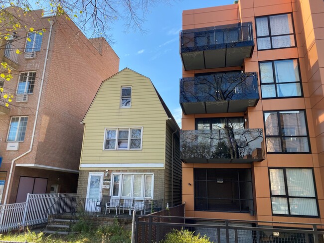
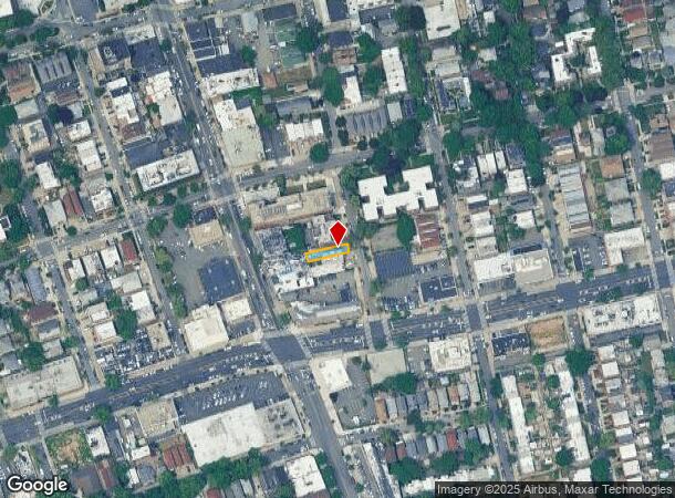
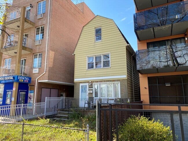
Property Record
4318 214Th Pl, Bayside, NY 11361

NEARBY LISTINGS FOR SALE OR LEASE
Property Detail
4318 214Th Pl
06300-0034
Queens
Commercialofficeresidentialmixeduse
New York
X
34
3604970119F
0.07 AC
2024
Northeast Queens
2025
Long Island (New York)
146700
New York-Jersey City-White Plains, NY-NJ
2,400 SF
DEMOGRAPHICS near 4318 214Th Pl
1 mile
3 mile
5 mile
2024 Total Population
38,475
380,511
1,036,841
2029 Population
35,762
357,998
976,522
Pop Growth 2024-2029
(7.05%)
(5.92%)
(5.82%)
Average Age
44
45
43
2024 Total Households
13,689
138,117
356,954
HH Growth 2024-2029
(7.53%)
(6.24%)
(6.00%)
Median Household Inc
$91,883
$76,424
$78,268
Avg Household Size
2.70
2.70
2.80
2024 Avg HH Vehicles
2.00
1.00
1.00
Median Home Value
$832,293
$744,259
$705,271
Median Year Built
1954
1955
1954
Nearby Places
Map Layers
Map Styles
 Street
 Aerial
Transit
 Traffic
 Biking
Places
Listings with unknown addresses are not visible on the map
- Restaurants
- Banks
- Shops
- Fitness
- Groceries
PUBLIC TRANSPORTATION
TRANSIT/SUBWAY
Bayside Station (Port Washington Branch - Long Island Rail Road)
Drive
Walk
Distance
Bayside Station (Port Washington Branch - Long Island Rail Road)
1 min
5 min
0.3 mi
COMMUTER RAIL
Bayside Station (Port Washington Branch - Long Island Rail Road)
Drive
Walk
Distance
Bayside Station (Port Washington Branch - Long Island Rail Road)
1 min
6 min
0.3 mi
Auburndale Station (Port Washington Branch - Long Island Rail Road)
Drive
Walk
Distance
Auburndale Station (Port Washington Branch - Long Island Rail Road)
4 min
1.5 mi
AIRPORT
LaGuardia
Drive
Walk
Distance
LaGuardia
17 min
6.9 mi
John F Kennedy International
Drive
Walk
Distance
John F Kennedy International
20 min
11.5 mi
Westchester County
Drive
Walk
Distance
Westchester County
43 min
28.4 mi
Freight Ports
NY - Red Hook Container Terminal
Drive
Walk
Distance
NY - Red Hook Container Terminal
27 min
16.9 mi
SALE & LEASE HISTORY
LISTING DATE
SALE/LEASE

Jun 10, 2021
For Sale
Jan 15, 2021
For Sale
Nearby Properties
Address
Land Use
TOTAL SIZE
Lot Size
Zoning
Address
Land Use
TOTAL SIZE
Lot Size
Zoning
2,697,663 SF
3.46 AC
C5-3
Address
Land Use
TOTAL SIZE
Lot Size
Zoning
1,666,696 SF
1.87 AC
C52.5
Address
Land Use
TOTAL SIZE
Lot Size
Zoning
7,975 SF
133 AC
PARK
Address
Land Use
TOTAL SIZE
Lot Size
Zoning
97.07 AC
R3-2
Address
Land Use
TOTAL SIZE
Lot Size
Zoning
97.07 AC
R3-2
Address
Land Use
TOTAL SIZE
Lot Size
Zoning
97.07 AC
R3-2
Address
Land Use
TOTAL SIZE
Lot Size
Zoning
97.07 AC
R3-2
Address
Land Use
TOTAL SIZE
Lot Size
Zoning
97.07 AC
R3-2
Address
Land Use
TOTAL SIZE
Lot Size
Zoning
97.07 AC
R3-2
Address
Land Use
TOTAL SIZE
Lot Size
Zoning
97.07 AC
R3-2
Address
Land Use
TOTAL SIZE
Lot Size
Zoning
97.07 AC
R3-2
Address
Land Use
TOTAL SIZE
Lot Size
Zoning
97.07 AC
R3-2
Address
Land Use
TOTAL SIZE
Lot Size
Zoning
97.07 AC
R3-2
Address
Land Use
TOTAL SIZE
Lot Size
Zoning
97.07 AC
R3-2
Address
Land Use
TOTAL SIZE
Lot Size
Zoning
97.07 AC
R3-2
Address
Land Use
TOTAL SIZE
Lot Size
Zoning
97.07 AC
R3-2
Address
Land Use
TOTAL SIZE
Lot Size
Zoning
97.07 AC
R3-2
Address
Land Use
TOTAL SIZE
Lot Size
Zoning
97.07 AC
R3-2
Address
Land Use
TOTAL SIZE
Lot Size
Zoning
97.07 AC
R3-2
Address
Land Use
TOTAL SIZE
Lot Size
Zoning
97.07 AC
R3-2
Address
Land Use
TOTAL SIZE
Lot Size
Zoning
97.07 AC
R3-2
Address
Land Use
TOTAL SIZE
Lot Size
Zoning
97.07 AC
R3-2
Address
Land Use
TOTAL SIZE
Lot Size
Zoning
97.07 AC
R3-2
Address
Land Use
TOTAL SIZE
Lot Size
Zoning
97.07 AC
R3-2
Address
Land Use
TOTAL SIZE
Lot Size
Zoning
97.07 AC
R3-2
Address
Land Use
TOTAL SIZE
Lot Size
Zoning
97.07 AC
R3-2
Address
Land Use
TOTAL SIZE
Lot Size
Zoning
97.07 AC
R3-2
Address
Land Use
TOTAL SIZE
Lot Size
Zoning
97.07 AC
R3-2
Address
Land Use
TOTAL SIZE
Lot Size
Zoning
97.07 AC
R3-2
Address
Land Use
TOTAL SIZE
Lot Size
Zoning
97.07 AC
R3-2
The World's #1 Commercial Real Estate Marketplace
Connect with us
© 2026 CoStar Group
The information above has been obtained from sources believed reliable. While we do not doubt its accuracy we have not verified it and make no guarantee, warranty or representation about it. It is your responsibility to independently confirm its accuracy and completeness. Any projections, opinions, assumptions, or estimates used are for example only and do not represent the current or future performance of the property. The value of this transaction to you depends on tax and other factors which should be evaluated by your tax, financial, and legal advisors. You and your advisors should conduct a careful, independent investigation of the property to determine to your satisfaction the suitability of the property for your needs.