Property Record
4315 9Th St, Bacliff, TX 77518
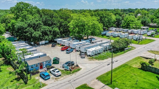

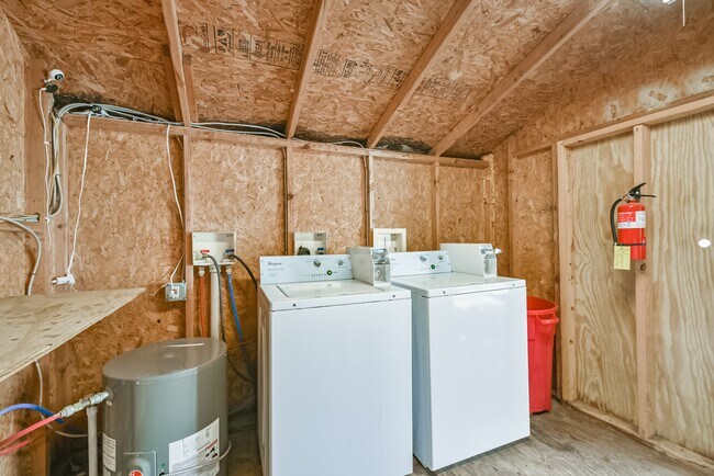
Property Detail
4315 9Th St
Houston-Pasadena-The Woodlands, TX
ABST 164 E PAYNE SUR LOTS 45 THRU 48 BLK 74 & 11 THRU 16 (15-0) BLK 75 CLIFTON BY THE SEA REPLAT
2655-0075-0015-000
Galveston
Commercialnec
Texas
C and X Area of minimal flood hazard, usually depicted on FIRMs as above the 500-year flood level.
45-48
2024
0.72 AC
2025
Southeast Outlier
721701
Houston
33 SF
NEARBY LISTINGS FOR SALE OR LEASE
DEMOGRAPHICS near 4315 9Th St
1 mile
3 mile
5 mile
2025 Total Population
9,681
24,764
80,157
2030 Population
10,053
25,835
83,070
Pop Growth 2025-2030
+ 3.84%
+ 4.32%
+ 3.63%
Average Age
37
37
39
2025 Total Households
3,440
8,633
29,764
HH Growth 2025-2030
+ 3.78%
+ 4.38%
+ 3.67%
Median Household Inc
$56,274
$94,719
$98,201
Avg Household Size
2.70
2.80
2.60
2025 Avg HH Vehicles
2.00
2.00
2.00
Median Home Value
$205,896
$302,402
$323,299
Median Year Built
1987
1999
1995
Nearby Places
Map Layers
Map Styles
 Street
 Aerial
Layers
 Traffic
 Biking
Places
Listings with unknown addresses are not visible on the map
- Restaurants
- Banks
- Shops
- Fitness
- Groceries
PUBLIC TRANSPORTATION
AIRPORT
William P Hobby
Drive
Walk
Distance
William P Hobby
41 min
25.1 mi
Freight Ports
Port of Galveston
Drive
Walk
Distance
Port of Galveston
27 min
21.8 mi
SALE & LEASE HISTORY
LISTING DATE
SALE/LEASE

Jun 09, 2022
For Sale
Nearby Properties
Address
Land Use
TOTAL SIZE
Lot Size
Zoning
Address
Land Use
TOTAL SIZE
Lot Size
Zoning
500,000 SF
125.06 AC
Address
Land Use
TOTAL SIZE
Lot Size
Zoning
320,892 SF
15 AC
Address
Land Use
TOTAL SIZE
Lot Size
Zoning
415,941 SF
14.35 AC
Address
Land Use
TOTAL SIZE
Lot Size
Zoning
Address
Land Use
TOTAL SIZE
Lot Size
Zoning
38.73 AC
Address
Land Use
TOTAL SIZE
Lot Size
Zoning
90,291 SF
1.81 AC
Address
Land Use
TOTAL SIZE
Lot Size
Zoning
206,147 SF
20.51 AC
Address
Land Use
TOTAL SIZE
Lot Size
Zoning
79,018 SF
9.34 AC
Address
Land Use
TOTAL SIZE
Lot Size
Zoning
114,488 SF
20 AC
Address
Land Use
TOTAL SIZE
Lot Size
Zoning
105,218 SF
4.91 AC
Address
Land Use
TOTAL SIZE
Lot Size
Zoning
60,216 SF
5.99 AC
Address
Land Use
TOTAL SIZE
Lot Size
Zoning
130,457 SF
14.12 AC
Address
Land Use
TOTAL SIZE
Lot Size
Zoning
121,266 SF
9.09 AC
Address
Land Use
TOTAL SIZE
Lot Size
Zoning
137,088 SF
10.08 AC
Address
Land Use
TOTAL SIZE
Lot Size
Zoning
95,882 SF
5.41 AC
Address
Land Use
TOTAL SIZE
Lot Size
Zoning
103,138 SF
4.84 AC
Address
Land Use
TOTAL SIZE
Lot Size
Zoning
33,788 SF
3.06 AC
Address
Land Use
TOTAL SIZE
Lot Size
Zoning
Address
Land Use
TOTAL SIZE
Lot Size
Zoning
60,807 SF
12.17 AC
Address
Land Use
TOTAL SIZE
Lot Size
Zoning
105,600 SF
10.07 AC
Address
Land Use
TOTAL SIZE
Lot Size
Zoning
11,076 SF
1.80 AC
Address
Land Use
TOTAL SIZE
Lot Size
Zoning
102,155 SF
5 AC
Address
Land Use
TOTAL SIZE
Lot Size
Zoning
16,425 SF
2.49 AC
Address
Land Use
TOTAL SIZE
Lot Size
Zoning
17,000 SF
1.85 AC
Address
Land Use
TOTAL SIZE
Lot Size
Zoning
15,342 SF
23.22 AC
Address
Land Use
TOTAL SIZE
Lot Size
Zoning
15,288 SF
1.43 AC
Address
Land Use
TOTAL SIZE
Lot Size
Zoning
26,186 SF
2.24 AC
Address
Land Use
TOTAL SIZE
Lot Size
Zoning
57,804 SF
3 AC
Address
Land Use
TOTAL SIZE
Lot Size
Zoning
71,450 SF
4.36 AC
Address
Land Use
TOTAL SIZE
Lot Size
Zoning
16,769 SF
1.71 AC
The World's #1 Commercial Real Estate Marketplace
Connect with us
© 2026 CoStar Group
The information above has been obtained from sources believed reliable. While we do not doubt its accuracy we have not verified it and make no guarantee, warranty or representation about it. It is your responsibility to independently confirm its accuracy and completeness. Any projections, opinions, assumptions, or estimates used are for example only and do not represent the current or future performance of the property. The value of this transaction to you depends on tax and other factors which should be evaluated by your tax, financial, and legal advisors. You and your advisors should conduct a careful, independent investigation of the property to determine to your satisfaction the suitability of the property for your needs.