Property Record
432 N 6Th St, Clairton, PA 15025


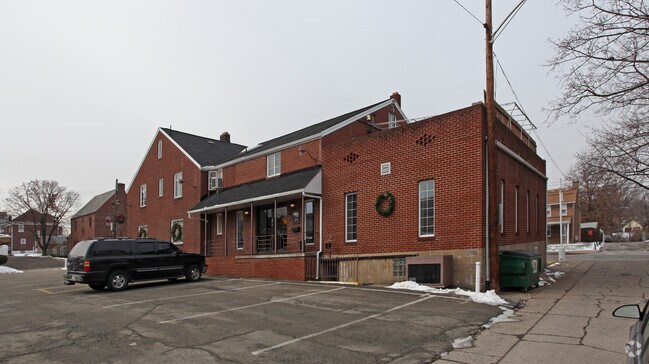
Property Detail
432 N 6Th St
Pittsburgh, PA
A G & J T WILSON 4TH PLAN 283-284-285 PT 282 LO T 85X120 IN ALL SIXTH ST NORTH COR WALNUT 2 STY BRK V HSE & FUNERAL HOME-
0764-B-00316-0000-00
Allegheny
Funeralhome
Pennsylvania
B and X Area of moderate flood hazard, usually the area between the limits of the 100-year and 500-year floods.
316
2024
0.23 AC
2025
South Pittsburgh/Rte 51
492700
Pittsburgh
NEARBY LISTINGS FOR SALE OR LEASE
DEMOGRAPHICS near 432 N 6Th St
1 mile
3 mile
5 mile
2025 Total Population
4,491
30,773
101,810
2030 Population
4,590
30,832
101,496
Pop Growth 2025-2030
+ 2.20%
+ 0.19%
(0.31%)
Average Age
43
44
44
2025 Total Households
2,048
13,410
43,807
HH Growth 2025-2030
+ 2.29%
+ 0.20%
(0.34%)
Median Household Inc
$44,745
$60,367
$63,992
Avg Household Size
2.10
2.20
2.20
2025 Avg HH Vehicles
1.00
2.00
2.00
Median Home Value
$83,518
$128,872
$154,863
Median Year Built
1948
1952
1954
Nearby Places
Map Layers
Map Styles
 Street
 Aerial
Transit
 Traffic
 Biking
Places
Listings with unknown addresses are not visible on the map
- Restaurants
- Banks
- Shops
- Fitness
- Groceries
PUBLIC TRANSPORTATION
AIRPORT
Pittsburgh International
Drive
Walk
Distance
Pittsburgh International
51 min
29.5 mi
Arnold Palmer Regional
Drive
Walk
Distance
Arnold Palmer Regional
61 min
33.2 mi
Nearby Properties
Address
Land Use
TOTAL SIZE
Lot Size
Zoning
Address
Land Use
TOTAL SIZE
Lot Size
Zoning
183.54 AC
Address
Land Use
TOTAL SIZE
Lot Size
Zoning
160.53 AC
Address
Land Use
TOTAL SIZE
Lot Size
Zoning
33.09 AC
Address
Land Use
TOTAL SIZE
Lot Size
Zoning
14.61 AC
Address
Land Use
TOTAL SIZE
Lot Size
Zoning
460.86 AC
Address
Land Use
TOTAL SIZE
Lot Size
Zoning
2.98 AC
Address
Land Use
TOTAL SIZE
Lot Size
Zoning
72.10 AC
Address
Land Use
TOTAL SIZE
Lot Size
Zoning
74.33 AC
Address
Land Use
TOTAL SIZE
Lot Size
Zoning
37.90 AC
Address
Land Use
TOTAL SIZE
Lot Size
Zoning
43.15 AC
Address
Land Use
TOTAL SIZE
Lot Size
Zoning
35.72 AC
Address
Land Use
TOTAL SIZE
Lot Size
Zoning
2.77 AC
Address
Land Use
TOTAL SIZE
Lot Size
Zoning
10.13 AC
Address
Land Use
TOTAL SIZE
Lot Size
Zoning
242.22 AC
Address
Land Use
TOTAL SIZE
Lot Size
Zoning
Address
Land Use
TOTAL SIZE
Lot Size
Zoning
14.49 AC
Address
Land Use
TOTAL SIZE
Lot Size
Zoning
24.86 AC
Address
Land Use
TOTAL SIZE
Lot Size
Zoning
Address
Land Use
TOTAL SIZE
Lot Size
Zoning
24.24 AC
Address
Land Use
TOTAL SIZE
Lot Size
Zoning
77.33 AC
Address
Land Use
TOTAL SIZE
Lot Size
Zoning
Address
Land Use
TOTAL SIZE
Lot Size
Zoning
0.93 AC
Address
Land Use
TOTAL SIZE
Lot Size
Zoning
13.96 AC
Address
Land Use
TOTAL SIZE
Lot Size
Zoning
Address
Land Use
TOTAL SIZE
Lot Size
Zoning
7.03 AC
Address
Land Use
TOTAL SIZE
Lot Size
Zoning
5.50 AC
Address
Land Use
TOTAL SIZE
Lot Size
Zoning
1.80 AC
Address
Land Use
TOTAL SIZE
Lot Size
Zoning
25.39 AC
Address
Land Use
TOTAL SIZE
Lot Size
Zoning
8.90 AC
Address
Land Use
TOTAL SIZE
Lot Size
Zoning
2.80 AC
The World's #1 Commercial Real Estate Marketplace
Connect with us
© 2026 CoStar Group
The information above has been obtained from sources believed reliable. While we do not doubt its accuracy we have not verified it and make no guarantee, warranty or representation about it. It is your responsibility to independently confirm its accuracy and completeness. Any projections, opinions, assumptions, or estimates used are for example only and do not represent the current or future performance of the property. The value of this transaction to you depends on tax and other factors which should be evaluated by your tax, financial, and legal advisors. You and your advisors should conduct a careful, independent investigation of the property to determine to your satisfaction the suitability of the property for your needs.