Property Record
4320 Charlotte Hwy, Clover, SC 29710
NEARBY LISTINGS FOR SALE OR LEASE
Property Detail
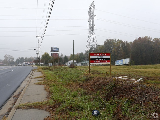
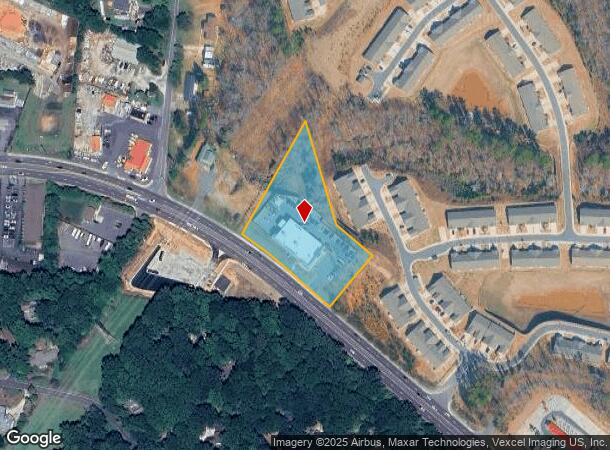
4320 Charlotte Hwy
5750000007
(2.3747AC) CHARLOTTE HWY
Commercialnec
York
X
South Carolina
3710358000J
2.38 AC
2025
York County
2025
Charlotte
061709
Charlotte-Concord-Gastonia, NC-SC
12,234 SF
DEMOGRAPHICS near 4320 Charlotte Hwy
1 Mile
3 Mile
5 Mile
2024 Total Population
4,668
27,777
88,685
2029 Population
5,344
31,057
97,186
Pop Growth 2024-2029
+ 14.48%
+ 11.81%
+ 9.59%
Average Age
43
41
39
2024 Total Households
2,097
10,900
33,725
HH Growth 2024-2029
+ 14.78%
+ 12.20%
+ 9.81%
Median Household Inc
$110,080
$113,709
$103,109
Avg Household Size
2.20
2.50
2.60
2024 Avg HH Vehicles
2.00
2.00
2.00
Median Home Value
$484,155
$444,411
$369,298
Median Year Built
1999
2006
2006
Nearby Places
Map Layers
Map Styles
 Street
 Aerial
- Restaurants
- Banks
- Shops
- Fitness
- Groceries
PUBLIC TRANSPORTATION
AIRPORT
Charlotte/Douglas International
DRIVE
WALK
Distance
Charlotte/Douglas International
26 min
14.2 mi
Concord-Padgett Regional
DRIVE
WALK
Distance
Concord-Padgett Regional
47 min
35.8 mi
Freight Ports
North Charleston Terminal
DRIVE
WALK
Distance
North Charleston Terminal
220 min
192.6 mi
SALE & LEASE HISTORY
LISTING DATE
SALE/LEASE

Sep 24, 2016
For Sale
Nearby Properties
Address
Land Use
TOTAL SIZE
Lot Size
Zoning
Address
Land Use
TOTAL SIZE
Lot Size
Zoning
415,150 SF
18.68 AC
MX-3
Address
Land Use
TOTAL SIZE
Lot Size
Zoning
298,790 SF
18.23 AC
MX3
Address
Land Use
TOTAL SIZE
Lot Size
Zoning
238.36 AC
R-3
Address
Land Use
TOTAL SIZE
Lot Size
Zoning
972 SF
6.91 AC
B-2
Address
Land Use
TOTAL SIZE
Lot Size
Zoning
89,902 SF
28.37 AC
R-3
Address
Land Use
TOTAL SIZE
Lot Size
Zoning
7,604 SF
169.25 AC
R5
Address
Land Use
TOTAL SIZE
Lot Size
Zoning
95 AC
RUD
Address
Land Use
TOTAL SIZE
Lot Size
Zoning
87.82 AC
R-3
Address
Land Use
TOTAL SIZE
Lot Size
Zoning
21,537 SF
3.32 AC
BDIII
Address
Land Use
TOTAL SIZE
Lot Size
Zoning
5,000 SF
14.33 AC
R-5
Address
Land Use
TOTAL SIZE
Lot Size
Zoning
35,174 SF
6.74 AC
B2CD
Address
Land Use
TOTAL SIZE
Lot Size
Zoning
11.62 AC
R-5
Address
Land Use
TOTAL SIZE
Lot Size
Zoning
5.45 AC
UD
Address
Land Use
TOTAL SIZE
Lot Size
Zoning
7,028 SF
11.62 AC
MX3
Address
Land Use
TOTAL SIZE
Lot Size
Zoning
38,142 SF
30.01 AC
PD
Address
Land Use
TOTAL SIZE
Lot Size
Zoning
27,372 SF
14.37 AC
RDII
Address
Land Use
TOTAL SIZE
Lot Size
Zoning
2,387 SF
4.58 AC
Address
Land Use
TOTAL SIZE
Lot Size
Zoning
13.46 AC
MX-3
Address
Land Use
TOTAL SIZE
Lot Size
Zoning
4,976 SF
3.81 AC
B2
Address
Land Use
TOTAL SIZE
Lot Size
Zoning
14.43 AC
RDI
Address
Land Use
TOTAL SIZE
Lot Size
Zoning
27,600 SF
35.50 AC
RDI
Address
Land Use
TOTAL SIZE
Lot Size
Zoning
11,851 SF
0.65 AC
Address
Land Use
TOTAL SIZE
Lot Size
Zoning
7,840 SF
10.44 AC
RDI
Address
Land Use
TOTAL SIZE
Lot Size
Zoning
4.97 AC
BDI
Address
Land Use
TOTAL SIZE
Lot Size
Zoning
44,977 SF
24.59 AC
BDIII
Address
Land Use
TOTAL SIZE
Lot Size
Zoning
8.89 AC
BDIII
Address
Land Use
TOTAL SIZE
Lot Size
Zoning
10.56 AC
Address
Land Use
TOTAL SIZE
Lot Size
Zoning
10.18 AC
Address
Land Use
TOTAL SIZE
Lot Size
Zoning
3.89 AC
BDIII
Address
Land Use
TOTAL SIZE
Lot Size
Zoning
4.43 AC
B-1
The World's #1 Commercial Real Estate Marketplace
Connect with us
© 2025 CoStar Group
The information above has been obtained from sources believed reliable. While we do not doubt its accuracy we have not verified it and make no guarantee, warranty or representation about it. It is your responsibility to independently confirm its accuracy and completeness. Any projections, opinions, assumptions, or estimates used are for example only and do not represent the current or future performance of the property. The value of this transaction to you depends on tax and other factors which should be evaluated by your tax, financial, and legal advisors. You and your advisors should conduct a careful, independent investigation of the property to determine to your satisfaction the suitability of the property for your needs.