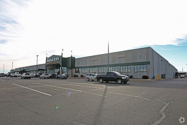
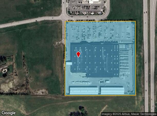
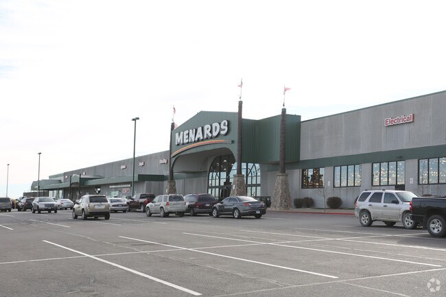
Property Record
4320 Commonwealth Dr, Saint Joseph, MO 64503
NEARBY LISTINGS FOR SALE OR LEASE
Property Detail
4320 Commonwealth Dr
Kansas City
The Commons
St. Joseph, MO-KS
26-57-35SESUB:THE COMMONS LOT:14 BLK:LGL DESC:
06-7.0-26-004-000-010.014
Buchanan
Storebuilding
Missouri
2023
14
2025
16.43 AC
002200
St Joseph
161,940 SF
DEMOGRAPHICS near 4320 Commonwealth Dr
1 Mile
3 Mile
5 Mile
2024 Total Population
1,041
16,838
57,257
2029 Population
998
16,286
55,974
Pop Growth 2024-2029
(4.13%)
(3.28%)
(2.24%)
Average Age
43
40
40
2024 Total Households
425
6,962
22,990
HH Growth 2024-2029
(4.24%)
(3.40%)
(2.26%)
Median Household Inc
$65,000
$62,701
$45,606
Avg Household Size
2.40
2.40
2.30
2024 Avg HH Vehicles
2.00
2.00
2.00
Median Home Value
$199,106
$151,035
$139,382
Median Year Built
1977
1967
1960
Nearby Places
Map Layers
Map Styles
 Street
 Aerial
- Restaurants
- Banks
- Shops
- Fitness
- Groceries
PUBLIC TRANSPORTATION
AIRPORT
Kansas City International
DRIVE
WALK
Distance
Kansas City International
38 min
32.4 mi
Freight Ports
Tulsa Port Of Catoosa
DRIVE
WALK
Distance
Tulsa Port Of Catoosa
315 min
283.9 mi
Nearby Properties
Address
Land Use
TOTAL SIZE
Lot Size
Zoning
Address
Land Use
TOTAL SIZE
Lot Size
Zoning
140,200 SF
141.50 AC
CITY
Address
Land Use
TOTAL SIZE
Lot Size
Zoning
151,500 SF
38.50 AC
CITY
Address
Land Use
TOTAL SIZE
Lot Size
Zoning
141,520 SF
Address
Land Use
TOTAL SIZE
Lot Size
Zoning
85,350 SF
Address
Land Use
TOTAL SIZE
Lot Size
Zoning
Address
Land Use
TOTAL SIZE
Lot Size
Zoning
30,864 SF
79.61 AC
CITY
Address
Land Use
TOTAL SIZE
Lot Size
Zoning
22.72 AC
CITY
Address
Land Use
TOTAL SIZE
Lot Size
Zoning
37,100 SF
17.24 AC
CITY
Address
Land Use
TOTAL SIZE
Lot Size
Zoning
383,764 SF
7 AC
CITY
Address
Land Use
TOTAL SIZE
Lot Size
Zoning
258,800 SF
19.51 AC
CITY
Address
Land Use
TOTAL SIZE
Lot Size
Zoning
3,947 SF
8.29 AC
CITY
Address
Land Use
TOTAL SIZE
Lot Size
Zoning
60,036 SF
88.08 AC
CITY
Address
Land Use
TOTAL SIZE
Lot Size
Zoning
62,595 SF
4.15 AC
CITY
Address
Land Use
TOTAL SIZE
Lot Size
Zoning
89,165 SF
23 AC
CITY
Address
Land Use
TOTAL SIZE
Lot Size
Zoning
62,733 SF
15.40 AC
CITY
Address
Land Use
TOTAL SIZE
Lot Size
Zoning
18,017 SF
5.24 AC
CITY
Address
Land Use
TOTAL SIZE
Lot Size
Zoning
Address
Land Use
TOTAL SIZE
Lot Size
Zoning
Address
Land Use
TOTAL SIZE
Lot Size
Zoning
32,855 SF
27.35 AC
CITY
Address
Land Use
TOTAL SIZE
Lot Size
Zoning
22,680 SF
Address
Land Use
TOTAL SIZE
Lot Size
Zoning
61,240 SF
15.80 AC
CITY
Address
Land Use
TOTAL SIZE
Lot Size
Zoning
41,454 SF
6.28 AC
CITY
Address
Land Use
TOTAL SIZE
Lot Size
Zoning
40,812 SF
15.37 AC
R-1
Address
Land Use
TOTAL SIZE
Lot Size
Zoning
Address
Land Use
TOTAL SIZE
Lot Size
Zoning
9,614 SF
2.29 AC
CITY
Address
Land Use
TOTAL SIZE
Lot Size
Zoning
333,670 SF
49.03 AC
CITY
Address
Land Use
TOTAL SIZE
Lot Size
Zoning
311,177 SF
19.30 AC
CITY
Address
Land Use
TOTAL SIZE
Lot Size
Zoning
93,701 SF
10.93 AC
CITY
Address
Land Use
TOTAL SIZE
Lot Size
Zoning
155,836 SF
23.23 AC
CITY
The World's #1 Commercial Real Estate Marketplace
Connect with us
© 2025 CoStar Group
The information above has been obtained from sources believed reliable. While we do not doubt its accuracy we have not verified it and make no guarantee, warranty or representation about it. It is your responsibility to independently confirm its accuracy and completeness. Any projections, opinions, assumptions, or estimates used are for example only and do not represent the current or future performance of the property. The value of this transaction to you depends on tax and other factors which should be evaluated by your tax, financial, and legal advisors. You and your advisors should conduct a careful, independent investigation of the property to determine to your satisfaction the suitability of the property for your needs.