Property Record
4320 Goldmine Rd, Monroe, NC 28110
NEARBY LISTINGS FOR SALE OR LEASE
Property Detail
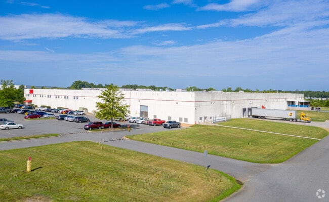
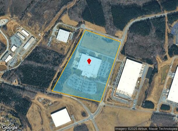
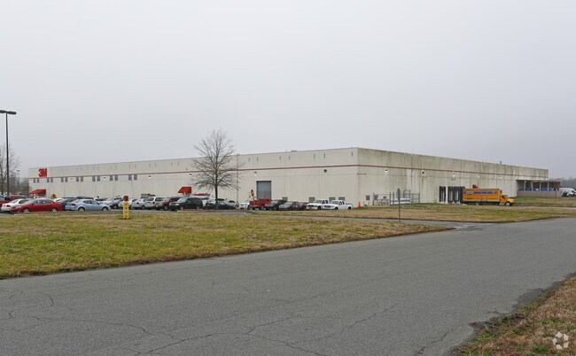
4320 Goldmine Rd
09-399-002-D
#9 CITY OF MONROE 4320 GOLDMINE RD
Manufacturinglight
Union
X
North Carolina
3710540600J
9
2025
35 AC
2025
Union County
020307
Charlotte
201,214 SF
Charlotte-Concord-Gastonia, NC-SC
DEMOGRAPHICS near 4320 Goldmine Rd
1 Mile
3 Mile
5 Mile
2024 Total Population
3,864
30,769
81,796
2029 Population
4,292
34,560
91,990
Pop Growth 2024-2029
+ 11.08%
+ 12.32%
+ 12.46%
Average Age
39
38
38
2024 Total Households
1,362
10,302
27,964
HH Growth 2024-2029
+ 11.23%
+ 12.48%
+ 12.67%
Median Household Inc
$95,520
$92,192
$90,883
Avg Household Size
2.80
2.90
2.90
2024 Avg HH Vehicles
3.00
2.00
2.00
Median Home Value
$263,377
$295,486
$312,587
Median Year Built
2001
2002
2000
Nearby Places
Map Layers
Map Styles
 Street
 Aerial
- Restaurants
- Banks
- Shops
- Fitness
- Groceries
PUBLIC TRANSPORTATION
AIRPORT
Charlotte/Douglas International
DRIVE
WALK
Distance
Charlotte/Douglas International
46 min
29.4 mi
Concord-Padgett Regional
DRIVE
WALK
Distance
Concord-Padgett Regional
49 min
34.9 mi
Nearby Properties
Address
Land Use
TOTAL SIZE
Lot Size
Zoning
Address
Land Use
TOTAL SIZE
Lot Size
Zoning
124.87 AC
LI UNION C
Address
Land Use
TOTAL SIZE
Lot Size
Zoning
150,880 SF
73.40 AC
G-I MONROE
Address
Land Use
TOTAL SIZE
Lot Size
Zoning
166,254 SF
99.20 AC
G-I MONROE
Address
Land Use
TOTAL SIZE
Lot Size
Zoning
83,808 SF
23.45 AC
CD MONROE
Address
Land Use
TOTAL SIZE
Lot Size
Zoning
2,048 SF
17.71 AC
GB MONROE
Address
Land Use
TOTAL SIZE
Lot Size
Zoning
35.14 AC
G-I MONROE
Address
Land Use
TOTAL SIZE
Lot Size
Zoning
98,929 SF
50.34 AC
SF-1 INDIA
Address
Land Use
TOTAL SIZE
Lot Size
Zoning
263,636 SF
20.36 AC
G-I MONROE
Address
Land Use
TOTAL SIZE
Lot Size
Zoning
49,710 SF
14.20 AC
CZ INDIAN
Address
Land Use
TOTAL SIZE
Lot Size
Zoning
159,892 SF
15.84 AC
G-I MONROE
Address
Land Use
TOTAL SIZE
Lot Size
Zoning
103,100 SF
28.55 AC
RBD INDIAN
Address
Land Use
TOTAL SIZE
Lot Size
Zoning
95,700 SF
24.87 AC
G-I MONROE
Address
Land Use
TOTAL SIZE
Lot Size
Zoning
2,968 SF
9.34 AC
R-20 UNION
Address
Land Use
TOTAL SIZE
Lot Size
Zoning
97,083 SF
32.30 AC
R-40 MONRO
Address
Land Use
TOTAL SIZE
Lot Size
Zoning
105,218 SF
40.66 AC
G-I MONROE
Address
Land Use
TOTAL SIZE
Lot Size
Zoning
79,930 SF
261.95 AC
RBD INDIAN
Address
Land Use
TOTAL SIZE
Lot Size
Zoning
145,600 SF
11.75 AC
G-I MONROE
Address
Land Use
TOTAL SIZE
Lot Size
Zoning
118,802 SF
10.82 AC
G-I MONROE
Address
Land Use
TOTAL SIZE
Lot Size
Zoning
13,141 SF
174.76 AC
G-I MONROE
Address
Land Use
TOTAL SIZE
Lot Size
Zoning
105,820 SF
20 AC
G-I MONROE
Address
Land Use
TOTAL SIZE
Lot Size
Zoning
246,033 SF
35 AC
G-I MONROE
Address
Land Use
TOTAL SIZE
Lot Size
Zoning
69,298 SF
10.29 AC
GBD INDIAN
Address
Land Use
TOTAL SIZE
Lot Size
Zoning
52,379 SF
2.11 AC
GBD INDIAN
Address
Land Use
TOTAL SIZE
Lot Size
Zoning
174,518 SF
27.54 AC
G-I MONROE
Address
Land Use
TOTAL SIZE
Lot Size
Zoning
64,402 SF
43.06 AC
SF-1 INDIA
Address
Land Use
TOTAL SIZE
Lot Size
Zoning
65,515 SF
27.66 AC
G-I MONROE
Address
Land Use
TOTAL SIZE
Lot Size
Zoning
30.42 AC
HC UNION C
Address
Land Use
TOTAL SIZE
Lot Size
Zoning
12.67 AC
Address
Land Use
TOTAL SIZE
Lot Size
Zoning
53,930 SF
21.74 AC
G-I MONROE
The World's #1 Commercial Real Estate Marketplace
Connect with us
© 2026 CoStar Group
The information above has been obtained from sources believed reliable. While we do not doubt its accuracy we have not verified it and make no guarantee, warranty or representation about it. It is your responsibility to independently confirm its accuracy and completeness. Any projections, opinions, assumptions, or estimates used are for example only and do not represent the current or future performance of the property. The value of this transaction to you depends on tax and other factors which should be evaluated by your tax, financial, and legal advisors. You and your advisors should conduct a careful, independent investigation of the property to determine to your satisfaction the suitability of the property for your needs.