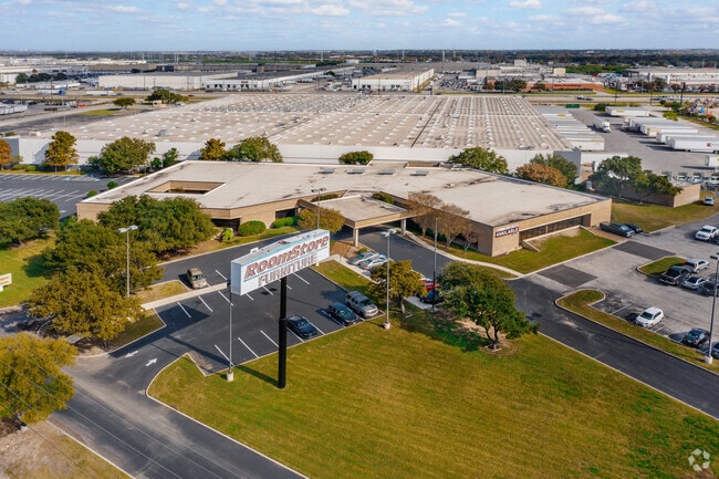
Property Record
4320 N Interstate 35, San Antonio, TX 78218


Save to a Folder
{{folder.Name}}
{{folder.ListingIds.length}} Properties
{{folder.ListingIds.length}} Property
Create a New Folder
Property Detail
4320 N Interstate 35
San Antonio-New Braunfels, TX
NCB 12201 BLK LOT NE IRR 948.07 FT OF 7 2021- RESURVEY PER DEED 20200193623 (21.726 ACRES CONVEYED) EXE 8-21-2020 & NEW PER SPLIT PER DEED 14796/697 FILED 1-3-2011 (.492 ACRES CONVEYED). OUT OF PID 502423. SEE SURVEY MAP ATTACHED (CR 50536). JF/GIS/3
12201-000-0071
BEXAR
Warehouse
Texas
B and X Area of moderate flood hazard, usually the area between the limits of the 100-year and 500-year floods.
71
2025
21.73 AC
2025
Northeast
120502
San Antonio
32,818 SF
NEARBY LISTINGS FOR SALE OR LEASE
DEMOGRAPHICS near 4320 N Interstate 35
1 mile
3 mile
5 mile
2025 Total Population
4,647
77,096
249,024
2030 Population
4,904
80,850
263,334
Pop Growth 2025-2030
+ 5.53%
+ 4.87%
+ 5.75%
Average Age
34
36
37
2025 Total Households
1,322
26,743
93,263
HH Growth 2025-2030
+ 5.30%
+ 4.94%
+ 5.93%
Median Household Inc
$51,149
$61,086
$63,296
Avg Household Size
2.90
2.70
2.50
2025 Avg HH Vehicles
2.00
2.00
2.00
Median Home Value
$146,428
$196,309
$249,980
Median Year Built
1977
1979
1979
Nearby Places
Map Layers
Map Styles
 Street
 Aerial
Layers
 Traffic
 Biking
Places
Listings with unknown addresses are not visible on the map
- Restaurants
- Banks
- Shops
- Fitness
- Groceries
PUBLIC TRANSPORTATION
COMMUTER RAIL
San Antonio Amtrak Station (Sunset Limited - Amtrak, Texas Eagle - Amtrak)
Drive
Walk
Distance
San Antonio Amtrak Station (Sunset Limited - Amtrak, Texas Eagle - Amtrak)
13 min
7.1 mi
AIRPORT
San Antonio International
Drive
Walk
Distance
San Antonio International
14 min
9.8 mi
Freight Ports
Calhoun Port
Drive
Walk
Distance
Calhoun Port
176 min
144.7 mi
SALE & LEASE HISTORY
LISTING DATE
SALE/LEASE

Sep 25, 2016
For Lease
Nov 22, 2017
For Sale
Jul 07, 2017
For Sale
Aug 25, 2020
For Lease
Apr 27, 2023
For Lease
Nearby Properties
Address
Land Use
TOTAL SIZE
Lot Size
Zoning
Address
Land Use
TOTAL SIZE
Lot Size
Zoning
2,544.56 AC
Address
Land Use
TOTAL SIZE
Lot Size
Zoning
1,649,488 SF
70 AC
Address
Land Use
TOTAL SIZE
Lot Size
Zoning
25,513 SF
18.14 AC
Address
Land Use
TOTAL SIZE
Lot Size
Zoning
71,253 SF
25.52 AC
Address
Land Use
TOTAL SIZE
Lot Size
Zoning
278,406 SF
13.39 AC
Address
Land Use
TOTAL SIZE
Lot Size
Zoning
268,495 SF
13.04 AC
Address
Land Use
TOTAL SIZE
Lot Size
Zoning
139,410 SF
35.75 AC
Address
Land Use
TOTAL SIZE
Lot Size
Zoning
598,070 SF
46.05 AC
Address
Land Use
TOTAL SIZE
Lot Size
Zoning
387,440 SF
27.71 AC
Address
Land Use
TOTAL SIZE
Lot Size
Zoning
328,605 SF
25.69 AC
Address
Land Use
TOTAL SIZE
Lot Size
Zoning
273,516 SF
17.50 AC
Address
Land Use
TOTAL SIZE
Lot Size
Zoning
132.44 AC
Address
Land Use
TOTAL SIZE
Lot Size
Zoning
110,252 SF
20.04 AC
Address
Land Use
TOTAL SIZE
Lot Size
Zoning
337,468 SF
21.84 AC
Address
Land Use
TOTAL SIZE
Lot Size
Zoning
300,987 SF
29.07 AC
Address
Land Use
TOTAL SIZE
Lot Size
Zoning
222,865 SF
17.75 AC
Address
Land Use
TOTAL SIZE
Lot Size
Zoning
431,326 SF
42.70 AC
Address
Land Use
TOTAL SIZE
Lot Size
Zoning
300,555 SF
29.35 AC
Address
Land Use
TOTAL SIZE
Lot Size
Zoning
280,365 SF
17.72 AC
Address
Land Use
TOTAL SIZE
Lot Size
Zoning
437,807 SF
24.55 AC
Address
Land Use
TOTAL SIZE
Lot Size
Zoning
391,863 SF
24.43 AC
Address
Land Use
TOTAL SIZE
Lot Size
Zoning
306,000 SF
20.23 AC
Address
Land Use
TOTAL SIZE
Lot Size
Zoning
15.42 AC
Address
Land Use
TOTAL SIZE
Lot Size
Zoning
251,680 SF
15.52 AC
Address
Land Use
TOTAL SIZE
Lot Size
Zoning
25,513 SF
18.14 AC
Address
Land Use
TOTAL SIZE
Lot Size
Zoning
224,840 SF
17.27 AC
Address
Land Use
TOTAL SIZE
Lot Size
Zoning
199,280 SF
11.50 AC
Address
Land Use
TOTAL SIZE
Lot Size
Zoning
362,280 SF
17.84 AC
Address
Land Use
TOTAL SIZE
Lot Size
Zoning
190,357 SF
18.08 AC
Address
Land Use
TOTAL SIZE
Lot Size
Zoning
467,359 SF
34.88 AC
The World's #1 Commercial Real Estate Marketplace
Connect with us
© 2026 CoStar Group
The information above has been obtained from sources believed reliable. While we do not doubt its accuracy we have not verified it and make no guarantee, warranty or representation about it. It is your responsibility to independently confirm its accuracy and completeness. Any projections, opinions, assumptions, or estimates used are for example only and do not represent the current or future performance of the property. The value of this transaction to you depends on tax and other factors which should be evaluated by your tax, financial, and legal advisors. You and your advisors should conduct a careful, independent investigation of the property to determine to your satisfaction the suitability of the property for your needs.