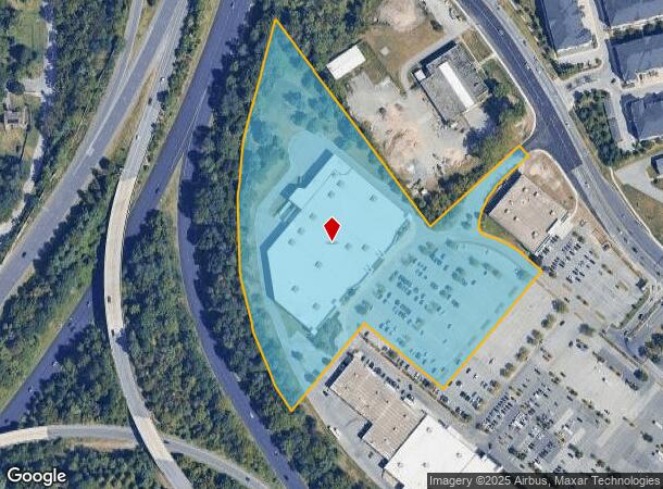
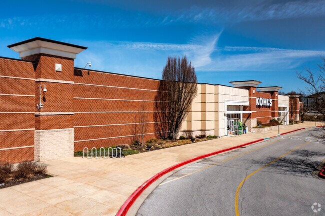
Property Record
4320 Route 100, Ellicott City, MD 21043

NEARBY LISTINGS FOR SALE OR LEASE
Property Detail
4320 Route 100
02-394952
PAR V 10.579 A 4320 ROUTE 100 LONG GATE CTR RSB L
Departmentstore
Howard
X
Maryland
24013C0450D
v
2024
10.58 AC
2025
Columbia North
602800
Baltimore
86,933 SF
Baltimore-Columbia-Towson, MD
DEMOGRAPHICS near 4320 Route 100
1 Mile
3 Mile
5 Mile
2024 Total Population
7,636
80,560
207,239
2029 Population
7,815
82,533
210,885
Pop Growth 2024-2029
+ 2.34%
+ 2.45%
+ 1.76%
Average Age
42
41
40
2024 Total Households
2,736
29,813
77,009
HH Growth 2024-2029
+ 2.34%
+ 2.52%
+ 1.83%
Median Household Inc
$165,695
$132,071
$121,617
Avg Household Size
2.70
2.70
2.60
2024 Avg HH Vehicles
2.00
2.00
2.00
Median Home Value
$639,101
$575,982
$479,566
Median Year Built
1988
1985
1984
Nearby Places
Map Layers
Map Styles
 Street
 Aerial
- Restaurants
- Banks
- Shops
- Fitness
- Groceries
PUBLIC TRANSPORTATION
COMMUTER RAIL
DRIVE
WALK
Distance
15 min
8.5 mi
DRIVE
WALK
Distance
15 min
8.5 mi
AIRPORT
Baltimore/Washington International Thurgood Marshall
DRIVE
WALK
Distance
Baltimore/Washington International Thurgood Marshall
23 min
14.9 mi
Ronald Reagan Washington Ntl
DRIVE
WALK
Distance
Ronald Reagan Washington Ntl
60 min
34.7 mi
Freight Ports
Port of Baltimore
DRIVE
WALK
Distance
Port of Baltimore
27 min
17.5 mi
Nearby Properties
Address
Land Use
TOTAL SIZE
Lot Size
Zoning
Address
Land Use
TOTAL SIZE
Lot Size
Zoning
33,342 SF
94.97 AC
RA15
Address
Land Use
TOTAL SIZE
Lot Size
Zoning
233,265 SF
28.95 AC
NT
Address
Land Use
TOTAL SIZE
Lot Size
Zoning
1,930 SF
49.68 AC
PSC
Address
Land Use
TOTAL SIZE
Lot Size
Zoning
279,539 SF
68.15 AC
R20
Address
Land Use
TOTAL SIZE
Lot Size
Zoning
17,528 SF
20.15 AC
NT
Address
Land Use
TOTAL SIZE
Lot Size
Zoning
48,414 SF
19.18 AC
RA15
Address
Land Use
TOTAL SIZE
Lot Size
Zoning
31,590 SF
18.89 AC
RA15
Address
Land Use
TOTAL SIZE
Lot Size
Zoning
14,040 SF
10.86 AC
RA15
Address
Land Use
TOTAL SIZE
Lot Size
Zoning
309,703 SF
39.71 AC
R20
Address
Land Use
TOTAL SIZE
Lot Size
Zoning
11,244 SF
23.20 AC
NT
Address
Land Use
TOTAL SIZE
Lot Size
Zoning
36,399 SF
25.30 AC
RA15
Address
Land Use
TOTAL SIZE
Lot Size
Zoning
48,168 SF
14.91 AC
RA15
Address
Land Use
TOTAL SIZE
Lot Size
Zoning
237,128 SF
24.77 AC
B2
Address
Land Use
TOTAL SIZE
Lot Size
Zoning
24,716 SF
10.05 AC
NT
Address
Land Use
TOTAL SIZE
Lot Size
Zoning
204,875 SF
5.81 AC
POR
Address
Land Use
TOTAL SIZE
Lot Size
Zoning
132,865 SF
27.08 AC
SC
Address
Land Use
TOTAL SIZE
Lot Size
Zoning
16,651 SF
11.65 AC
NT
Address
Land Use
TOTAL SIZE
Lot Size
Zoning
166,406 SF
11.22 AC
R20
Address
Land Use
TOTAL SIZE
Lot Size
Zoning
58,644 SF
31.75 AC
B2
Address
Land Use
TOTAL SIZE
Lot Size
Zoning
21,726 SF
10.14 AC
NT
Address
Land Use
TOTAL SIZE
Lot Size
Zoning
165,860 SF
3.35 AC
BLCCC
Address
Land Use
TOTAL SIZE
Lot Size
Zoning
117,444 SF
19.97 AC
POR
Address
Land Use
TOTAL SIZE
Lot Size
Zoning
91,716 SF
15.07 AC
POR
Address
Land Use
TOTAL SIZE
Lot Size
Zoning
14,838 SF
14.40 AC
RA15
Address
Land Use
TOTAL SIZE
Lot Size
Zoning
1,163 SF
4.49 AC
TOD
Address
Land Use
TOTAL SIZE
Lot Size
Zoning
6,300 SF
11.10 AC
B2B1
Address
Land Use
TOTAL SIZE
Lot Size
Zoning
117,518 SF
22.27 AC
RSC
Address
Land Use
TOTAL SIZE
Lot Size
Zoning
41,286 SF
12.62 AC
RA15
Address
Land Use
TOTAL SIZE
Lot Size
Zoning
23,932 SF
11.34 AC
RA15
Address
Land Use
TOTAL SIZE
Lot Size
Zoning
225,524 SF
2.94 AC
NT
The World's #1 Commercial Real Estate Marketplace
Connect with us
© 2025 CoStar Group
The information above has been obtained from sources believed reliable. While we do not doubt its accuracy we have not verified it and make no guarantee, warranty or representation about it. It is your responsibility to independently confirm its accuracy and completeness. Any projections, opinions, assumptions, or estimates used are for example only and do not represent the current or future performance of the property. The value of this transaction to you depends on tax and other factors which should be evaluated by your tax, financial, and legal advisors. You and your advisors should conduct a careful, independent investigation of the property to determine to your satisfaction the suitability of the property for your needs.