Property Record
4321 Browns Bridge Rd, Gainesville, GA 30504

NEARBY LISTINGS FOR SALE OR LEASE
-
-
View all Gainesville listings for lease on LoopNet.com
Property Detail
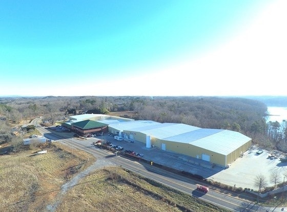
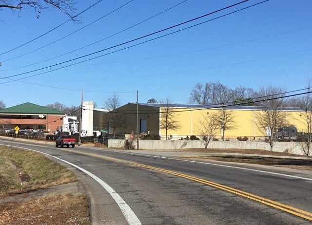
4321 Browns Bridge Rd
08-00057-01-018
Bobby Whitmire S/D
Officebuilding
1276 WESSELL ROAD NW
X
Hall
13139C0170G
Georgia
0
14.72 AC
2025
I-985/Gainesville
000901
Atlanta
178,860 SF
Gainesville, GA
DEMOGRAPHICS near 4321 Browns Bridge Rd
1 Mile
3 Mile
5 Mile
2024 Total Population
1,587
23,302
65,784
2029 Population
1,776
26,271
74,081
Pop Growth 2024-2029
+ 11.91%
+ 12.74%
+ 12.61%
Average Age
45
42
39
2024 Total Households
614
8,697
23,425
HH Growth 2024-2029
+ 11.89%
+ 12.71%
+ 12.65%
Median Household Inc
$49,586
$68,944
$67,349
Avg Household Size
2.50
2.60
2.70
2024 Avg HH Vehicles
2.00
2.00
2.00
Median Home Value
$448,823
$292,417
$298,479
Median Year Built
1985
1995
1994
Nearby Places
Map Layers
Map Styles
 Street
 Aerial
- Restaurants
- Banks
- Shops
- Fitness
- Groceries
PUBLIC TRANSPORTATION
COMMUTER RAIL
Gainesville Amtrak Station (Crescent - Amtrak)
DRIVE
WALK
Distance
Gainesville Amtrak Station (Crescent - Amtrak)
12 min
6.7 mi
Freight Ports
Georgia Ports - Savannah
DRIVE
WALK
Distance
Georgia Ports - Savannah
327 min
257.3 mi
SALE & LEASE HISTORY
LISTING DATE
SALE/LEASE

Jul 18, 2019
For Lease
Feb 02, 2018
For Sale
Nearby Properties
Address
Land Use
TOTAL SIZE
Lot Size
Zoning
Address
Land Use
TOTAL SIZE
Lot Size
Zoning
157,050 SF
144.96 AC
N-B
Address
Land Use
TOTAL SIZE
Lot Size
Zoning
92,448 SF
24.25 AC
PUD
Address
Land Use
TOTAL SIZE
Lot Size
Zoning
342,720 SF
22.95 AC
PUD
Address
Land Use
TOTAL SIZE
Lot Size
Zoning
1,580 SF
15.85 AC
PUD
Address
Land Use
TOTAL SIZE
Lot Size
Zoning
132,557 SF
32.85 AC
O-I
Address
Land Use
TOTAL SIZE
Lot Size
Zoning
308,672 SF
41.22 AC
L-I
Address
Land Use
TOTAL SIZE
Lot Size
Zoning
67,718 SF
27.31 AC
PUD
Address
Land Use
TOTAL SIZE
Lot Size
Zoning
68,214 SF
10.85 AC
O-I
Address
Land Use
TOTAL SIZE
Lot Size
Zoning
10,050 SF
9.60 AC
C-2
Address
Land Use
TOTAL SIZE
Lot Size
Zoning
42,288 SF
5.57 AC
R-B
Address
Land Use
TOTAL SIZE
Lot Size
Zoning
14,848 SF
7.76 AC
PRD
Address
Land Use
TOTAL SIZE
Lot Size
Zoning
28,260 SF
19.13 AC
PUD
Address
Land Use
TOTAL SIZE
Lot Size
Zoning
8,160 SF
7.46 AC
R-4
Address
Land Use
TOTAL SIZE
Lot Size
Zoning
24,000 SF
11.36 AC
PCD
Address
Land Use
TOTAL SIZE
Lot Size
Zoning
13.54 AC
G-B
Address
Land Use
TOTAL SIZE
Lot Size
Zoning
15,400 SF
6.05 AC
G-B
Address
Land Use
TOTAL SIZE
Lot Size
Zoning
1,600 SF
0.52 AC
V-C
Address
Land Use
TOTAL SIZE
Lot Size
Zoning
560 SF
19.45 AC
R-1
Address
Land Use
TOTAL SIZE
Lot Size
Zoning
18,116 SF
3.97 AC
C-2
Address
Land Use
TOTAL SIZE
Lot Size
Zoning
37,590 SF
2.64 AC
C-2
Address
Land Use
TOTAL SIZE
Lot Size
Zoning
7,440 SF
11.86 AC
H-B
Address
Land Use
TOTAL SIZE
Lot Size
Zoning
21,961 SF
3.35 AC
G-B
Address
Land Use
TOTAL SIZE
Lot Size
Zoning
1,320 SF
5.13 AC
C-2
Address
Land Use
TOTAL SIZE
Lot Size
Zoning
15.69 AC
O-I
Address
Land Use
TOTAL SIZE
Lot Size
Zoning
988 SF
7.99 AC
G-B
Address
Land Use
TOTAL SIZE
Lot Size
Zoning
5,196 SF
2.93 AC
PUD
Address
Land Use
TOTAL SIZE
Lot Size
Zoning
23,350 SF
3.06 AC
H-B
Address
Land Use
TOTAL SIZE
Lot Size
Zoning
104.80 AC
PUD
Address
Land Use
TOTAL SIZE
Lot Size
Zoning
9,000 SF
2.12 AC
G-B
The World's #1 Commercial Real Estate Marketplace
Connect with us
© 2026 CoStar Group
The information above has been obtained from sources believed reliable. While we do not doubt its accuracy we have not verified it and make no guarantee, warranty or representation about it. It is your responsibility to independently confirm its accuracy and completeness. Any projections, opinions, assumptions, or estimates used are for example only and do not represent the current or future performance of the property. The value of this transaction to you depends on tax and other factors which should be evaluated by your tax, financial, and legal advisors. You and your advisors should conduct a careful, independent investigation of the property to determine to your satisfaction the suitability of the property for your needs.