Property Record
4321 Highway 35 N, Rockport, TX 78382

Property Detail
4321 Highway 35 N
R70972
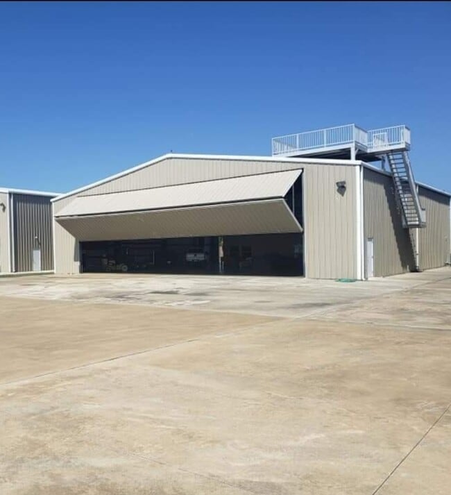
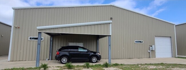
IMPROVEMENTS AT ARANSAS COUNTY AIRPORT, HANGER AND LAND LEASEHOLD
Commercialnec
ARANSAS
B and X Area of moderate flood hazard, usually the area between the limits of the 100-year and 500-year floods.
Texas
2025
15.86 AC
2025
Rockport/N Aransas
950302
Corpus Christi
6,400 SF
Corpus Christi, TX
NEARBY LISTINGS FOR SALE OR LEASE
-
-
View all Rockport listings for sale on LoopNet.com
DEMOGRAPHICS near 4321 Highway 35 N
1 mile
3 mile
5 mile
2024 Total Population
407
7,750
17,459
2029 Population
452
9,087
20,871
Pop Growth 2024-2029
+ 11.06%
+ 17.25%
+ 19.54%
Average Age
53
52
49
2024 Total Households
207
3,694
7,792
HH Growth 2024-2029
+ 13.53%
+ 19.27%
+ 21.45%
Median Household Inc
$74,166
$74,237
$65,158
Avg Household Size
1.90
2.00
2.20
2024 Avg HH Vehicles
2.00
2.00
2.00
Median Home Value
$291,110
$335,991
$287,519
Median Year Built
1985
1995
1993
Nearby Places
Map Layers
Map Styles
 Street
 Aerial
Transit
 Traffic
 Biking
Places
Listings with unknown addresses are not visible on the map
- Restaurants
- Banks
- Shops
- Fitness
- Groceries
PUBLIC TRANSPORTATION
AIRPORT
Corpus Christi International
Drive
Walk
Distance
Corpus Christi International
54 min
42.1 mi
Freight Ports
Port of Corpus Christi
Drive
Walk
Distance
Port of Corpus Christi
40 min
33.7 mi
SALE & LEASE HISTORY
LISTING DATE
SALE/LEASE

Jun 16, 2025
For Sale
Nearby Properties
Address
Land Use
TOTAL SIZE
Lot Size
Zoning
Address
Land Use
TOTAL SIZE
Lot Size
Zoning
395,335 SF
57.39 AC
Address
Land Use
TOTAL SIZE
Lot Size
Zoning
100,891 SF
7.78 AC
Address
Land Use
TOTAL SIZE
Lot Size
Zoning
32,302 SF
14.42 AC
Address
Land Use
TOTAL SIZE
Lot Size
Zoning
125,197 SF
14.61 AC
Address
Land Use
TOTAL SIZE
Lot Size
Zoning
79,033 SF
649.69 AC
Address
Land Use
TOTAL SIZE
Lot Size
Zoning
75,772 SF
13.74 AC
Address
Land Use
TOTAL SIZE
Lot Size
Zoning
126,886 AC
Address
Land Use
TOTAL SIZE
Lot Size
Zoning
288 SF
129.13 AC
Address
Land Use
TOTAL SIZE
Lot Size
Zoning
47,169 SF
85.55 AC
Address
Land Use
TOTAL SIZE
Lot Size
Zoning
33,524 SF
2.06 AC
Address
Land Use
TOTAL SIZE
Lot Size
Zoning
155,264 SF
21.60 AC
Address
Land Use
TOTAL SIZE
Lot Size
Zoning
18,998 SF
20 AC
Address
Land Use
TOTAL SIZE
Lot Size
Zoning
2,980 SF
47.98 AC
Address
Land Use
TOTAL SIZE
Lot Size
Zoning
59,220 AC
Address
Land Use
TOTAL SIZE
Lot Size
Zoning
152.58 AC
Address
Land Use
TOTAL SIZE
Lot Size
Zoning
91,025 SF
8.22 AC
Address
Land Use
TOTAL SIZE
Lot Size
Zoning
16,791 SF
2.65 AC
Address
Land Use
TOTAL SIZE
Lot Size
Zoning
14,925 SF
1.66 AC
Address
Land Use
TOTAL SIZE
Lot Size
Zoning
68,265 SF
8.15 AC
Address
Land Use
TOTAL SIZE
Lot Size
Zoning
9,886 SF
7.96 AC
Address
Land Use
TOTAL SIZE
Lot Size
Zoning
12,072 SF
126.99 AC
Address
Land Use
TOTAL SIZE
Lot Size
Zoning
13,518 SF
1.82 AC
Address
Land Use
TOTAL SIZE
Lot Size
Zoning
2,739 SF
117.62 AC
Address
Land Use
TOTAL SIZE
Lot Size
Zoning
17,370 SF
10.10 AC
Address
Land Use
TOTAL SIZE
Lot Size
Zoning
15,600 SF
3.11 AC
Address
Land Use
TOTAL SIZE
Lot Size
Zoning
21,676 SF
6.87 AC
Address
Land Use
TOTAL SIZE
Lot Size
Zoning
70,416 SF
7.53 AC
Address
Land Use
TOTAL SIZE
Lot Size
Zoning
Address
Land Use
TOTAL SIZE
Lot Size
Zoning
30,664 AC
Address
Land Use
TOTAL SIZE
Lot Size
Zoning
17,682 SF
1.51 AC
The World's #1 Commercial Real Estate Marketplace
Connect with us
© 2026 CoStar Group
The information above has been obtained from sources believed reliable. While we do not doubt its accuracy we have not verified it and make no guarantee, warranty or representation about it. It is your responsibility to independently confirm its accuracy and completeness. Any projections, opinions, assumptions, or estimates used are for example only and do not represent the current or future performance of the property. The value of this transaction to you depends on tax and other factors which should be evaluated by your tax, financial, and legal advisors. You and your advisors should conduct a careful, independent investigation of the property to determine to your satisfaction the suitability of the property for your needs.