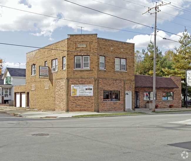
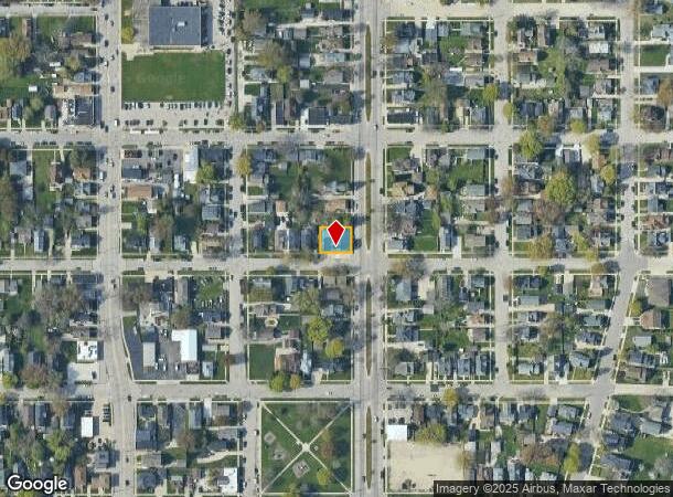
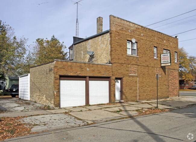
Property Record
4324 7Th Ave, Kenosha, WI 53140
NEARBY LISTINGS FOR SALE OR LEASE
Property Detail
4324 7Th Ave
Chicago-Naperville-Elgin, IL-IN-WI
Original T
11-223-30-461-009
PT OF BLK 32 SE 1/4 SEC 30 T2 R23 COM AT NW COR OF 7TH AVE & 44 ST TH N 66 FT W 80 FT S 66 FT E 80 FT TO BEG DOC#1163045 DOC#
Commercialnec
Kenosha
X
Wisconsin
55059C0202E
0
2024
0.12 AC
2024
Kenosha East
000300
Chicago
3,858 SF
DEMOGRAPHICS near 4324 7Th Ave
1 Mile
3 Mile
5 Mile
2024 Total Population
11,817
70,767
101,571
2029 Population
11,539
69,705
100,506
Pop Growth 2024-2029
(2.35%)
(1.50%)
(1.05%)
Average Age
37
38
39
2024 Total Households
4,637
28,315
40,740
HH Growth 2024-2029
(2.16%)
(1.42%)
(1.03%)
Median Household Inc
$46,995
$58,747
$63,801
Avg Household Size
2.20
2.30
2.30
2024 Avg HH Vehicles
2.00
2.00
2.00
Median Home Value
$167,360
$174,859
$196,901
Median Year Built
1950
1961
1968
Nearby Places
Map Layers
Map Styles
 Street
 Aerial
- Restaurants
- Banks
- Shops
- Fitness
- Groceries
PUBLIC TRANSPORTATION
TRANSIT/SUBWAY
Kenosha Station (Union Pacific North Line - Northeast Illinois Regional Commuter Railroad (Metra))
DRIVE
WALK
Distance
Kenosha Station (Union Pacific North Line - Northeast Illinois Regional Commuter Railroad (Metra))
3 min
18 min
0.9 mi
COMMUTER RAIL
Kenosha Station (Union Pacific North Line - Northeast Illinois Regional Commuter Railroad (Metra))
DRIVE
WALK
Distance
Kenosha Station (Union Pacific North Line - Northeast Illinois Regional Commuter Railroad (Metra))
3 min
18 min
0.9 mi
Winthrop Harbor Station (Union Pacific North Line - Northeast Illinois Regional Commuter Railroad (Metra))
DRIVE
WALK
Distance
Winthrop Harbor Station (Union Pacific North Line - Northeast Illinois Regional Commuter Railroad (Metra))
16 min
8.4 mi
AIRPORT
General Mitchell International
DRIVE
WALK
Distance
General Mitchell International
44 min
31.9 mi
Freight Ports
Port Milwaukee
DRIVE
WALK
Distance
Port Milwaukee
49 min
35.8 mi
SALE & LEASE HISTORY
LISTING DATE
SALE/LEASE

Aug 01, 2017
For Sale
Nearby Properties
Address
Land Use
TOTAL SIZE
Lot Size
Zoning
Address
Land Use
TOTAL SIZE
Lot Size
Zoning
30.04 AC
Address
Land Use
TOTAL SIZE
Lot Size
Zoning
183,173 SF
9.73 AC
RM3
Address
Land Use
TOTAL SIZE
Lot Size
Zoning
16,466 SF
19.09 AC
RM2
Address
Land Use
TOTAL SIZE
Lot Size
Zoning
32,245 SF
22 AC
RM2
Address
Land Use
TOTAL SIZE
Lot Size
Zoning
21,072 SF
24.33 AC
RM2
Address
Land Use
TOTAL SIZE
Lot Size
Zoning
26,016 SF
14.02 AC
FW
Address
Land Use
TOTAL SIZE
Lot Size
Zoning
26,500 SF
17.79 AC
RM2
Address
Land Use
TOTAL SIZE
Lot Size
Zoning
10.37 AC
IP
Address
Land Use
TOTAL SIZE
Lot Size
Zoning
357,885 SF
26.58 AC
M1
Address
Land Use
TOTAL SIZE
Lot Size
Zoning
88,473 SF
8.98 AC
B2
Address
Land Use
TOTAL SIZE
Lot Size
Zoning
76,848 SF
8.09 AC
BASE
Address
Land Use
TOTAL SIZE
Lot Size
Zoning
28,815 SF
1.04 AC
B3
Address
Land Use
TOTAL SIZE
Lot Size
Zoning
0.62 AC
Address
Land Use
TOTAL SIZE
Lot Size
Zoning
12.38 AC
M1
Address
Land Use
TOTAL SIZE
Lot Size
Zoning
63,500 SF
5.81 AC
RM2
Address
Land Use
TOTAL SIZE
Lot Size
Zoning
147,040 SF
2.50 AC
RM2
Address
Land Use
TOTAL SIZE
Lot Size
Zoning
59,660 SF
1.22 AC
RM3
Address
Land Use
TOTAL SIZE
Lot Size
Zoning
84,950 SF
8.11 AC
Address
Land Use
TOTAL SIZE
Lot Size
Zoning
31,650 SF
7.62 AC
FW
Address
Land Use
TOTAL SIZE
Lot Size
Zoning
319,640 SF
19.20 AC
M1
Address
Land Use
TOTAL SIZE
Lot Size
Zoning
9,860 SF
14.55 AC
RM2
Address
Land Use
TOTAL SIZE
Lot Size
Zoning
88,867 SF
8.32 AC
B2
Address
Land Use
TOTAL SIZE
Lot Size
Zoning
32,000 SF
3.97 AC
IP
Address
Land Use
TOTAL SIZE
Lot Size
Zoning
116,227 SF
10.60 AC
B2
Address
Land Use
TOTAL SIZE
Lot Size
Zoning
3.72 AC
Address
Land Use
TOTAL SIZE
Lot Size
Zoning
6.03 AC
M2
Address
Land Use
TOTAL SIZE
Lot Size
Zoning
49,528 SF
4.73 AC
B2
Address
Land Use
TOTAL SIZE
Lot Size
Zoning
25,164 SF
3.21 AC
RM2
Address
Land Use
TOTAL SIZE
Lot Size
Zoning
45,608 SF
1.31 AC
IP
Address
Land Use
TOTAL SIZE
Lot Size
Zoning
89,436 SF
4.53 AC
RM2
The World's #1 Commercial Real Estate Marketplace
Connect with us
© 2025 CoStar Group
The information above has been obtained from sources believed reliable. While we do not doubt its accuracy we have not verified it and make no guarantee, warranty or representation about it. It is your responsibility to independently confirm its accuracy and completeness. Any projections, opinions, assumptions, or estimates used are for example only and do not represent the current or future performance of the property. The value of this transaction to you depends on tax and other factors which should be evaluated by your tax, financial, and legal advisors. You and your advisors should conduct a careful, independent investigation of the property to determine to your satisfaction the suitability of the property for your needs.