Property Record
4325 State Road 60 W, Mulberry, FL 33860
NEARBY LISTINGS FOR SALE OR LEASE
-
-
View all Mulberry listings for sale on LoopNet.com
Property Detail
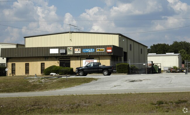
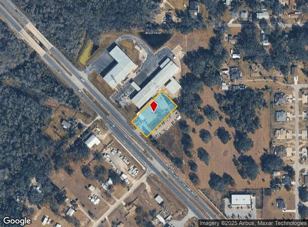
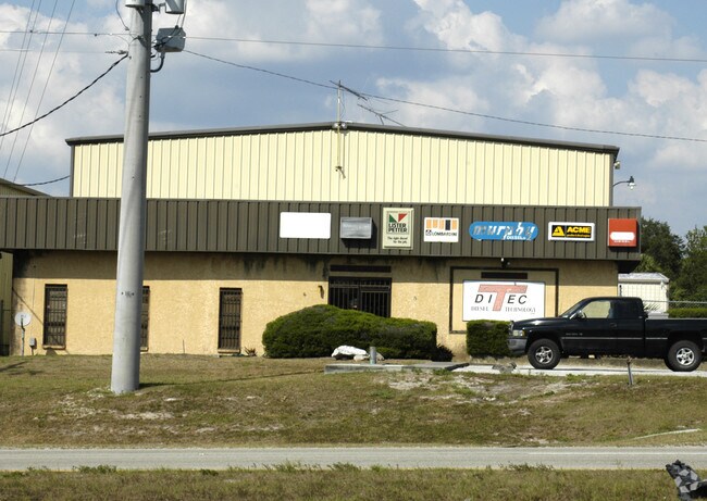
4325 State Road 60 W
Lakeland-Winter Haven, FL
Alderman J M
23-29-32-000000-013220
COMM NE COR NW1/4 OF NE1/4 RUN W 205 FT S 574.87 FT N 44 DEG 50 W 82.9 FT TO POB CONT N 44 DEG 50 W 150 FT S 45 DEG 10 W 299.59 FT TO NELY R/W SR 60 SELY ALONG SAID R/W 150 FT N 45 DEG 10 E 299.7 FT TO POB BEING LOT 27 OF UNRE SABAL SQUARE
Warehouse
Polk
X
Florida
12105C0470G
27
2024
1.02 AC
2025
Polk County
014905
Tampa/St Petersburg
9,000 SF
DEMOGRAPHICS near 4325 State Road 60 W
1 Mile
3 Mile
5 Mile
2024 Total Population
5,359
28,986
58,064
2029 Population
6,377
34,337
68,373
Pop Growth 2024-2029
+ 19.00%
+ 18.46%
+ 17.75%
Average Age
34
37
39
2024 Total Households
1,614
10,046
20,836
HH Growth 2024-2029
+ 18.96%
+ 18.37%
+ 17.85%
Median Household Inc
$48,359
$66,302
$69,158
Avg Household Size
3.10
2.80
2.70
2024 Avg HH Vehicles
2.00
2.00
2.00
Median Home Value
$194,671
$231,097
$243,036
Median Year Built
1990
1993
1992
Nearby Places
Map Layers
Map Styles
 Street
 Aerial
- Restaurants
- Banks
- Shops
- Fitness
- Groceries
SALE & LEASE HISTORY
LISTING DATE
SALE/LEASE

Sep 23, 2016
For Sale
Nearby Properties
Address
Land Use
TOTAL SIZE
Lot Size
Zoning
Address
Land Use
TOTAL SIZE
Lot Size
Zoning
882,663 SF
133.57 AC
PUD
Address
Land Use
TOTAL SIZE
Lot Size
Zoning
306,126 SF
25.03 AC
Address
Land Use
TOTAL SIZE
Lot Size
Zoning
145,672 SF
16 AC
Address
Land Use
TOTAL SIZE
Lot Size
Zoning
266,502 SF
51.06 AC
RC
Address
Land Use
TOTAL SIZE
Lot Size
Zoning
81,706 SF
20.35 AC
Address
Land Use
TOTAL SIZE
Lot Size
Zoning
66,800 SF
8.65 AC
Address
Land Use
TOTAL SIZE
Lot Size
Zoning
20,000 SF
337.40 AC
AM
Address
Land Use
TOTAL SIZE
Lot Size
Zoning
104,418 SF
20.10 AC
Address
Land Use
TOTAL SIZE
Lot Size
Zoning
79,100 SF
4.72 AC
PUD
Address
Land Use
TOTAL SIZE
Lot Size
Zoning
48,882 SF
21.62 AC
Address
Land Use
TOTAL SIZE
Lot Size
Zoning
1,248 SF
229.47 AC
AM
Address
Land Use
TOTAL SIZE
Lot Size
Zoning
59,860 SF
10.48 AC
GI
Address
Land Use
TOTAL SIZE
Lot Size
Zoning
14,835 SF
8.96 AC
C2
Address
Land Use
TOTAL SIZE
Lot Size
Zoning
24,988 SF
8.28 AC
Address
Land Use
TOTAL SIZE
Lot Size
Zoning
16,955 SF
2.65 AC
Address
Land Use
TOTAL SIZE
Lot Size
Zoning
4,778 SF
118.98 AC
AR
Address
Land Use
TOTAL SIZE
Lot Size
Zoning
73.52 AC
Address
Land Use
TOTAL SIZE
Lot Size
Zoning
11,376 SF
65.40 AC
Address
Land Use
TOTAL SIZE
Lot Size
Zoning
103,151 SF
20.86 AC
Address
Land Use
TOTAL SIZE
Lot Size
Zoning
62,613 SF
10.02 AC
GI
Address
Land Use
TOTAL SIZE
Lot Size
Zoning
86,860 SF
3.02 AC
GI
Address
Land Use
TOTAL SIZE
Lot Size
Zoning
17,166 SF
2.72 AC
Address
Land Use
TOTAL SIZE
Lot Size
Zoning
86.26 AC
AR
Address
Land Use
TOTAL SIZE
Lot Size
Zoning
103,412 SF
65.26 AC
Address
Land Use
TOTAL SIZE
Lot Size
Zoning
29,941 SF
5.06 AC
Address
Land Use
TOTAL SIZE
Lot Size
Zoning
8,544 SF
13.90 AC
Address
Land Use
TOTAL SIZE
Lot Size
Zoning
25,500 SF
1.50 AC
GI
Address
Land Use
TOTAL SIZE
Lot Size
Zoning
13,020 SF
2.27 AC
XX
Address
Land Use
TOTAL SIZE
Lot Size
Zoning
9,165 SF
6.24 AC
Address
Land Use
TOTAL SIZE
Lot Size
Zoning
29,416 SF
49.71 AC
The World's #1 Commercial Real Estate Marketplace
Connect with us
© 2025 CoStar Group
The information above has been obtained from sources believed reliable. While we do not doubt its accuracy we have not verified it and make no guarantee, warranty or representation about it. It is your responsibility to independently confirm its accuracy and completeness. Any projections, opinions, assumptions, or estimates used are for example only and do not represent the current or future performance of the property. The value of this transaction to you depends on tax and other factors which should be evaluated by your tax, financial, and legal advisors. You and your advisors should conduct a careful, independent investigation of the property to determine to your satisfaction the suitability of the property for your needs.