Property Record
43254 52Nd St W, Lancaster, CA 93536
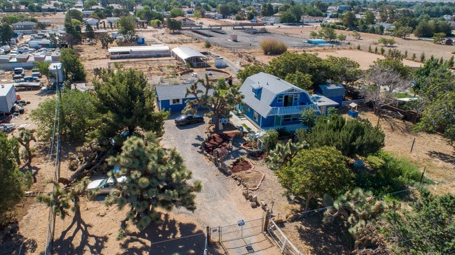
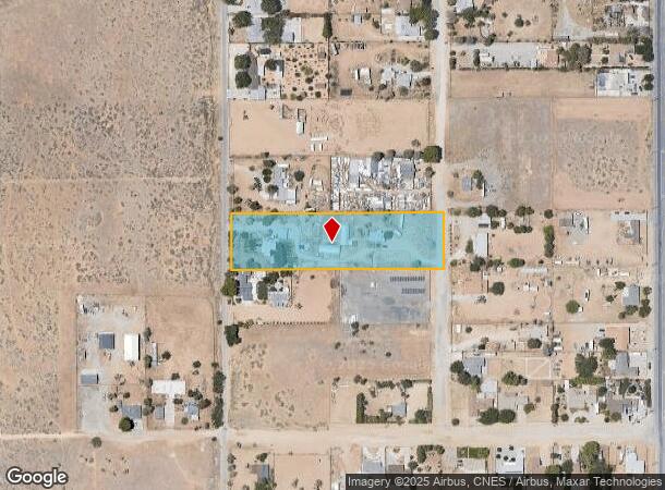
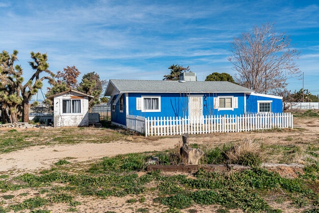
This Property Is For Sale
NEARBY LISTINGS FOR SALE OR LEASE
-
-
View all Lancaster listings for sale on LoopNet.com
Property Detail
43254 52Nd St W
3204-011-016
N 1/2 OF N 1/2 OF SW 1/4 OF SE 1/4 OF NE 1/4 (EX OF ST) OF SEC 26 T 7N R 13W
Sfr
Los Angeles
X
California
06037C0415F
26
2024
2.39 AC
2025
Outlying LA County
901101
Los Angeles
1,620 SF
Los Angeles-Long Beach-Glendale, CA
DEMOGRAPHICS near 43254 52Nd St W
1 mile
3 mile
5 mile
2024 Total Population
7,281
63,746
123,169
2029 Population
7,065
61,908
119,707
Pop Growth 2024-2029
(2.97%)
(2.88%)
(2.81%)
Average Age
36
39
39
2024 Total Households
2,132
20,569
41,278
HH Growth 2024-2029
(3.33%)
(3.16%)
(3.03%)
Median Household Inc
$101,279
$96,425
$79,894
Avg Household Size
3.20
3.00
2.90
2024 Avg HH Vehicles
3.00
2.00
2.00
Median Home Value
$452,537
$442,381
$419,899
Median Year Built
1994
1990
1987
Nearby Places
Map Layers
Map Styles
 Street
 Aerial
Transit
 Traffic
 Biking
Places
Listings with unknown addresses are not visible on the map
- Restaurants
- Banks
- Shops
- Fitness
- Groceries
PUBLIC TRANSPORTATION
COMMUTER RAIL
Lancaster (Antelope Valley Line - Southern California Regional Rail Authority (Metrolink))
Drive
Walk
Distance
Lancaster (Antelope Valley Line - Southern California Regional Rail Authority (Metrolink))
12 min
6.8 mi
Nearby Properties
Address
Land Use
TOTAL SIZE
Lot Size
Zoning
Address
Land Use
TOTAL SIZE
Lot Size
Zoning
107,924 SF
8.95 AC
LRRPD10000
Address
Land Use
TOTAL SIZE
Lot Size
Zoning
58,043 SF
5.94 AC
PDC3
Address
Land Use
TOTAL SIZE
Lot Size
Zoning
146,468 SF
7.41 AC
LRA22*
Address
Land Use
TOTAL SIZE
Lot Size
Zoning
62,739 SF
18.53 AC
LRA22
Address
Land Use
TOTAL SIZE
Lot Size
Zoning
46,328 SF
4.78 AC
LCR1 10000
Address
Land Use
TOTAL SIZE
Lot Size
Zoning
0.34 AC
LCA22*
Address
Land Use
TOTAL SIZE
Lot Size
Zoning
94,491 SF
9.57 AC
LRMDRI
Address
Land Use
TOTAL SIZE
Lot Size
Zoning
32.02 AC
LRSP
Address
Land Use
TOTAL SIZE
Lot Size
Zoning
47,294 SF
4.45 AC
LRR315U*
Address
Land Use
TOTAL SIZE
Lot Size
Zoning
41,550 SF
6.36 AC
LRRA10000*
Address
Land Use
TOTAL SIZE
Lot Size
Zoning
67,985 SF
3.34 AC
LCRA10000*
Address
Land Use
TOTAL SIZE
Lot Size
Zoning
43,255 SF
3.92 AC
LRC1DP*
Address
Land Use
TOTAL SIZE
Lot Size
Zoning
57,126 SF
4.78 AC
LRSP8101*
Address
Land Use
TOTAL SIZE
Lot Size
Zoning
13,565 SF
1.14 AC
PDLCC
Address
Land Use
TOTAL SIZE
Lot Size
Zoning
221,325 SF
4.19 AC
LRA22*
Address
Land Use
TOTAL SIZE
Lot Size
Zoning
36,115 SF
13.25 AC
LCA210
Address
Land Use
TOTAL SIZE
Lot Size
Zoning
105,077 SF
13.27 AC
LCC1-LCR3*
Address
Land Use
TOTAL SIZE
Lot Size
Zoning
23,581 SF
4.81 AC
LRA22*
Address
Land Use
TOTAL SIZE
Lot Size
Zoning
72,584 SF
2.01 AC
LCR1 10000
Address
Land Use
TOTAL SIZE
Lot Size
Zoning
10,000 SF
1.48 AC
LCC2
Address
Land Use
TOTAL SIZE
Lot Size
Zoning
105,212 SF
19.15 AC
LRSRR*
Address
Land Use
TOTAL SIZE
Lot Size
Zoning
27,821 SF
1.09 AC
LCR3P*
Address
Land Use
TOTAL SIZE
Lot Size
Zoning
27,938 SF
3.81 AC
LRRA10000*
Address
Land Use
TOTAL SIZE
Lot Size
Zoning
2.37 AC
LRMDR*
Address
Land Use
TOTAL SIZE
Lot Size
Zoning
63,960 SF
2.37 AC
LRMDR*
Address
Land Use
TOTAL SIZE
Lot Size
Zoning
41,990 SF
1.21 AC
LCR1 10000
Address
Land Use
TOTAL SIZE
Lot Size
Zoning
15,108 SF
1.91 AC
LRCPD*
Address
Land Use
TOTAL SIZE
Lot Size
Zoning
138,009 SF
12.01 AC
LCR3*
Address
Land Use
TOTAL SIZE
Lot Size
Zoning
44,160 SF
5.51 AC
LCR3-2DU-D
Address
Land Use
TOTAL SIZE
Lot Size
Zoning
5,135 SF
19.82 AC
LCA110000*
The World's #1 Commercial Real Estate Marketplace
Connect with us
© 2026 CoStar Group
The information above has been obtained from sources believed reliable. While we do not doubt its accuracy we have not verified it and make no guarantee, warranty or representation about it. It is your responsibility to independently confirm its accuracy and completeness. Any projections, opinions, assumptions, or estimates used are for example only and do not represent the current or future performance of the property. The value of this transaction to you depends on tax and other factors which should be evaluated by your tax, financial, and legal advisors. You and your advisors should conduct a careful, independent investigation of the property to determine to your satisfaction the suitability of the property for your needs.