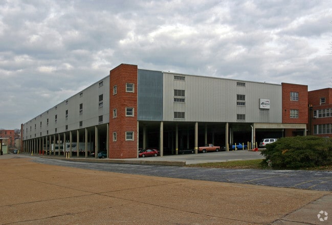
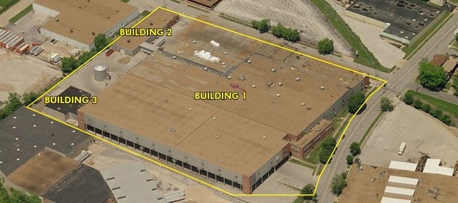
Property Record
4327 Gustine Ave, Saint Louis, MO 63116


Current Lease Availabilities
Property Detail
4327 Gustine Ave
9040-00-0021-0
O.L. 40 BINGHAM 8.755 ACS BINGHAM EST ADDN LOTS 20-21-24 7 W-17 & LOT ADJ SOUTH
Commercialnec
Saint Louis City
K
Missouri
B and X Area of moderate flood hazard, usually the area between the limits of the 100-year and 500-year floods.
20-21
2024
8.76 AC
2025
St Louis City
115300
St. Louis
655,059 SF
St. Louis, MO-IL
NEARBY LISTINGS FOR SALE OR LEASE
DEMOGRAPHICS near 4327 Gustine Ave
1 mile
3 mile
5 mile
2025 Total Population
25,744
134,501
290,397
2030 Population
24,014
126,194
278,077
Pop Growth 2025-2030
(6.72%)
(6.18%)
(4.24%)
Average Age
39
40
40
2025 Total Households
11,343
63,767
138,081
HH Growth 2025-2030
(7.22%)
(6.74%)
(4.79%)
Median Household Inc
$49,590
$67,283
$67,416
Avg Household Size
2.20
2.00
2.00
2025 Avg HH Vehicles
1.00
1.00
1.00
Median Home Value
$147,459
$220,507
$220,320
Median Year Built
1946
1946
1948
Nearby Places
Map Layers
Map Styles
 Street
 Aerial
Layers
 Traffic
 Biking
Places
Listings with unknown addresses are not visible on the map
- Restaurants
- Banks
- Shops
- Fitness
- Groceries
PUBLIC TRANSPORTATION
COMMUTER RAIL
Grand (Lambert Airport Shiloh-Scott - St. Louis MetroLink (MetroLink), Shrewsbury-Lansdowne I-44 Emerson Park - St. Louis MetroLink (MetroLink))
Drive
Walk
Distance
Grand (Lambert Airport Shiloh-Scott - St. Louis MetroLink (MetroLink), Shrewsbury-Lansdowne I-44 Emerson Park - St. Louis MetroLink (MetroLink))
8 min
3.9 mi
Shrewsbury-Lansdowne (Shrewsbury-Lansdowne I-44 Emerson Park - St. Louis MetroLink (MetroLink))
Drive
Walk
Distance
Shrewsbury-Lansdowne (Shrewsbury-Lansdowne I-44 Emerson Park - St. Louis MetroLink (MetroLink))
11 min
4.2 mi
AIRPORT
St Louis Lambert International
Drive
Walk
Distance
St Louis Lambert International
30 min
18.2 mi
Scott AFB/Midamerica St Louis
Drive
Walk
Distance
Scott AFB/Midamerica St Louis
48 min
30.8 mi
Freight Ports
Port Milwaukee
Drive
Walk
Distance
Port Milwaukee
427 min
375.1 mi
Nearby Properties
Address
Land Use
TOTAL SIZE
Lot Size
Zoning
Address
Land Use
TOTAL SIZE
Lot Size
Zoning
0.92 AC
A
Address
Land Use
TOTAL SIZE
Lot Size
Zoning
5.61 AC
A
Address
Land Use
TOTAL SIZE
Lot Size
Zoning
229.57 AC
B
Address
Land Use
TOTAL SIZE
Lot Size
Zoning
177.77 AC
A
Address
Land Use
TOTAL SIZE
Lot Size
Zoning
246,345 SF
4.17 AC
J
Address
Land Use
TOTAL SIZE
Lot Size
Zoning
1.98 AC
H
Address
Land Use
TOTAL SIZE
Lot Size
Zoning
57.77 AC
A
Address
Land Use
TOTAL SIZE
Lot Size
Zoning
628,939 SF
2.73 AC
J
Address
Land Use
TOTAL SIZE
Lot Size
Zoning
2.03 AC
HC
Address
Land Use
TOTAL SIZE
Lot Size
Zoning
275,012 SF
4.39 AC
C
Address
Land Use
TOTAL SIZE
Lot Size
Zoning
467,800 SF
1.30 AC
K
Address
Land Use
TOTAL SIZE
Lot Size
Zoning
22.44 AC
A
Address
Land Use
TOTAL SIZE
Lot Size
Zoning
432,844 SF
5.08 AC
JK
Address
Land Use
TOTAL SIZE
Lot Size
Zoning
220,982 SF
2.83 AC
HB
Address
Land Use
TOTAL SIZE
Lot Size
Zoning
39,863 SF
5.83 AC
H
Address
Land Use
TOTAL SIZE
Lot Size
Zoning
23.21 AC
A
Address
Land Use
TOTAL SIZE
Lot Size
Zoning
114,000 SF
1.25 AC
J
Address
Land Use
TOTAL SIZE
Lot Size
Zoning
261,362 SF
17.19 AC
R6
Address
Land Use
TOTAL SIZE
Lot Size
Zoning
50.67 AC
A
Address
Land Use
TOTAL SIZE
Lot Size
Zoning
433,028 SF
32.35 AC
A
Address
Land Use
TOTAL SIZE
Lot Size
Zoning
268,051 SF
2.37 AC
J
Address
Land Use
TOTAL SIZE
Lot Size
Zoning
35,372 SF
1.78 AC
C
Address
Land Use
TOTAL SIZE
Lot Size
Zoning
124,541 SF
13.07 AC
G
Address
Land Use
TOTAL SIZE
Lot Size
Zoning
54,790 SF
0.87 AC
B
Address
Land Use
TOTAL SIZE
Lot Size
Zoning
122,278 SF
10.83 AC
F
Address
Land Use
TOTAL SIZE
Lot Size
Zoning
89,094 SF
9.91 AC
G
Address
Land Use
TOTAL SIZE
Lot Size
Zoning
219,361 SF
9.36 AC
M1
Address
Land Use
TOTAL SIZE
Lot Size
Zoning
Address
Land Use
TOTAL SIZE
Lot Size
Zoning
6.99 AC
D
Address
Land Use
TOTAL SIZE
Lot Size
Zoning
9.33 AC
R5
The World's #1 Commercial Real Estate Marketplace
Connect with us
© 2026 CoStar Group
The information above has been obtained from sources believed reliable. While we do not doubt its accuracy we have not verified it and make no guarantee, warranty or representation about it. It is your responsibility to independently confirm its accuracy and completeness. Any projections, opinions, assumptions, or estimates used are for example only and do not represent the current or future performance of the property. The value of this transaction to you depends on tax and other factors which should be evaluated by your tax, financial, and legal advisors. You and your advisors should conduct a careful, independent investigation of the property to determine to your satisfaction the suitability of the property for your needs.