Property Record
4329 S 2Nd St, Louisville, KY 40214
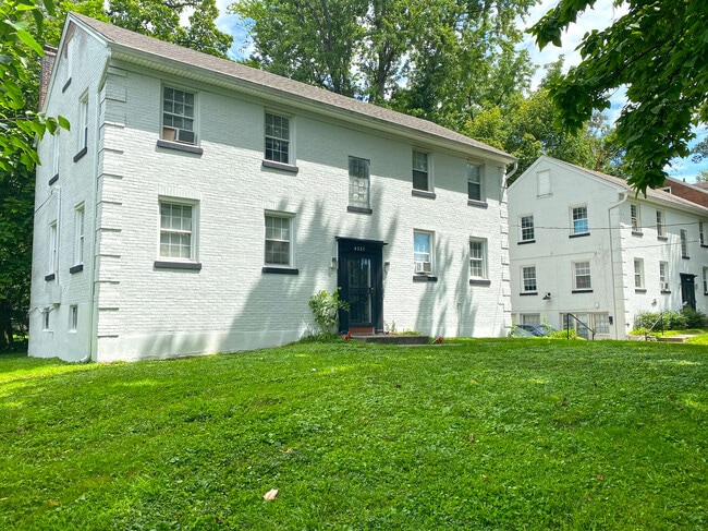
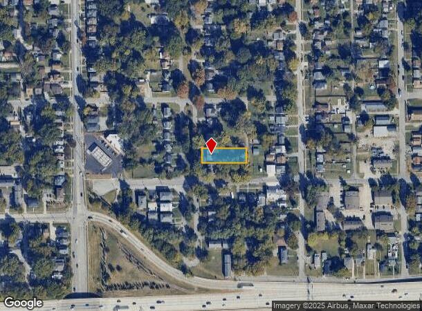
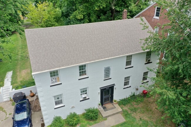
This Property Is For Sale
NEARBY LISTINGS FOR SALE OR LEASE
Property Detail
4329 S 2Nd St
055K00020000
Wilder Park
Apartment
0.2981 AC+/- ES S.2ND ST, 60 NORTH OF FLORENCE AVE, 65 X 200
X
Jefferson
18043C0200E
Kentucky
2025
0.30 AC
2025
Wilder Park
004100
Louisville
2,300 SF
Louisville/Jefferson County, KY-IN
DEMOGRAPHICS near 4329 S 2Nd St
1 Mile
3 Mile
5 Mile
2024 Total Population
12,256
99,803
255,746
2029 Population
12,158
98,708
253,962
Pop Growth 2024-2029
(0.80%)
(1.10%)
(0.70%)
Average Age
38
38
39
2024 Total Households
5,298
42,321
109,978
HH Growth 2024-2029
(0.96%)
(1.13%)
(0.68%)
Median Household Inc
$39,530
$41,797
$43,607
Avg Household Size
2.20
2.20
2.20
2024 Avg HH Vehicles
2.00
1.00
1.00
Median Home Value
$105,257
$150,243
$166,798
Median Year Built
1948
1950
1955
Nearby Places
Map Layers
Map Styles
 Street
 Aerial
- Restaurants
- Banks
- Shops
- Fitness
- Groceries
PUBLIC TRANSPORTATION
AIRPORT
Louisville Muhammad Ali International
DRIVE
WALK
Distance
Louisville Muhammad Ali International
7 min
2.6 mi
Freight Ports
Port of Toledo
DRIVE
WALK
Distance
Port of Toledo
361 min
310.4 mi
Nearby Properties
Address
Land Use
TOTAL SIZE
Lot Size
Zoning
Address
Land Use
TOTAL SIZE
Lot Size
Zoning
42,228 SF
144.63 AC
R5-RESIDEN
Address
Land Use
TOTAL SIZE
Lot Size
Zoning
Address
Land Use
TOTAL SIZE
Lot Size
Zoning
377,041 SF
469.53 AC
Address
Land Use
TOTAL SIZE
Lot Size
Zoning
85,882 SF
80.13 AC
R1-RESIDEN
Address
Land Use
TOTAL SIZE
Lot Size
Zoning
17,916 SF
21.76 AC
EZ1-ENTERP
Address
Land Use
TOTAL SIZE
Lot Size
Zoning
1,584 SF
4.71 AC
R7-RESIDEN
Address
Land Use
TOTAL SIZE
Lot Size
Zoning
260,488 SF
8.07 AC
EZ1-ENTERP
Address
Land Use
TOTAL SIZE
Lot Size
Zoning
Address
Land Use
TOTAL SIZE
Lot Size
Zoning
549,563 SF
26.13 AC
OTF-OFFICE
Address
Land Use
TOTAL SIZE
Lot Size
Zoning
228,447 SF
7.70 AC
M2-INDUSTR
Address
Land Use
TOTAL SIZE
Lot Size
Zoning
58,935 SF
1.92 AC
TNZD-TRADI
Address
Land Use
TOTAL SIZE
Lot Size
Zoning
398,435 SF
9.93 AC
Address
Land Use
TOTAL SIZE
Lot Size
Zoning
6.75 AC
M2-INDUSTR
Address
Land Use
TOTAL SIZE
Lot Size
Zoning
19.50 AC
Address
Land Use
TOTAL SIZE
Lot Size
Zoning
636,716 SF
33.71 AC
Address
Land Use
TOTAL SIZE
Lot Size
Zoning
273,585 SF
42.27 AC
Address
Land Use
TOTAL SIZE
Lot Size
Zoning
142,874 SF
21.93 AC
R5-RESIDEN
Address
Land Use
TOTAL SIZE
Lot Size
Zoning
139,830 SF
Address
Land Use
TOTAL SIZE
Lot Size
Zoning
217,082 SF
26.08 AC
C1-COMMERC
Address
Land Use
TOTAL SIZE
Lot Size
Zoning
16.31 AC
OR1-OFFICE
Address
Land Use
TOTAL SIZE
Lot Size
Zoning
31.15 AC
EZ1-ENTERP
Address
Land Use
TOTAL SIZE
Lot Size
Zoning
17,444 SF
1.47 AC
C2-COMMERC
Address
Land Use
TOTAL SIZE
Lot Size
Zoning
1.61 AC
EZ1-ENTERP
Address
Land Use
TOTAL SIZE
Lot Size
Zoning
2.62 AC
OR2-OFFICE
Address
Land Use
TOTAL SIZE
Lot Size
Zoning
5,560 SF
Address
Land Use
TOTAL SIZE
Lot Size
Zoning
18,770 SF
EZ1-ENTERP
Address
Land Use
TOTAL SIZE
Lot Size
Zoning
9,323 SF
31.90 AC
EZ1-ENTERP
Address
Land Use
TOTAL SIZE
Lot Size
Zoning
16.11 AC
C1-COMMERC
Address
Land Use
TOTAL SIZE
Lot Size
Zoning
39,205 SF
15.50 AC
EZ1-ENTERP
Address
Land Use
TOTAL SIZE
Lot Size
Zoning
5.80 AC
EZ1-ENTERP
The World's #1 Commercial Real Estate Marketplace
Connect with us
© 2026 CoStar Group
The information above has been obtained from sources believed reliable. While we do not doubt its accuracy we have not verified it and make no guarantee, warranty or representation about it. It is your responsibility to independently confirm its accuracy and completeness. Any projections, opinions, assumptions, or estimates used are for example only and do not represent the current or future performance of the property. The value of this transaction to you depends on tax and other factors which should be evaluated by your tax, financial, and legal advisors. You and your advisors should conduct a careful, independent investigation of the property to determine to your satisfaction the suitability of the property for your needs.