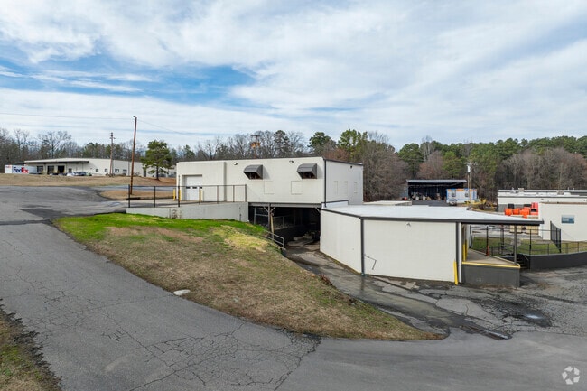
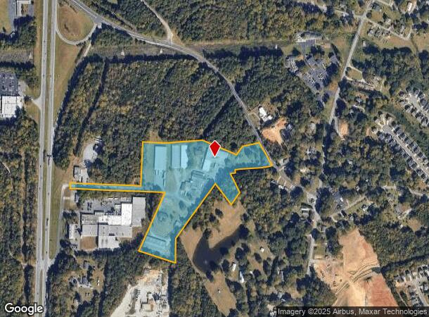
Property Record
400 Interchange Dr, Dallas, NC 28034

NEARBY LISTINGS FOR SALE OR LEASE
Property Detail
400 Interchange Dr
Charlotte-Concord-Gastonia, NC-SC
13 105 062 00 000
308196
Gaston
Industrialgeneral
North Carolina
2025
15.26 AC
2025
Gaston County
030901
Charlotte
12,000 SF
DEMOGRAPHICS near 400 Interchange Dr
1 Mile
3 Mile
5 Mile
2024 Total Population
2,865
31,056
78,398
2029 Population
3,024
33,191
83,655
Pop Growth 2024-2029
+ 5.55%
+ 6.87%
+ 6.71%
Average Age
38
38
39
2024 Total Households
1,200
11,998
31,053
HH Growth 2024-2029
+ 5.75%
+ 7.07%
+ 6.86%
Median Household Inc
$36,358
$41,651
$44,563
Avg Household Size
2.30
2.40
2.40
2024 Avg HH Vehicles
2.00
2.00
2.00
Median Home Value
$190,277
$165,148
$172,953
Median Year Built
1972
1972
1972
Nearby Places
Map Layers
Map Styles
 Street
 Aerial
- Restaurants
- Banks
- Shops
- Fitness
- Groceries
PUBLIC TRANSPORTATION
COMMUTER RAIL
DRIVE
WALK
Distance
9 min
4.1 mi
AIRPORT
Charlotte/Douglas International
DRIVE
WALK
Distance
Charlotte/Douglas International
34 min
19.0 mi
Concord-Padgett Regional
DRIVE
WALK
Distance
Concord-Padgett Regional
48 min
35.3 mi
Nearby Properties
Address
Land Use
TOTAL SIZE
Lot Size
Zoning
Address
Land Use
TOTAL SIZE
Lot Size
Zoning
56,000 SF
23.22 AC
GOV01
Address
Land Use
TOTAL SIZE
Lot Size
Zoning
11,696 SF
159.68 AC
Address
Land Use
TOTAL SIZE
Lot Size
Zoning
159,263 SF
9.83 AC
GOV01
Address
Land Use
TOTAL SIZE
Lot Size
Zoning
17.37 AC
Address
Land Use
TOTAL SIZE
Lot Size
Zoning
312,465 SF
35.23 AC
Address
Land Use
TOTAL SIZE
Lot Size
Zoning
192,315 SF
44.12 AC
INDS1
Address
Land Use
TOTAL SIZE
Lot Size
Zoning
103,890 SF
8.81 AC
OFF04
Address
Land Use
TOTAL SIZE
Lot Size
Zoning
2,688 SF
22.48 AC
OFF01
Address
Land Use
TOTAL SIZE
Lot Size
Zoning
1,680 SF
19.08 AC
OFF01
Address
Land Use
TOTAL SIZE
Lot Size
Zoning
539,988 SF
36.32 AC
STOR6
Address
Land Use
TOTAL SIZE
Lot Size
Zoning
Address
Land Use
TOTAL SIZE
Lot Size
Zoning
123,948 SF
6.94 AC
GOV05
Address
Land Use
TOTAL SIZE
Lot Size
Zoning
0.79 AC
RET01
Address
Land Use
TOTAL SIZE
Lot Size
Zoning
411,076 SF
67.01 AC
INDS2
Address
Land Use
TOTAL SIZE
Lot Size
Zoning
176,657 SF
16.19 AC
Address
Land Use
TOTAL SIZE
Lot Size
Zoning
154,681 SF
63.07 AC
INDS1
Address
Land Use
TOTAL SIZE
Lot Size
Zoning
1,760 SF
3.51 AC
Address
Land Use
TOTAL SIZE
Lot Size
Zoning
163,100 SF
41.60 AC
INDS1
Address
Land Use
TOTAL SIZE
Lot Size
Zoning
57,880 SF
5.99 AC
GOV05
Address
Land Use
TOTAL SIZE
Lot Size
Zoning
16,776 SF
49.87 AC
PUB01
Address
Land Use
TOTAL SIZE
Lot Size
Zoning
50,661 SF
2.32 AC
R1
Address
Land Use
TOTAL SIZE
Lot Size
Zoning
109,085 SF
1.69 AC
BANK1
Address
Land Use
TOTAL SIZE
Lot Size
Zoning
148,300 SF
12.59 AC
INDS2
Address
Land Use
TOTAL SIZE
Lot Size
Zoning
1,914 SF
15.78 AC
MRKT1
Address
Land Use
TOTAL SIZE
Lot Size
Zoning
12.25 AC
Address
Land Use
TOTAL SIZE
Lot Size
Zoning
33,134 SF
6.80 AC
Address
Land Use
TOTAL SIZE
Lot Size
Zoning
13,017 SF
10.75 AC
REST1
Address
Land Use
TOTAL SIZE
Lot Size
Zoning
46,807 SF
4.36 AC
Address
Land Use
TOTAL SIZE
Lot Size
Zoning
3,328 SF
10.16 AC
APT02
Address
Land Use
TOTAL SIZE
Lot Size
Zoning
43,629 SF
4.55 AC
CHUR1
The World's #1 Commercial Real Estate Marketplace
Connect with us
© 2026 CoStar Group
The information above has been obtained from sources believed reliable. While we do not doubt its accuracy we have not verified it and make no guarantee, warranty or representation about it. It is your responsibility to independently confirm its accuracy and completeness. Any projections, opinions, assumptions, or estimates used are for example only and do not represent the current or future performance of the property. The value of this transaction to you depends on tax and other factors which should be evaluated by your tax, financial, and legal advisors. You and your advisors should conduct a careful, independent investigation of the property to determine to your satisfaction the suitability of the property for your needs.