Property Record
433 Route 33 E, East Windsor, NJ 08520
NEARBY LISTINGS FOR SALE OR LEASE
Property Detail
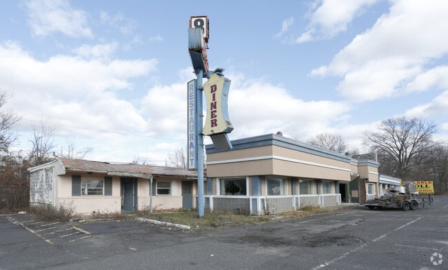
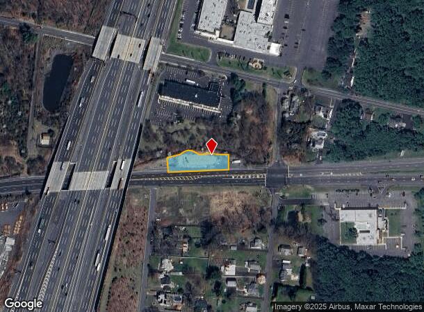
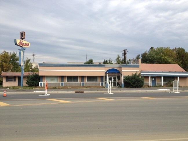
433 Route 33 E
01-00018-0000-00002
MOMS PEPPERMILL
Restaurantbuilding
Mercer
X
New Jersey
34021C0169F
2
2024
0.35 AC
2025
Trenton
004409
Northern New Jersey
4,638 SF
Trenton, NJ
DEMOGRAPHICS near 433 Route 33 E
1 Mile
3 Mile
5 Mile
2024 Total Population
6,868
43,949
75,124
2029 Population
6,812
43,699
74,299
Pop Growth 2024-2029
(0.82%)
(0.57%)
(1.10%)
Average Age
39
41
45
2024 Total Households
2,477
15,604
29,546
HH Growth 2024-2029
(0.97%)
(0.88%)
(1.55%)
Median Household Inc
$90,897
$118,608
$107,118
Avg Household Size
2.70
2.70
2.50
2024 Avg HH Vehicles
2.00
2.00
2.00
Median Home Value
$250,628
$411,247
$392,616
Median Year Built
1971
1982
1983
Nearby Places
- Restaurants
- Banks
- Shops
- Fitness
- Groceries
PUBLIC TRANSPORTATION
COMMUTER RAIL
Princeton Junction (Northeast Corridor Line - NJ Transit Commuter Rail (NJ Transit), Princeton Branch - NJ Transit Commuter Rail (NJ Transit))
DRIVE
WALK
Distance
Princeton Junction (Northeast Corridor Line - NJ Transit Commuter Rail (NJ Transit), Princeton Branch - NJ Transit Commuter Rail (NJ Transit))
16 min
8.1 mi
AIRPORT
Trenton Mercer
DRIVE
WALK
Distance
Trenton Mercer
35 min
21.4 mi
Newark Liberty International
DRIVE
WALK
Distance
Newark Liberty International
54 min
41.4 mi
Freight Ports
New York Container Terminal
DRIVE
WALK
Distance
New York Container Terminal
46 min
36.5 mi
SALE & LEASE HISTORY
LISTING DATE
SALE/LEASE

Sep 24, 2016
For Sale
Aug 23, 2017
For Sale
Nearby Properties
Address
Land Use
TOTAL SIZE
Lot Size
Zoning
Address
Land Use
TOTAL SIZE
Lot Size
Zoning
203.85 AC
I/LI
Address
Land Use
TOTAL SIZE
Lot Size
Zoning
57.09 AC
R-1
Address
Land Use
TOTAL SIZE
Lot Size
Zoning
115.37 AC
I/LI
Address
Land Use
TOTAL SIZE
Lot Size
Zoning
51.01 AC
RO
Address
Land Use
TOTAL SIZE
Lot Size
Zoning
47.51 AC
I/LI
Address
Land Use
TOTAL SIZE
Lot Size
Zoning
318,155 SF
36.28 AC
RO
Address
Land Use
TOTAL SIZE
Lot Size
Zoning
83.35 AC
I/LA
Address
Land Use
TOTAL SIZE
Lot Size
Zoning
2,338 SF
58.26 AC
I/LI
Address
Land Use
TOTAL SIZE
Lot Size
Zoning
376,379 SF
81.40 AC
PRC
Address
Land Use
TOTAL SIZE
Lot Size
Zoning
606,000 SF
51.49 AC
PUD
Address
Land Use
TOTAL SIZE
Lot Size
Zoning
567,798 SF
134.06 AC
RO
Address
Land Use
TOTAL SIZE
Lot Size
Zoning
12.30 AC
R-1
Address
Land Use
TOTAL SIZE
Lot Size
Zoning
69.94 AC
ILIS
Address
Land Use
TOTAL SIZE
Lot Size
Zoning
27.57 AC
PUD
Address
Land Use
TOTAL SIZE
Lot Size
Zoning
46.04 AC
I/LI
Address
Land Use
TOTAL SIZE
Lot Size
Zoning
186,785 SF
29.83 AC
HC
Address
Land Use
TOTAL SIZE
Lot Size
Zoning
243,700 SF
34.78 AC
HC
Address
Land Use
TOTAL SIZE
Lot Size
Zoning
23.60 AC
R1
Address
Land Use
TOTAL SIZE
Lot Size
Zoning
53.56 AC
I/LI
Address
Land Use
TOTAL SIZE
Lot Size
Zoning
15 AC
PUD
Address
Land Use
TOTAL SIZE
Lot Size
Zoning
281,154 SF
39.34 AC
RO
Address
Land Use
TOTAL SIZE
Lot Size
Zoning
35.33 AC
LI
Address
Land Use
TOTAL SIZE
Lot Size
Zoning
22.13 AC
PUD
Address
Land Use
TOTAL SIZE
Lot Size
Zoning
153,230 SF
12.30 AC
HC
Address
Land Use
TOTAL SIZE
Lot Size
Zoning
107,069 SF
16.02 AC
HC
Address
Land Use
TOTAL SIZE
Lot Size
Zoning
8.93 AC
PUD
Address
Land Use
TOTAL SIZE
Lot Size
Zoning
22.47 AC
RO
Address
Land Use
TOTAL SIZE
Lot Size
Zoning
21.81 AC
RO
Address
Land Use
TOTAL SIZE
Lot Size
Zoning
25.53 AC
I/LI
Address
Land Use
TOTAL SIZE
Lot Size
Zoning
22.35 AC
A100
The World's #1 Commercial Real Estate Marketplace
Connect with us
© 2025 CoStar Group
The information above has been obtained from sources believed reliable. While we do not doubt its accuracy we have not verified it and make no guarantee, warranty or representation about it. It is your responsibility to independently confirm its accuracy and completeness. Any projections, opinions, assumptions, or estimates used are for example only and do not represent the current or future performance of the property. The value of this transaction to you depends on tax and other factors which should be evaluated by your tax, financial, and legal advisors. You and your advisors should conduct a careful, independent investigation of the property to determine to your satisfaction the suitability of the property for your needs.