Property Record
433 Oberting Rd, Greendale, IN 47025
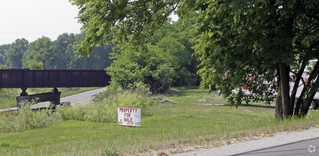

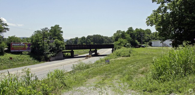
Property Detail
433 Oberting Rd
Cincinnati, OH-KY-IN
05-15 PT 36-6-1 .999A
15-06-36-102-013.000-016
DEARBORN
Agriculturalland
Indiana
AE The base floodplain where base flood elevations are provided. AE Zones are now used on new format FIRMs instead of A1-A30 Zones.
1 AC
2025
Dearborn County
2025
Cincinnati/Dayton
080400
NEARBY LISTINGS FOR SALE OR LEASE
DEMOGRAPHICS near 433 Oberting Rd
1 mile
3 mile
5 mile
2025 Total Population
809
10,416
26,845
2030 Population
816
10,543
27,290
Pop Growth 2025-2030
+ 0.87%
+ 1.22%
+ 1.66%
Average Age
43
42
42
2025 Total Households
308
3,940
10,315
HH Growth 2025-2030
+ 0.97%
+ 1.19%
+ 1.68%
Median Household Inc
$92,954
$95,922
$86,389
Avg Household Size
2.50
2.60
2.50
2025 Avg HH Vehicles
2.00
2.00
2.00
Median Home Value
$314,674
$256,567
$249,772
Median Year Built
1990
1990
1986
Nearby Places
Map Layers
Map Styles
 Street
 Aerial
Layers
 Traffic
 Biking
Places
Listings with unknown addresses are not visible on the map
- Restaurants
- Banks
- Shops
- Fitness
- Groceries
PUBLIC TRANSPORTATION
AIRPORT
Cincinnati/Northern Kentucky International
Drive
Walk
Distance
Cincinnati/Northern Kentucky International
31 min
18.6 mi
Freight Ports
Port of Toledo
Drive
Walk
Distance
Port of Toledo
254 min
216.8 mi
Nearby Properties
Address
Land Use
TOTAL SIZE
Lot Size
Zoning
Address
Land Use
TOTAL SIZE
Lot Size
Zoning
2.10 AC
G
Address
Land Use
TOTAL SIZE
Lot Size
Zoning
24,487 SF
9.29 AC
Address
Land Use
TOTAL SIZE
Lot Size
Zoning
3.30 AC
Address
Land Use
TOTAL SIZE
Lot Size
Zoning
43,895 SF
59.12 AC
Address
Land Use
TOTAL SIZE
Lot Size
Zoning
35,018 SF
4 AC
Address
Land Use
TOTAL SIZE
Lot Size
Zoning
32,169 SF
5.49 AC
Address
Land Use
TOTAL SIZE
Lot Size
Zoning
69,075 SF
3.10 AC
Address
Land Use
TOTAL SIZE
Lot Size
Zoning
40,872 SF
1.31 AC
Address
Land Use
TOTAL SIZE
Lot Size
Zoning
800 SF
501.94 AC
A
Address
Land Use
TOTAL SIZE
Lot Size
Zoning
200 SF
49.08 AC
Address
Land Use
TOTAL SIZE
Lot Size
Zoning
37,296 SF
2.02 AC
Address
Land Use
TOTAL SIZE
Lot Size
Zoning
5,166 SF
8.01 AC
Address
Land Use
TOTAL SIZE
Lot Size
Zoning
20,544 SF
2.43 AC
Address
Land Use
TOTAL SIZE
Lot Size
Zoning
10,415 SF
1.95 AC
Address
Land Use
TOTAL SIZE
Lot Size
Zoning
35,004 SF
1.25 AC
Address
Land Use
TOTAL SIZE
Lot Size
Zoning
15,640 SF
4.71 AC
Address
Land Use
TOTAL SIZE
Lot Size
Zoning
14,684 SF
1.37 AC
Address
Land Use
TOTAL SIZE
Lot Size
Zoning
6,476 SF
2.60 AC
Address
Land Use
TOTAL SIZE
Lot Size
Zoning
47,936 SF
3.26 AC
Address
Land Use
TOTAL SIZE
Lot Size
Zoning
10,500 SF
5.39 AC
Address
Land Use
TOTAL SIZE
Lot Size
Zoning
10,000 SF
4.67 AC
Address
Land Use
TOTAL SIZE
Lot Size
Zoning
17,952 SF
15.08 AC
Address
Land Use
TOTAL SIZE
Lot Size
Zoning
17,460 SF
2.70 AC
Address
Land Use
TOTAL SIZE
Lot Size
Zoning
282.17 AC
H
Address
Land Use
TOTAL SIZE
Lot Size
Zoning
39,220 SF
3.45 AC
Address
Land Use
TOTAL SIZE
Lot Size
Zoning
15,000 SF
2.66 AC
Address
Land Use
TOTAL SIZE
Lot Size
Zoning
5,845 SF
2 AC
Address
Land Use
TOTAL SIZE
Lot Size
Zoning
6,541 SF
1.50 AC
Address
Land Use
TOTAL SIZE
Lot Size
Zoning
7,734 SF
1.18 AC
Address
Land Use
TOTAL SIZE
Lot Size
Zoning
5,596 SF
1.60 AC
The World's #1 Commercial Real Estate Marketplace
Connect with us
© 2026 CoStar Group
The information above has been obtained from sources believed reliable. While we do not doubt its accuracy we have not verified it and make no guarantee, warranty or representation about it. It is your responsibility to independently confirm its accuracy and completeness. Any projections, opinions, assumptions, or estimates used are for example only and do not represent the current or future performance of the property. The value of this transaction to you depends on tax and other factors which should be evaluated by your tax, financial, and legal advisors. You and your advisors should conduct a careful, independent investigation of the property to determine to your satisfaction the suitability of the property for your needs.