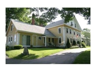
Property Record
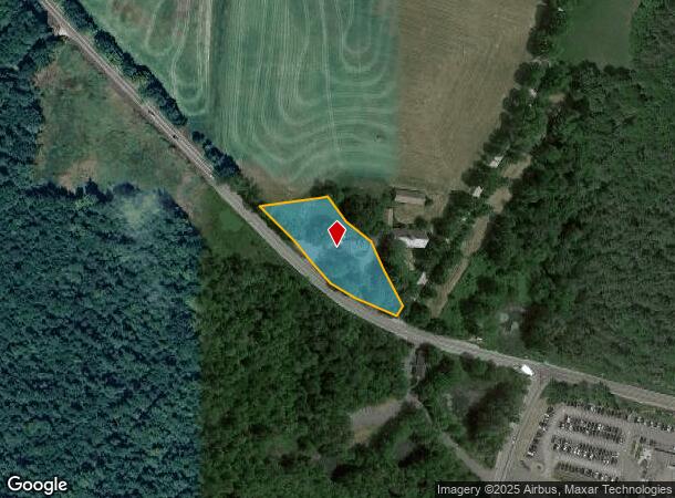
433 Turnpike Rd, Jaffrey, NH 03452
NEARBY LISTINGS FOR SALE OR LEASE
-
-
View all Jaffrey listings for sale on LoopNet.com
Property Detail
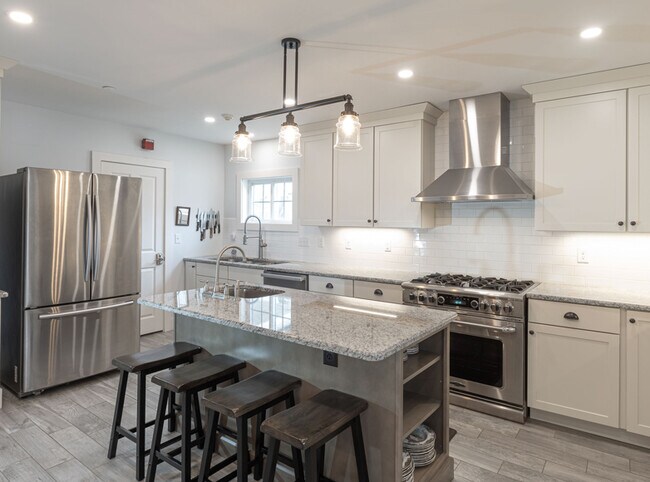
433 Turnpike Rd
Resorthotel
Cheshire
X
New Hampshire
33011C0415D
1.03 AC
2024
Manchester/New Hampshire South Area
2024
Other Market Areas
970500
Keene, NH
4,892 SF
JAFF-000256-000006
DEMOGRAPHICS near 433 Turnpike Rd
1 Mile
3 Mile
5 Mile
2024 Total Population
334
6,366
12,325
2029 Population
354
6,692
12,937
Pop Growth 2024-2029
+ 5.99%
+ 5.12%
+ 4.97%
Average Age
43
41
41
2024 Total Households
140
2,382
4,606
HH Growth 2024-2029
+ 5.71%
+ 5.12%
+ 4.99%
Median Household Inc
$70,833
$73,836
$85,336
Avg Household Size
2.30
2.40
2.40
2024 Avg HH Vehicles
2.00
2.00
2.00
Median Home Value
$213,207
$231,974
$261,261
Median Year Built
1958
1972
1976
Nearby Places
Map Layers
Map Styles
 Street
 Aerial
- Restaurants
- Banks
- Shops
- Fitness
- Groceries
PUBLIC TRANSPORTATION
AIRPORT
Manchester Boston Regional
DRIVE
WALK
Distance
Manchester Boston Regional
74 min
40.5 mi
Freight Ports
Port of Boston
DRIVE
WALK
Distance
Port of Boston
111 min
64.8 mi
SALE & LEASE HISTORY
LISTING DATE
SALE/LEASE

Apr 07, 2021
For Sale
Nearby Properties
Address
Land Use
TOTAL SIZE
Lot Size
Zoning
Address
Land Use
TOTAL SIZE
Lot Size
Zoning
2,276 SF
146 AC
IND
Address
Land Use
TOTAL SIZE
Lot Size
Zoning
67,754 SF
28 AC
RB2
Address
Land Use
TOTAL SIZE
Lot Size
Zoning
4.36 AC
RA1
Address
Land Use
TOTAL SIZE
Lot Size
Zoning
56,684 SF
3.51 AC
RA2
Address
Land Use
TOTAL SIZE
Lot Size
Zoning
39,133 SF
10.88 AC
GB
Address
Land Use
TOTAL SIZE
Lot Size
Zoning
30,677 SF
5.14 AC
IND
Address
Land Use
TOTAL SIZE
Lot Size
Zoning
44.39 AC
Address
Land Use
TOTAL SIZE
Lot Size
Zoning
80,781 SF
8.88 AC
IND
Address
Land Use
TOTAL SIZE
Lot Size
Zoning
32,597 SF
5.17 AC
GB
Address
Land Use
TOTAL SIZE
Lot Size
Zoning
17,360 SF
4.01 AC
RA2
Address
Land Use
TOTAL SIZE
Lot Size
Zoning
4.51 AC
COM
Address
Land Use
TOTAL SIZE
Lot Size
Zoning
4.73 AC
I
Address
Land Use
TOTAL SIZE
Lot Size
Zoning
16,096 SF
2.89 AC
GB
Address
Land Use
TOTAL SIZE
Lot Size
Zoning
28,141 SF
72.70 AC
IND
Address
Land Use
TOTAL SIZE
Lot Size
Zoning
5,888 SF
8.35 AC
RA2
Address
Land Use
TOTAL SIZE
Lot Size
Zoning
24.30 AC
COM
Address
Land Use
TOTAL SIZE
Lot Size
Zoning
9,628 SF
3.70 AC
R2
Address
Land Use
TOTAL SIZE
Lot Size
Zoning
13,842 SF
19.99 AC
R1
Address
Land Use
TOTAL SIZE
Lot Size
Zoning
131.20 AC
RESIDE
Address
Land Use
TOTAL SIZE
Lot Size
Zoning
7,780 SF
0.77 AC
GB
Address
Land Use
TOTAL SIZE
Lot Size
Zoning
3,200 SF
49 AC
R1
Address
Land Use
TOTAL SIZE
Lot Size
Zoning
6,736 SF
7 AC
RA2
Address
Land Use
TOTAL SIZE
Lot Size
Zoning
10,856 SF
1.58 AC
GB
Address
Land Use
TOTAL SIZE
Lot Size
Zoning
25,600 SF
9.38 AC
IND
Address
Land Use
TOTAL SIZE
Lot Size
Zoning
47,053 SF
3.59 AC
IND
Address
Land Use
TOTAL SIZE
Lot Size
Zoning
8,555 SF
0.63 AC
GB
Address
Land Use
TOTAL SIZE
Lot Size
Zoning
5,950 SF
4.56 AC
IND
Address
Land Use
TOTAL SIZE
Lot Size
Zoning
40,120 SF
1.32 AC
GB
Address
Land Use
TOTAL SIZE
Lot Size
Zoning
30 AC
RESIDE
Address
Land Use
TOTAL SIZE
Lot Size
Zoning
47,347 SF
3.59 AC
IND
The World's #1 Commercial Real Estate Marketplace
Connect with us
© 2026 CoStar Group
The information above has been obtained from sources believed reliable. While we do not doubt its accuracy we have not verified it and make no guarantee, warranty or representation about it. It is your responsibility to independently confirm its accuracy and completeness. Any projections, opinions, assumptions, or estimates used are for example only and do not represent the current or future performance of the property. The value of this transaction to you depends on tax and other factors which should be evaluated by your tax, financial, and legal advisors. You and your advisors should conduct a careful, independent investigation of the property to determine to your satisfaction the suitability of the property for your needs.