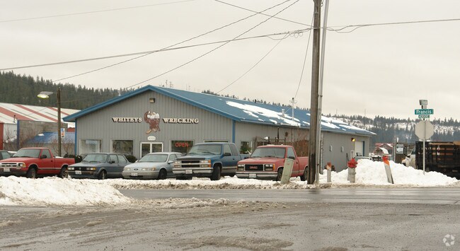
Property Record
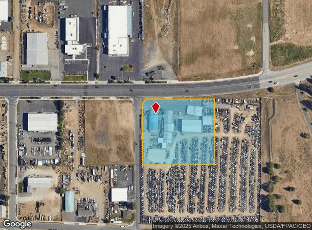
4330 E Francis Ave, Spokane, WA 99217

NEARBY LISTINGS FOR SALE OR LEASE
Property Detail
4330 E Francis Ave
Spokane-Spokane Valley, WA
Hillyard
36341.3408
HILLYARD ACRE TRACTS LTS 8, 9 & 10 BLK 6 TOG W/ N 1/2 OF VAC ALLEY LYG S OF & ADJ TO SD LTS (VAC ORD# C39807) & EXC RD (PER SWD AFN 5999322)
Storebuilding
Spokane
X
Washington
53063C0555D
8,10
2025
2.87 AC
2025
SE North Metro
014400
Spokane
26,756 SF
DEMOGRAPHICS near 4330 E Francis Ave
1 Mile
3 Mile
5 Mile
2024 Total Population
2,293
63,706
180,176
2029 Population
2,450
67,698
191,371
Pop Growth 2024-2029
+ 6.85%
+ 6.27%
+ 6.21%
Average Age
40
39
39
2024 Total Households
872
25,886
71,116
HH Growth 2024-2029
+ 7.00%
+ 6.43%
+ 6.42%
Median Household Inc
$50,819
$51,664
$56,833
Avg Household Size
2.50
2.40
2.40
2024 Avg HH Vehicles
2.00
2.00
2.00
Median Home Value
$270,212
$249,109
$281,893
Median Year Built
1964
1972
1965
Nearby Places
Map Layers
Map Styles
 Street
 Aerial
- Restaurants
- Banks
- Shops
- Fitness
- Groceries
PUBLIC TRANSPORTATION
COMMUTER RAIL
DRIVE
WALK
Distance
17 min
6.7 mi
AIRPORT
Spokane International
DRIVE
WALK
Distance
Spokane International
25 min
14.0 mi
Nearby Properties
Address
Land Use
TOTAL SIZE
Lot Size
Zoning
Address
Land Use
TOTAL SIZE
Lot Size
Zoning
531,295 SF
17.11 AC
CC2
Address
Land Use
TOTAL SIZE
Lot Size
Zoning
427,054 SF
16.60 AC
LI
Address
Land Use
TOTAL SIZE
Lot Size
Zoning
386,885 SF
22.81 AC
RSF
Address
Land Use
TOTAL SIZE
Lot Size
Zoning
310,606 SF
27.56 AC
RMF
Address
Land Use
TOTAL SIZE
Lot Size
Zoning
180,822 SF
16.11 AC
CC1
Address
Land Use
TOTAL SIZE
Lot Size
Zoning
456,984 SF
26.06 AC
O
Address
Land Use
TOTAL SIZE
Lot Size
Zoning
696,382 SF
37.43 AC
LI
Address
Land Use
TOTAL SIZE
Lot Size
Zoning
1,555,116 SF
23.12 AC
GC
Address
Land Use
TOTAL SIZE
Lot Size
Zoning
56,600 SF
4.98 AC
GC
Address
Land Use
TOTAL SIZE
Lot Size
Zoning
158,348 SF
6.60 AC
RMF
Address
Land Use
TOTAL SIZE
Lot Size
Zoning
134,806 SF
7.79 AC
RMF
Address
Land Use
TOTAL SIZE
Lot Size
Zoning
136,780 SF
8.75 AC
RMF
Address
Land Use
TOTAL SIZE
Lot Size
Zoning
101,372 SF
5.48 AC
RMF
Address
Land Use
TOTAL SIZE
Lot Size
Zoning
131,469 SF
7.24 AC
RMF
Address
Land Use
TOTAL SIZE
Lot Size
Zoning
153,780 SF
10.31 AC
RMF
Address
Land Use
TOTAL SIZE
Lot Size
Zoning
95,030 SF
3.51 AC
CC1
Address
Land Use
TOTAL SIZE
Lot Size
Zoning
67,094 SF
9.33 AC
RSF
Address
Land Use
TOTAL SIZE
Lot Size
Zoning
160,810 SF
25.18 AC
RMF
Address
Land Use
TOTAL SIZE
Lot Size
Zoning
96,424 SF
9.04 AC
I-1
Address
Land Use
TOTAL SIZE
Lot Size
Zoning
35,343 SF
5.31 AC
GC
Address
Land Use
TOTAL SIZE
Lot Size
Zoning
125,588 SF
12.84 AC
RMF
Address
Land Use
TOTAL SIZE
Lot Size
Zoning
179,208 SF
13.94 AC
RMF
Address
Land Use
TOTAL SIZE
Lot Size
Zoning
183,704 SF
12.67 AC
RMF
Address
Land Use
TOTAL SIZE
Lot Size
Zoning
142,448 SF
14.85 AC
RMF
Address
Land Use
TOTAL SIZE
Lot Size
Zoning
134,104 SF
5.89 AC
HDR
Address
Land Use
TOTAL SIZE
Lot Size
Zoning
107,539 SF
7.54 AC
RMF
Address
Land Use
TOTAL SIZE
Lot Size
Zoning
123,142 SF
2.22 AC
RHD
Address
Land Use
TOTAL SIZE
Lot Size
Zoning
103,755 SF
7.64 AC
CC2
Address
Land Use
TOTAL SIZE
Lot Size
Zoning
68,197 SF
5.16 AC
RSF
Address
Land Use
TOTAL SIZE
Lot Size
Zoning
118,818 SF
7.96 AC
HDR
The World's #1 Commercial Real Estate Marketplace
Connect with us
© 2026 CoStar Group
The information above has been obtained from sources believed reliable. While we do not doubt its accuracy we have not verified it and make no guarantee, warranty or representation about it. It is your responsibility to independently confirm its accuracy and completeness. Any projections, opinions, assumptions, or estimates used are for example only and do not represent the current or future performance of the property. The value of this transaction to you depends on tax and other factors which should be evaluated by your tax, financial, and legal advisors. You and your advisors should conduct a careful, independent investigation of the property to determine to your satisfaction the suitability of the property for your needs.