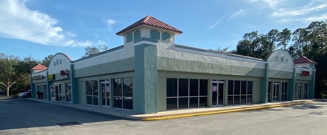
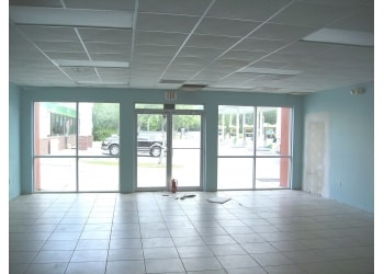
Property Record
4330 Lithia Pinecrest Rd, Valrico, FL 33596
NEARBY LISTINGS FOR SALE OR LEASE
Property Detail
4330 Lithia Pinecrest Rd
Tampa-St. Petersburg-Clearwater, FL
Unplatted
U-17-30-21-ZZZ-000004-36470.0
COMM AT SE COR OF NE 1/4 RUN N 137 FT THN W 1301.33 FT THN N 1379 FT TO POB RUN N 90 DEG W 217.29 FT THN N 32.12 FT THN ALG ARC OF CURVE TO RT CB S 21 DEG 31 MIN 49 SEC W 45.51 FT W/RAD 62 FT THN N 43 DEG 03 MIN 39 SEC E 138.81 FT THN S 47 DEG 03 MIN
Servicestationmarket
Hillsborough
AE
Florida
12057C0415H
36470
2024
1.29 AC
2024
Eastern Outlying
013409
Tampa/St Petersburg
4,010 SF
DEMOGRAPHICS near 4330 Lithia Pinecrest Rd
1 Mile
3 Mile
5 Mile
2024 Total Population
4,055
56,706
123,391
2029 Population
4,391
61,494
134,146
Pop Growth 2024-2029
+ 8.29%
+ 8.44%
+ 8.72%
Average Age
40
39
40
2024 Total Households
1,345
18,688
42,532
HH Growth 2024-2029
+ 8.48%
+ 8.71%
+ 8.95%
Median Household Inc
$111,631
$110,667
$97,054
Avg Household Size
3.00
3.00
2.90
2024 Avg HH Vehicles
2.00
2.00
2.00
Median Home Value
$390,983
$368,182
$347,746
Median Year Built
1996
1998
1995
Nearby Places
Map Layers
Map Styles
 Street
 Aerial
- Restaurants
- Banks
- Shops
- Fitness
- Groceries
PUBLIC TRANSPORTATION
AIRPORT
Tampa International
DRIVE
WALK
Distance
Tampa International
42 min
25.2 mi
St Pete-Clearwater International
DRIVE
WALK
Distance
St Pete-Clearwater International
59 min
35.3 mi
Freight Ports
Port of Tampa Bay
DRIVE
WALK
Distance
Port of Tampa Bay
30 min
16.1 mi
Nearby Properties
Address
Land Use
TOTAL SIZE
Lot Size
Zoning
Address
Land Use
TOTAL SIZE
Lot Size
Zoning
421,873 SF
93.26 AC
PD
Address
Land Use
TOTAL SIZE
Lot Size
Zoning
361,294 SF
10.30 AC
PD
Address
Land Use
TOTAL SIZE
Lot Size
Zoning
288,270 SF
78.75 AC
PD
Address
Land Use
TOTAL SIZE
Lot Size
Zoning
231,811 SF
26.54 AC
PD
Address
Land Use
TOTAL SIZE
Lot Size
Zoning
105,409 SF
18.40 AC
PD
Address
Land Use
TOTAL SIZE
Lot Size
Zoning
182,688 SF
14.69 AC
PD
Address
Land Use
TOTAL SIZE
Lot Size
Zoning
113,134 SF
7.96 AC
PD
Address
Land Use
TOTAL SIZE
Lot Size
Zoning
141,626 SF
8.88 AC
PD
Address
Land Use
TOTAL SIZE
Lot Size
Zoning
870 AC
AR
Address
Land Use
TOTAL SIZE
Lot Size
Zoning
25,210 SF
66.38 AC
AR
Address
Land Use
TOTAL SIZE
Lot Size
Zoning
57,438 SF
12.28 AC
PD
Address
Land Use
TOTAL SIZE
Lot Size
Zoning
124,207 SF
28.64 AC
RSC-6
Address
Land Use
TOTAL SIZE
Lot Size
Zoning
101,727 SF
11.18 AC
PD
Address
Land Use
TOTAL SIZE
Lot Size
Zoning
158,777 SF
15.23 AC
TND
Address
Land Use
TOTAL SIZE
Lot Size
Zoning
96,158 SF
11.98 AC
PD
Address
Land Use
TOTAL SIZE
Lot Size
Zoning
233.81 AC
AR
Address
Land Use
TOTAL SIZE
Lot Size
Zoning
99,450 SF
13.65 AC
PD
Address
Land Use
TOTAL SIZE
Lot Size
Zoning
97,587 SF
24.06 AC
PD
Address
Land Use
TOTAL SIZE
Lot Size
Zoning
110,461 SF
5.72 AC
PD
Address
Land Use
TOTAL SIZE
Lot Size
Zoning
99,384 SF
14.72 AC
PD
Address
Land Use
TOTAL SIZE
Lot Size
Zoning
90,441 SF
20.39 AC
AS-1
Address
Land Use
TOTAL SIZE
Lot Size
Zoning
67,300 SF
10.03 AC
PD
Address
Land Use
TOTAL SIZE
Lot Size
Zoning
71,488 SF
11.55 AC
PD
Address
Land Use
TOTAL SIZE
Lot Size
Zoning
68,422 SF
9.14 AC
PD
Address
Land Use
TOTAL SIZE
Lot Size
Zoning
69,591 SF
38.33 AC
PD
Address
Land Use
TOTAL SIZE
Lot Size
Zoning
104,890 SF
15.03 AC
ASC-1
Address
Land Use
TOTAL SIZE
Lot Size
Zoning
36,254 SF
3.48 AC
PD
Address
Land Use
TOTAL SIZE
Lot Size
Zoning
93,917 SF
30.89 AC
PD
Address
Land Use
TOTAL SIZE
Lot Size
Zoning
90,250 SF
11 AC
PD
Address
Land Use
TOTAL SIZE
Lot Size
Zoning
54,698 SF
8.28 AC
PD
The World's #1 Commercial Real Estate Marketplace
Connect with us
© 2026 CoStar Group
The information above has been obtained from sources believed reliable. While we do not doubt its accuracy we have not verified it and make no guarantee, warranty or representation about it. It is your responsibility to independently confirm its accuracy and completeness. Any projections, opinions, assumptions, or estimates used are for example only and do not represent the current or future performance of the property. The value of this transaction to you depends on tax and other factors which should be evaluated by your tax, financial, and legal advisors. You and your advisors should conduct a careful, independent investigation of the property to determine to your satisfaction the suitability of the property for your needs.