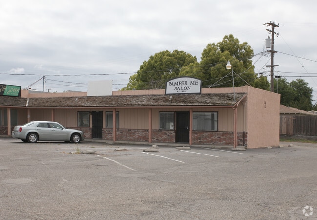
Property Record
4330 Main St, Denair, CA 95316


NEARBY LISTINGS FOR SALE OR LEASE
-
-
View all Denair listings for sale on LoopNet.com
Property Detail
4330 Main St
Modesto, CA
Jd
024-31-32
EQUIPMENT & SUPPLIES DD
Regionalshoppingcenterormallwithanchorstore
Stanislaus
X
California
06099C0600E
46-48
2025
1.51 AC
2025
Hughson/Oakdale/Waterford
003608
Stockton/Modesto
13,990 SF
DEMOGRAPHICS near 4330 Main St
1 Mile
3 Mile
5 Mile
2024 Total Population
5,232
36,184
84,717
2029 Population
5,214
36,249
84,829
Pop Growth 2024-2029
(0.34%)
+ 0.18%
+ 0.13%
Average Age
38
39
37
2024 Total Households
1,702
12,549
28,161
HH Growth 2024-2029
(0.41%)
+ 0.23%
+ 0.18%
Median Household Inc
$107,816
$86,113
$74,969
Avg Household Size
3.00
2.80
2.90
2024 Avg HH Vehicles
2.00
2.00
2.00
Median Home Value
$454,025
$459,694
$415,842
Median Year Built
1978
1978
1982
Nearby Places
Map Layers
Map Styles
 Street
 Aerial
- Restaurants
- Banks
- Shops
- Fitness
- Groceries
PUBLIC TRANSPORTATION
COMMUTER RAIL
DRIVE
WALK
Distance
1 min
6 min
0.3 mi
AIRPORT
Stockton Metro
DRIVE
WALK
Distance
Stockton Metro
55 min
40.1 mi
Freight Ports
Port of Stockton
DRIVE
WALK
Distance
Port of Stockton
63 min
48.5 mi
Nearby Properties
Address
Land Use
TOTAL SIZE
Lot Size
Zoning
Address
Land Use
TOTAL SIZE
Lot Size
Zoning
281,904 SF
17.84 AC
Address
Land Use
TOTAL SIZE
Lot Size
Zoning
144,510 SF
12.04 AC
Address
Land Use
TOTAL SIZE
Lot Size
Zoning
111,617 SF
10.10 AC
Address
Land Use
TOTAL SIZE
Lot Size
Zoning
149,310 SF
8.45 AC
Address
Land Use
TOTAL SIZE
Lot Size
Zoning
103,011 SF
7.90 AC
Address
Land Use
TOTAL SIZE
Lot Size
Zoning
68,015 SF
4.45 AC
CO
Address
Land Use
TOTAL SIZE
Lot Size
Zoning
44,860 SF
2.93 AC
Address
Land Use
TOTAL SIZE
Lot Size
Zoning
120,762 SF
9.39 AC
Address
Land Use
TOTAL SIZE
Lot Size
Zoning
110,184 SF
6.60 AC
Address
Land Use
TOTAL SIZE
Lot Size
Zoning
100,911 SF
14.88 AC
Address
Land Use
TOTAL SIZE
Lot Size
Zoning
49,250 SF
2.77 AC
Address
Land Use
TOTAL SIZE
Lot Size
Zoning
42,096 SF
3.17 AC
Address
Land Use
TOTAL SIZE
Lot Size
Zoning
57,674 SF
4 AC
Address
Land Use
TOTAL SIZE
Lot Size
Zoning
48,612 SF
2.53 AC
Address
Land Use
TOTAL SIZE
Lot Size
Zoning
93,448 SF
4.77 AC
Address
Land Use
TOTAL SIZE
Lot Size
Zoning
177,727 SF
9.14 AC
Address
Land Use
TOTAL SIZE
Lot Size
Zoning
34,156 SF
6.25 AC
Address
Land Use
TOTAL SIZE
Lot Size
Zoning
19,727 SF
2.06 AC
TURCC
Address
Land Use
TOTAL SIZE
Lot Size
Zoning
28,888 SF
2.07 AC
Address
Land Use
TOTAL SIZE
Lot Size
Zoning
21,480 SF
1.53 AC
Address
Land Use
TOTAL SIZE
Lot Size
Zoning
2,525 SF
123.24 AC
Address
Land Use
TOTAL SIZE
Lot Size
Zoning
7,240 SF
101.54 AC
A240
Address
Land Use
TOTAL SIZE
Lot Size
Zoning
4,338 SF
326.36 AC
A240
Address
Land Use
TOTAL SIZE
Lot Size
Zoning
3,682 SF
18.61 AC
Address
Land Use
TOTAL SIZE
Lot Size
Zoning
41,268 SF
2.80 AC
Address
Land Use
TOTAL SIZE
Lot Size
Zoning
17,526 SF
1.62 AC
C2
Address
Land Use
TOTAL SIZE
Lot Size
Zoning
41,026 SF
2.82 AC
Address
Land Use
TOTAL SIZE
Lot Size
Zoning
34,882 SF
1.04 AC
TURPD
Address
Land Use
TOTAL SIZE
Lot Size
Zoning
54,495 SF
4.95 AC
Address
Land Use
TOTAL SIZE
Lot Size
Zoning
25,200 SF
1.91 AC
The World's #1 Commercial Real Estate Marketplace
Connect with us
© 2026 CoStar Group
The information above has been obtained from sources believed reliable. While we do not doubt its accuracy we have not verified it and make no guarantee, warranty or representation about it. It is your responsibility to independently confirm its accuracy and completeness. Any projections, opinions, assumptions, or estimates used are for example only and do not represent the current or future performance of the property. The value of this transaction to you depends on tax and other factors which should be evaluated by your tax, financial, and legal advisors. You and your advisors should conduct a careful, independent investigation of the property to determine to your satisfaction the suitability of the property for your needs.