Property Record
4330 S Eastern Ave, Las Vegas, NV 89119
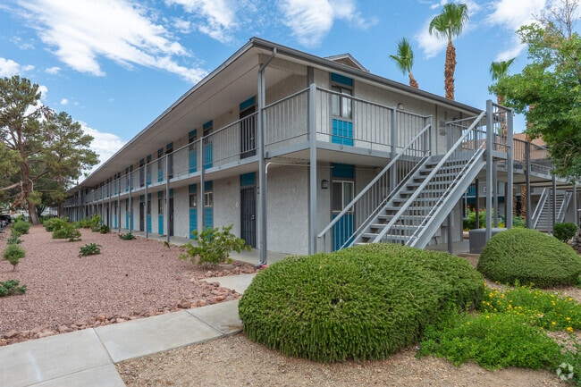

Property Detail
4330 S Eastern Ave
Las Vegas-Henderson-North Las Vegas, NV
GOLDEN LIVING CENTER AMD PLAT BOOK 32 PAGE 10 UNIT 11 BLDG 3 PHASE IV & VAC RD
162-24-210-101
CLARK
Apartment
Nevada
B and X Area of moderate flood hazard, usually the area between the limits of the 100-year and 500-year floods.
11
2026
0.50 AC
2026
Paradise Valley East
001711
Las Vegas
1,374 SF
NEARBY LISTINGS FOR SALE OR LEASE
DEMOGRAPHICS near 4330 S Eastern Ave
1 mile
3 mile
5 mile
2025 Total Population
26,349
167,041
451,646
2030 Population
27,505
174,551
473,527
Pop Growth 2025-2030
+ 4.39%
+ 4.50%
+ 4.84%
Average Age
41
41
40
2025 Total Households
12,102
69,811
182,105
HH Growth 2025-2030
+ 4.41%
+ 4.42%
+ 5.04%
Median Household Inc
$50,784
$53,269
$56,142
Avg Household Size
2.10
2.30
2.40
2025 Avg HH Vehicles
1.00
1.00
1.00
Median Home Value
$354,002
$356,615
$364,804
Median Year Built
1981
1978
1985
Nearby Places
Map Layers
Map Styles
 Street
 Aerial
Layers
 Traffic
 Biking
Places
Listings with unknown addresses are not visible on the map
- Restaurants
- Banks
- Shops
- Fitness
- Groceries
PUBLIC TRANSPORTATION
AIRPORT
Harry Reid International
Drive
Walk
Distance
Harry Reid International
8 min
3.8 mi
Boulder City Municipal
Drive
Walk
Distance
Boulder City Municipal
29 min
21.3 mi
Freight Ports
Port of Long Beach
Drive
Walk
Distance
Port of Long Beach
316 min
280.7 mi
Nearby Properties
Address
Land Use
TOTAL SIZE
Lot Size
Zoning
Address
Land Use
TOTAL SIZE
Lot Size
Zoning
3,693,440 SF
43.59 AC
Address
Land Use
TOTAL SIZE
Lot Size
Zoning
3,391,505 SF
68.52 AC
Address
Land Use
TOTAL SIZE
Lot Size
Zoning
3,391,505 SF
68.55 AC
Address
Land Use
TOTAL SIZE
Lot Size
Zoning
1,172,527 SF
19.67 AC
H1
Address
Land Use
TOTAL SIZE
Lot Size
Zoning
2,828,726 SF
101.88 AC
Address
Land Use
TOTAL SIZE
Lot Size
Zoning
8,805 SF
45.63 AC
Address
Land Use
TOTAL SIZE
Lot Size
Zoning
2,414,853 SF
16.59 AC
H1
Address
Land Use
TOTAL SIZE
Lot Size
Zoning
74,148 SF
18.51 AC
Address
Land Use
TOTAL SIZE
Lot Size
Zoning
763,204 SF
10.47 AC
H1
Address
Land Use
TOTAL SIZE
Lot Size
Zoning
171,303 SF
17.87 AC
H1
Address
Land Use
TOTAL SIZE
Lot Size
Zoning
79.03 AC
PF
Address
Land Use
TOTAL SIZE
Lot Size
Zoning
873,377 SF
28.08 AC
Address
Land Use
TOTAL SIZE
Lot Size
Zoning
524,471 SF
59.01 AC
Address
Land Use
TOTAL SIZE
Lot Size
Zoning
323,696 SF
24.62 AC
H1
Address
Land Use
TOTAL SIZE
Lot Size
Zoning
76.93 AC
PF
Address
Land Use
TOTAL SIZE
Lot Size
Zoning
566,218 SF
12.98 AC
Address
Land Use
TOTAL SIZE
Lot Size
Zoning
126,656 SF
8.18 AC
H1
Address
Land Use
TOTAL SIZE
Lot Size
Zoning
48.58 AC
PF
Address
Land Use
TOTAL SIZE
Lot Size
Zoning
138.07 AC
PF
Address
Land Use
TOTAL SIZE
Lot Size
Zoning
94,198 SF
34.53 AC
H1
Address
Land Use
TOTAL SIZE
Lot Size
Zoning
281,120 SF
21.38 AC
Address
Land Use
TOTAL SIZE
Lot Size
Zoning
1,259,278 SF
15.99 AC
H1
Address
Land Use
TOTAL SIZE
Lot Size
Zoning
56.95 AC
PF
Address
Land Use
TOTAL SIZE
Lot Size
Zoning
345,133 SF
27.01 AC
H1
Address
Land Use
TOTAL SIZE
Lot Size
Zoning
20.21 AC
H1
Address
Land Use
TOTAL SIZE
Lot Size
Zoning
153,122 SF
4.25 AC
Address
Land Use
TOTAL SIZE
Lot Size
Zoning
157,191 SF
5.97 AC
Address
Land Use
TOTAL SIZE
Lot Size
Zoning
71,399 SF
6.78 AC
H1
Address
Land Use
TOTAL SIZE
Lot Size
Zoning
1,422,213 SF
3.91 AC
H1
Address
Land Use
TOTAL SIZE
Lot Size
Zoning
257,182 SF
4 AC
The World's #1 Commercial Real Estate Marketplace
Connect with us
© 2026 CoStar Group
The information above has been obtained from sources believed reliable. While we do not doubt its accuracy we have not verified it and make no guarantee, warranty or representation about it. It is your responsibility to independently confirm its accuracy and completeness. Any projections, opinions, assumptions, or estimates used are for example only and do not represent the current or future performance of the property. The value of this transaction to you depends on tax and other factors which should be evaluated by your tax, financial, and legal advisors. You and your advisors should conduct a careful, independent investigation of the property to determine to your satisfaction the suitability of the property for your needs.