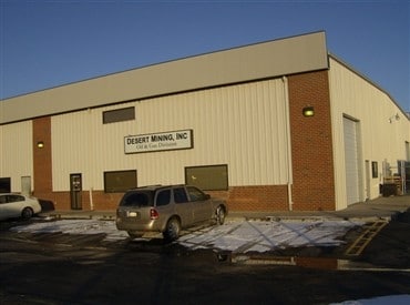
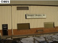
Property Record
4330 State Highway 66, Mead, CO 80504

Property Detail
4330 State Highway 66
Greeley, CO
MEA SB5-1 L1 BLK5 SEKICH BUSINESS PARK
R6790697
WELD
Commercialnec
Colorado
B and X Area of moderate flood hazard, usually the area between the limits of the 100-year and 500-year floods.
1
2024
1.01 AC
2025
Weld County
002105
Denver
14,018 SF
NEARBY LISTINGS FOR SALE OR LEASE
DEMOGRAPHICS near 4330 State Highway 66
1 mile
3 mile
5 mile
2025 Total Population
25
9,295
33,188
2030 Population
28
10,451
36,470
Pop Growth 2025-2030
+ 12.00%
+ 12.44%
+ 9.89%
Average Age
41
40
39
2025 Total Households
9
3,377
11,538
HH Growth 2025-2030
+ 11.11%
+ 12.73%
+ 10.11%
Median Household Inc
$124,999
$106,291
$118,124
Avg Household Size
2.60
2.70
2.90
2025 Avg HH Vehicles
2.00
2.00
2.00
Median Home Value
$750,000
$718,487
$674,448
Median Year Built
2007
2007
2007
Nearby Places
Map Layers
Map Styles
 Street
 Aerial
Transit
 Traffic
 Biking
Places
Listings with unknown addresses are not visible on the map
- Restaurants
- Banks
- Shops
- Fitness
- Groceries
PUBLIC TRANSPORTATION
AIRPORT
Denver International
Drive
Walk
Distance
Denver International
45 min
40.4 mi
Freight Ports
Tulsa Port Of Catoosa
Drive
Walk
Distance
Tulsa Port Of Catoosa
752 min
734.6 mi
Nearby Properties
Address
Land Use
TOTAL SIZE
Lot Size
Zoning
Address
Land Use
TOTAL SIZE
Lot Size
Zoning
129,387 SF
47.65 AC
Address
Land Use
TOTAL SIZE
Lot Size
Zoning
161,333 SF
74.39 AC
Address
Land Use
TOTAL SIZE
Lot Size
Zoning
429,053 SF
19.92 AC
Address
Land Use
TOTAL SIZE
Lot Size
Zoning
196,142 SF
19.13 AC
Address
Land Use
TOTAL SIZE
Lot Size
Zoning
109,676 SF
6.37 AC
Address
Land Use
TOTAL SIZE
Lot Size
Zoning
94,076 SF
6.04 AC
Address
Land Use
TOTAL SIZE
Lot Size
Zoning
125,978 SF
118.07 AC
Address
Land Use
TOTAL SIZE
Lot Size
Zoning
42,765 SF
23.90 AC
Address
Land Use
TOTAL SIZE
Lot Size
Zoning
71,373 SF
65.55 AC
Address
Land Use
TOTAL SIZE
Lot Size
Zoning
4,799 SF
133.29 AC
Address
Land Use
TOTAL SIZE
Lot Size
Zoning
83,752 SF
4.75 AC
Address
Land Use
TOTAL SIZE
Lot Size
Zoning
86,375 SF
6.24 AC
Address
Land Use
TOTAL SIZE
Lot Size
Zoning
56,090 SF
3.31 AC
Address
Land Use
TOTAL SIZE
Lot Size
Zoning
77,410 SF
14.98 AC
Address
Land Use
TOTAL SIZE
Lot Size
Zoning
45,801 SF
1.99 AC
Address
Land Use
TOTAL SIZE
Lot Size
Zoning
49,356 SF
6.21 AC
Address
Land Use
TOTAL SIZE
Lot Size
Zoning
23,630 SF
35.38 AC
Address
Land Use
TOTAL SIZE
Lot Size
Zoning
42,246 SF
1.83 AC
Address
Land Use
TOTAL SIZE
Lot Size
Zoning
48,594 SF
13.33 AC
Address
Land Use
TOTAL SIZE
Lot Size
Zoning
19,345 SF
10 AC
Address
Land Use
TOTAL SIZE
Lot Size
Zoning
45,416 SF
5 AC
Address
Land Use
TOTAL SIZE
Lot Size
Zoning
51,350 SF
8.57 AC
Address
Land Use
TOTAL SIZE
Lot Size
Zoning
38,993 SF
3.30 AC
Address
Land Use
TOTAL SIZE
Lot Size
Zoning
79,100 SF
4.67 AC
Address
Land Use
TOTAL SIZE
Lot Size
Zoning
18,528 SF
2.18 AC
Address
Land Use
TOTAL SIZE
Lot Size
Zoning
38,364 SF
2.87 AC
Address
Land Use
TOTAL SIZE
Lot Size
Zoning
60,000 SF
5.42 AC
Address
Land Use
TOTAL SIZE
Lot Size
Zoning
33,388 SF
1.36 AC
Address
Land Use
TOTAL SIZE
Lot Size
Zoning
38,380 SF
3.68 AC
Address
Land Use
TOTAL SIZE
Lot Size
Zoning
31,080 SF
3.12 AC
The World's #1 Commercial Real Estate Marketplace
Connect with us
© 2026 CoStar Group
The information above has been obtained from sources believed reliable. While we do not doubt its accuracy we have not verified it and make no guarantee, warranty or representation about it. It is your responsibility to independently confirm its accuracy and completeness. Any projections, opinions, assumptions, or estimates used are for example only and do not represent the current or future performance of the property. The value of this transaction to you depends on tax and other factors which should be evaluated by your tax, financial, and legal advisors. You and your advisors should conduct a careful, independent investigation of the property to determine to your satisfaction the suitability of the property for your needs.