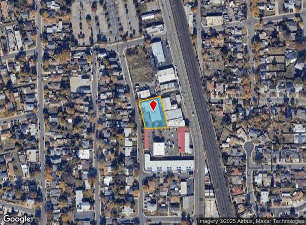
Property Record
4331 Attawa Ave, Sacramento, CA 95822
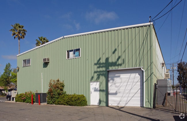
This Property Is For Sale
NEARBY LISTINGS FOR SALE OR LEASE
Property Detail
4331 Attawa Ave
Sacramento--Roseville--Arden-Arcade, CA
Plat Of Terminal Tract
018-0053-042
LOTS 122,123,124,125,126&127 OF TERMINAL TRACT (RM11-14)
Lightindustrial
Sacramento
X
California
06067C0190H
123
2024
0.56 AC
2025
South Sacramento
003800
Sacramento
15,125 SF
DEMOGRAPHICS near 4331 Attawa Ave
1 Mile
3 Mile
5 Mile
2024 Total Population
18,198
170,023
405,255
2029 Population
18,391
171,775
409,296
Pop Growth 2024-2029
+ 1.06%
+ 1.03%
+ 1.00%
Average Age
40
39
39
2024 Total Households
7,263
70,281
154,439
HH Growth 2024-2029
+ 1.06%
+ 1.13%
+ 1.15%
Median Household Inc
$80,261
$71,770
$70,991
Avg Household Size
2.40
2.30
2.50
2024 Avg HH Vehicles
2.00
2.00
2.00
Median Home Value
$484,718
$529,484
$473,492
Median Year Built
1952
1958
1968
Nearby Places
- Restaurants
- Banks
- Shops
- Fitness
- Groceries
PUBLIC TRANSPORTATION
TRANSIT/SUBWAY
City College (Blue Line - Sacramento Regional Transit District Light Rail (The RT))
DRIVE
WALK
Distance
City College (Blue Line - Sacramento Regional Transit District Light Rail (The RT))
4 min
11 min
0.6 mi
Fruitridge (Blue Line - Sacramento Regional Transit District Light Rail (The RT))
DRIVE
WALK
Distance
Fruitridge (Blue Line - Sacramento Regional Transit District Light Rail (The RT))
3 min
20 min
1.1 mi
COMMUTER RAIL
Sacramento (Capitol Corridor - Capitol Corridor Joint Powers Authority)
DRIVE
WALK
Distance
Sacramento (Capitol Corridor - Capitol Corridor Joint Powers Authority)
10 min
5.5 mi
AIRPORT
Sacramento International
DRIVE
WALK
Distance
Sacramento International
24 min
15.8 mi
Freight Ports
Port of Stockton
DRIVE
WALK
Distance
Port of Stockton
54 min
45.2 mi
Nearby Properties
Address
Land Use
TOTAL SIZE
Lot Size
Zoning
Address
Land Use
TOTAL SIZE
Lot Size
Zoning
1,095,507 SF
1.39 AC
H-SPD C-2-
Address
Land Use
TOTAL SIZE
Lot Size
Zoning
10.28 AC
H
Address
Land Use
TOTAL SIZE
Lot Size
Zoning
299,943 SF
4.95 AC
H
Address
Land Use
TOTAL SIZE
Lot Size
Zoning
1.33 AC
R-1
Address
Land Use
TOTAL SIZE
Lot Size
Zoning
756,831 SF
1.39 AC
C-2-SPD
Address
Land Use
TOTAL SIZE
Lot Size
Zoning
1.15 AC
R-1
Address
Land Use
TOTAL SIZE
Lot Size
Zoning
366,730 SF
0.89 AC
C-3-SPD
Address
Land Use
TOTAL SIZE
Lot Size
Zoning
200,616 SF
2.54 AC
C-2-SPD
Address
Land Use
TOTAL SIZE
Lot Size
Zoning
339,329 SF
6.40 AC
R-5-PUD-SP
Address
Land Use
TOTAL SIZE
Lot Size
Zoning
410,420 SF
0.95 AC
C-3-SPD
Address
Land Use
TOTAL SIZE
Lot Size
Zoning
320,072 SF
2.65 AC
C-2
Address
Land Use
TOTAL SIZE
Lot Size
Zoning
R-4-PUD C-
Address
Land Use
TOTAL SIZE
Lot Size
Zoning
26,712 SF
1.90 AC
R-5-PUD-SP
Address
Land Use
TOTAL SIZE
Lot Size
Zoning
26,712 SF
1.85 AC
R-5-PUD-SP
Address
Land Use
TOTAL SIZE
Lot Size
Zoning
1.04 AC
C-2-SPD
Address
Land Use
TOTAL SIZE
Lot Size
Zoning
576,291 SF
C-3-SPD
Address
Land Use
TOTAL SIZE
Lot Size
Zoning
2.59 AC
OB-R
Address
Land Use
TOTAL SIZE
Lot Size
Zoning
122,425 SF
0.59 AC
C-2-SPD
Address
Land Use
TOTAL SIZE
Lot Size
Zoning
926 SF
0.07 AC
C-2-SPD
Address
Land Use
TOTAL SIZE
Lot Size
Zoning
240,548 SF
0.86 AC
C-3-SPD
Address
Land Use
TOTAL SIZE
Lot Size
Zoning
R-4-PUD
Address
Land Use
TOTAL SIZE
Lot Size
Zoning
1.15 AC
R-1
Address
Land Use
TOTAL SIZE
Lot Size
Zoning
171,926 SF
0.34 AC
C-3-SPD
Address
Land Use
TOTAL SIZE
Lot Size
Zoning
280,519 SF
2.50 AC
C-2-SPD
Address
Land Use
TOTAL SIZE
Lot Size
Zoning
258,252 SF
1.66 AC
C-2-SPD
Address
Land Use
TOTAL SIZE
Lot Size
Zoning
141,251 SF
4.86 AC
C-2-SPD RM
Address
Land Use
TOTAL SIZE
Lot Size
Zoning
112,154 SF
1.18 AC
RMX-PUD-SP
Address
Land Use
TOTAL SIZE
Lot Size
Zoning
215,655 SF
0.59 AC
C-3-SPD
Address
Land Use
TOTAL SIZE
Lot Size
Zoning
88,400 SF
1.18 AC
OB-PUD-SPD
Address
Land Use
TOTAL SIZE
Lot Size
Zoning
91,185 SF
1.37 AC
C-2-SPD
The World's #1 Commercial Real Estate Marketplace
Connect with us
© 2025 CoStar Group
The information above has been obtained from sources believed reliable. While we do not doubt its accuracy we have not verified it and make no guarantee, warranty or representation about it. It is your responsibility to independently confirm its accuracy and completeness. Any projections, opinions, assumptions, or estimates used are for example only and do not represent the current or future performance of the property. The value of this transaction to you depends on tax and other factors which should be evaluated by your tax, financial, and legal advisors. You and your advisors should conduct a careful, independent investigation of the property to determine to your satisfaction the suitability of the property for your needs.