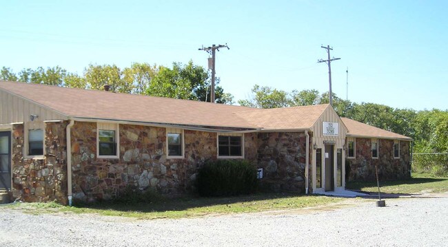
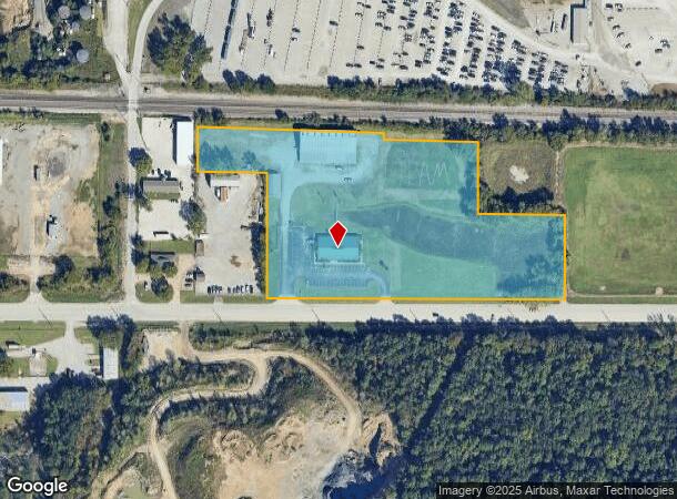
Property Record
4333 W 21St St, Tulsa, OK 74107
NEARBY LISTINGS FOR SALE OR LEASE
Property Detail
4333 W 21St St
99209-92-09-34600
Unplatted
Officebuilding
5BEG 50N &70W SECR SE SW TH N238.05 WLY251.77 N226 TO SL RR R/W TH WLY ALG R/W 804.64 S132.44 E199.16 S357.45 E853.22 POB LESS BEG 511.56N & 321.44W SECR SE TH S25 W273.14 N20 W531.50 N5 E804.64 POB SEC 9 19 12 8.340ACS
X
Tulsa
40113C1245K
Oklahoma
2025
8.34 AC
2025
West
006600
Tulsa
23,312 SF
Tulsa, OK
DEMOGRAPHICS near 4333 W 21St St
1 Mile
3 Mile
5 Mile
2024 Total Population
1,037
30,913
101,959
2029 Population
1,093
32,325
106,394
Pop Growth 2024-2029
+ 5.40%
+ 4.57%
+ 4.35%
Average Age
39
40
40
2024 Total Households
416
14,181
44,632
HH Growth 2024-2029
+ 5.53%
+ 4.82%
+ 4.57%
Median Household Inc
$54,047
$45,258
$51,697
Avg Household Size
2.40
2.10
2.20
2024 Avg HH Vehicles
2.00
2.00
2.00
Median Home Value
$70,535
$111,266
$168,893
Median Year Built
1952
1963
1961
Nearby Places
Map Layers
Map Styles
 Street
 Aerial
- Restaurants
- Banks
- Shops
- Fitness
- Groceries
PUBLIC TRANSPORTATION
AIRPORT
Tulsa International
DRIVE
WALK
Distance
Tulsa International
22 min
12.9 mi
Freight Ports
DRIVE
WALK
Distance
31 min
22.1 mi
Nearby Properties
Address
Land Use
TOTAL SIZE
Lot Size
Zoning
Address
Land Use
TOTAL SIZE
Lot Size
Zoning
565,000 SF
10.62 AC
CBD
Address
Land Use
TOTAL SIZE
Lot Size
Zoning
249,092 SF
11.75 AC
CBD
Address
Land Use
TOTAL SIZE
Lot Size
Zoning
423,825 SF
23.97 AC
CBD
Address
Land Use
TOTAL SIZE
Lot Size
Zoning
483,697 SF
5.31 AC
CBD
Address
Land Use
TOTAL SIZE
Lot Size
Zoning
74,284 SF
3.61 AC
IM
Address
Land Use
TOTAL SIZE
Lot Size
Zoning
132,305 SF
2.07 AC
CBD
Address
Land Use
TOTAL SIZE
Lot Size
Zoning
124,033 SF
4.18 AC
CBD
Address
Land Use
TOTAL SIZE
Lot Size
Zoning
315,434 SF
2.07 AC
CBD
Address
Land Use
TOTAL SIZE
Lot Size
Zoning
355,620 SF
4.78 AC
CBD
Address
Land Use
TOTAL SIZE
Lot Size
Zoning
84,560 SF
1.92 AC
CBD
Address
Land Use
TOTAL SIZE
Lot Size
Zoning
410,400 SF
1.76 AC
CBD
Address
Land Use
TOTAL SIZE
Lot Size
Zoning
137,215 SF
5.08 AC
RM3
Address
Land Use
TOTAL SIZE
Lot Size
Zoning
236,413 SF
2.07 AC
CBD
Address
Land Use
TOTAL SIZE
Lot Size
Zoning
112,506 SF
2.14 AC
CBD
Address
Land Use
TOTAL SIZE
Lot Size
Zoning
88,702 SF
8.27 AC
IM
Address
Land Use
TOTAL SIZE
Lot Size
Zoning
21,693 SF
4.24 AC
Address
Land Use
TOTAL SIZE
Lot Size
Zoning
157,736 SF
56.74 AC
RS3
Address
Land Use
TOTAL SIZE
Lot Size
Zoning
106,743 SF
4.34 AC
MX1U55
Address
Land Use
TOTAL SIZE
Lot Size
Zoning
102,092 SF
0.96 AC
CBD
Address
Land Use
TOTAL SIZE
Lot Size
Zoning
174,776 SF
9.46 AC
RM2
Address
Land Use
TOTAL SIZE
Lot Size
Zoning
89,640 SF
5.47 AC
MX1U55
Address
Land Use
TOTAL SIZE
Lot Size
Zoning
100,857 SF
4.04 AC
MX1U55
Address
Land Use
TOTAL SIZE
Lot Size
Zoning
78,442 SF
31.24 AC
IM
Address
Land Use
TOTAL SIZE
Lot Size
Zoning
589,648 SF
2.84 AC
RM3
Address
Land Use
TOTAL SIZE
Lot Size
Zoning
11,349 SF
0.61 AC
RM2
Address
Land Use
TOTAL SIZE
Lot Size
Zoning
66,355 SF
3.06 AC
CBD
Address
Land Use
TOTAL SIZE
Lot Size
Zoning
497,385 SF
0.79 AC
CBD
Address
Land Use
TOTAL SIZE
Lot Size
Zoning
1,123,266 SF
87.29 AC
IM
Address
Land Use
TOTAL SIZE
Lot Size
Zoning
21,715 SF
1.62 AC
CBD
Address
Land Use
TOTAL SIZE
Lot Size
Zoning
32,827 SF
4.22 AC
CS
The World's #1 Commercial Real Estate Marketplace
Connect with us
© 2025 CoStar Group
The information above has been obtained from sources believed reliable. While we do not doubt its accuracy we have not verified it and make no guarantee, warranty or representation about it. It is your responsibility to independently confirm its accuracy and completeness. Any projections, opinions, assumptions, or estimates used are for example only and do not represent the current or future performance of the property. The value of this transaction to you depends on tax and other factors which should be evaluated by your tax, financial, and legal advisors. You and your advisors should conduct a careful, independent investigation of the property to determine to your satisfaction the suitability of the property for your needs.