Property Record
4334 Daentl Rd, Deforest, WI 53532
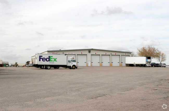

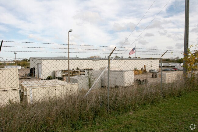
Property Detail
4334 Daentl Rd
Madison, WI
LOT 1 CSM 13902 CS92/201&204-2/17/2015 F/K/A LOTS 3 & 4 CSM 6366 CS31/25&27-4/1/ 91 & ALSO F/K/A LOTS 1 & 2 CSM 6358 CS31/11&13-3/21/91 DESCR AS SEC 5-8-10 PRT N W1/4SE1/4, PRT NE1/4SW1/4, PRT NW1/4SW1/4, PRT SE1/4NW1/4 & PRT SW1/4NW1/4 (26.7 34 ACRE
0810-053-8350-0
Dane
Commercialnec
Wisconsin
ETZ
1,3,4
B and X Area of moderate flood hazard, usually the area between the limits of the 100-year and 500-year floods.
26.73 AC
2025
Northeast Madison
2025
Milwaukee/Madison
011201
NEARBY LISTINGS FOR SALE OR LEASE
DEMOGRAPHICS near 4334 Daentl Rd
1 mile
3 mile
5 mile
2025 Total Population
765
15,831
77,597
2030 Population
787
16,657
80,812
Pop Growth 2025-2030
+ 2.88%
+ 5.22%
+ 4.14%
Average Age
41
40
39
2025 Total Households
309
6,170
32,149
HH Growth 2025-2030
+ 2.91%
+ 5.46%
+ 4.44%
Median Household Inc
$112,500
$106,082
$86,967
Avg Household Size
2.40
2.50
2.40
2025 Avg HH Vehicles
2.00
2.00
2.00
Median Home Value
$397,272
$433,380
$366,358
Median Year Built
1980
1993
1990
Nearby Places
Map Layers
Map Styles
 Street
 Aerial
Layers
 Traffic
 Biking
Places
Listings with unknown addresses are not visible on the map
- Restaurants
- Banks
- Shops
- Fitness
- Groceries
PUBLIC TRANSPORTATION
AIRPORT
Dane County Regional/Truax Field
Drive
Walk
Distance
Dane County Regional/Truax Field
13 min
5.9 mi
Nearby Properties
Address
Land Use
TOTAL SIZE
Lot Size
Zoning
Address
Land Use
TOTAL SIZE
Lot Size
Zoning
385,400 SF
62.07 AC
IL
Address
Land Use
TOTAL SIZE
Lot Size
Zoning
48.24 AC
Address
Land Use
TOTAL SIZE
Lot Size
Zoning
107,751 SF
22.34 AC
IL
Address
Land Use
TOTAL SIZE
Lot Size
Zoning
912,762 SF
24.28 AC
SEC
Address
Land Use
TOTAL SIZE
Lot Size
Zoning
Address
Land Use
TOTAL SIZE
Lot Size
Zoning
37.54 AC
Address
Land Use
TOTAL SIZE
Lot Size
Zoning
443,828 SF
25.96 AC
SEC
Address
Land Use
TOTAL SIZE
Lot Size
Zoning
737,119 SF
59.57 AC
SEC
Address
Land Use
TOTAL SIZE
Lot Size
Zoning
24.70 AC
Address
Land Use
TOTAL SIZE
Lot Size
Zoning
282,902 SF
24.96 AC
SEC
Address
Land Use
TOTAL SIZE
Lot Size
Zoning
Address
Land Use
TOTAL SIZE
Lot Size
Zoning
Address
Land Use
TOTAL SIZE
Lot Size
Zoning
3.77 AC
Address
Land Use
TOTAL SIZE
Lot Size
Zoning
16.64 AC
Address
Land Use
TOTAL SIZE
Lot Size
Zoning
62,705 SF
11.48 AC
SEC
Address
Land Use
TOTAL SIZE
Lot Size
Zoning
8.19 AC
Address
Land Use
TOTAL SIZE
Lot Size
Zoning
5.57 AC
Address
Land Use
TOTAL SIZE
Lot Size
Zoning
11.01 AC
C2
Address
Land Use
TOTAL SIZE
Lot Size
Zoning
13.27 AC
ETZ
Address
Land Use
TOTAL SIZE
Lot Size
Zoning
137,665 SF
9.39 AC
IL
Address
Land Use
TOTAL SIZE
Lot Size
Zoning
3.60 AC
Address
Land Use
TOTAL SIZE
Lot Size
Zoning
2.60 AC
Address
Land Use
TOTAL SIZE
Lot Size
Zoning
20.59 AC
C2
Address
Land Use
TOTAL SIZE
Lot Size
Zoning
139,673 SF
14.08 AC
IL
Address
Land Use
TOTAL SIZE
Lot Size
Zoning
33.67 AC
Address
Land Use
TOTAL SIZE
Lot Size
Zoning
3.76 AC
R-4
Address
Land Use
TOTAL SIZE
Lot Size
Zoning
2.56 AC
Address
Land Use
TOTAL SIZE
Lot Size
Zoning
6.97 AC
Address
Land Use
TOTAL SIZE
Lot Size
Zoning
122,038 SF
9.03 AC
IL
Address
Land Use
TOTAL SIZE
Lot Size
Zoning
51,670 SF
3.40 AC
SEC
The World's #1 Commercial Real Estate Marketplace
Connect with us
© 2026 CoStar Group
The information above has been obtained from sources believed reliable. While we do not doubt its accuracy we have not verified it and make no guarantee, warranty or representation about it. It is your responsibility to independently confirm its accuracy and completeness. Any projections, opinions, assumptions, or estimates used are for example only and do not represent the current or future performance of the property. The value of this transaction to you depends on tax and other factors which should be evaluated by your tax, financial, and legal advisors. You and your advisors should conduct a careful, independent investigation of the property to determine to your satisfaction the suitability of the property for your needs.