Property Record
4335 Highway 36 S, Rosenberg, TX 77471
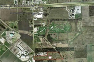
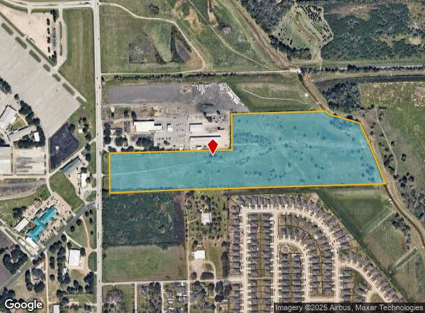
Property Detail
4335 Highway 36 S
Houston-Pasadena-The Woodlands, TX
0312 G M STONE, ACRES 32.532, BLOCK 1, LAMAR CONSOLIDATED ISD TRANSPORTATION CENTER, RESTRICTED RESERVE A (NON-RESIDENTIAL)
0312-00-000-0161-901
FORT BEND
Taxexempt
Texas
AE The base floodplain where base flood elevations are provided. AE Zones are now used on new format FIRMs instead of A1-A30 Zones.
16
0
33 AC
2025
Southwest Outlier
675501
Houston
NEARBY LISTINGS FOR SALE OR LEASE
DEMOGRAPHICS near 4335 Highway 36 S
1 mile
3 mile
5 mile
2025 Total Population
4,060
42,636
92,025
2030 Population
4,652
48,691
105,621
Pop Growth 2025-2030
+ 14.58%
+ 14.20%
+ 14.77%
Average Age
33
37
37
2025 Total Households
1,241
13,972
30,567
HH Growth 2025-2030
+ 14.99%
+ 14.59%
+ 15.18%
Median Household Inc
$81,828
$72,091
$78,395
Avg Household Size
3.30
3.00
2.90
2025 Avg HH Vehicles
2.00
2.00
2.00
Median Home Value
$253,428
$241,923
$293,380
Median Year Built
2010
2002
2009
Nearby Places
Map Layers
Map Styles
 Street
 Aerial
Layers
 Traffic
 Biking
Places
Listings with unknown addresses are not visible on the map
- Restaurants
- Banks
- Shops
- Fitness
- Groceries
Nearby Properties
Address
Land Use
TOTAL SIZE
Lot Size
Zoning
Address
Land Use
TOTAL SIZE
Lot Size
Zoning
44.35 AC
YOSN
Address
Land Use
TOTAL SIZE
Lot Size
Zoning
672,112 SF
81.77 AC
YHN
Address
Land Use
TOTAL SIZE
Lot Size
Zoning
283,393 SF
93.42 AC
Address
Land Use
TOTAL SIZE
Lot Size
Zoning
17.73 AC
Address
Land Use
TOTAL SIZE
Lot Size
Zoning
11.40 AC
Address
Land Use
TOTAL SIZE
Lot Size
Zoning
Address
Land Use
TOTAL SIZE
Lot Size
Zoning
98,691 SF
29.37 AC
Address
Land Use
TOTAL SIZE
Lot Size
Zoning
16.23 AC
Address
Land Use
TOTAL SIZE
Lot Size
Zoning
Address
Land Use
TOTAL SIZE
Lot Size
Zoning
54,406 SF
13.13 AC
Address
Land Use
TOTAL SIZE
Lot Size
Zoning
18.86 AC
Address
Land Use
TOTAL SIZE
Lot Size
Zoning
96,992 SF
14.76 AC
SM
Address
Land Use
TOTAL SIZE
Lot Size
Zoning
64.02 AC
YQ
Address
Land Use
TOTAL SIZE
Lot Size
Zoning
1,216 SF
24.38 AC
YZS
Address
Land Use
TOTAL SIZE
Lot Size
Zoning
Address
Land Use
TOTAL SIZE
Lot Size
Zoning
66,896 SF
18.60 AC
ZNY
Address
Land Use
TOTAL SIZE
Lot Size
Zoning
25.69 AC
Address
Land Use
TOTAL SIZE
Lot Size
Zoning
61.31 AC
MY
Address
Land Use
TOTAL SIZE
Lot Size
Zoning
4,524 SF
13.68 AC
Address
Land Use
TOTAL SIZE
Lot Size
Zoning
54,028 SF
9.26 AC
Address
Land Use
TOTAL SIZE
Lot Size
Zoning
37,951 SF
5.39 AC
L
Address
Land Use
TOTAL SIZE
Lot Size
Zoning
145,000 SF
17.36 AC
YSNM
Address
Land Use
TOTAL SIZE
Lot Size
Zoning
30.57 AC
Address
Land Use
TOTAL SIZE
Lot Size
Zoning
8.01 AC
Address
Land Use
TOTAL SIZE
Lot Size
Zoning
7.16 AC
Address
Land Use
TOTAL SIZE
Lot Size
Zoning
14.18 AC
Address
Land Use
TOTAL SIZE
Lot Size
Zoning
4.20 AC
YS
Address
Land Use
TOTAL SIZE
Lot Size
Zoning
23,133 SF
8.93 AC
S
Address
Land Use
TOTAL SIZE
Lot Size
Zoning
133,826 SF
11.60 AC
Address
Land Use
TOTAL SIZE
Lot Size
Zoning
45,695 SF
3.38 AC
XY
The World's #1 Commercial Real Estate Marketplace
Connect with us
© 2026 CoStar Group
The information above has been obtained from sources believed reliable. While we do not doubt its accuracy we have not verified it and make no guarantee, warranty or representation about it. It is your responsibility to independently confirm its accuracy and completeness. Any projections, opinions, assumptions, or estimates used are for example only and do not represent the current or future performance of the property. The value of this transaction to you depends on tax and other factors which should be evaluated by your tax, financial, and legal advisors. You and your advisors should conduct a careful, independent investigation of the property to determine to your satisfaction the suitability of the property for your needs.