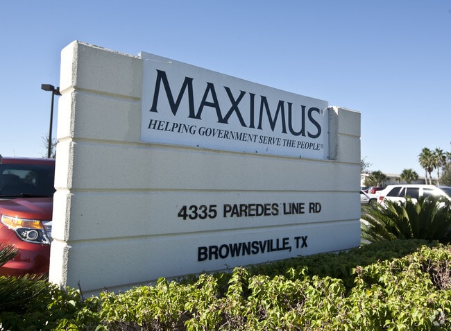
Property Record
4335 Paredes Line Rd, Brownsville, TX 78526

NEARBY LISTINGS FOR SALE OR LEASE
Property Detail
4335 Paredes Line Rd
Brownsville-Harlingen, TX
Project Pierce Subdivision
792242-0010-001000
LOT 1 BLK 1 PROJECT PIERCE SUBDIVISION (C1-2817A CCMR FILED 5-18-07)
Commercialnec
Cameron
AH
Texas
48061C0580F
1
2024
9.18 AC
2025
Greater Brownsville
014501
Brownsville/Harlingen
78,701 SF
DEMOGRAPHICS near 4335 Paredes Line Rd
1 Mile
3 Mile
5 Mile
2024 Total Population
16,256
86,805
179,619
2029 Population
16,388
88,621
184,020
Pop Growth 2024-2029
+ 0.81%
+ 2.09%
+ 2.45%
Average Age
36
36
35
2024 Total Households
4,928
27,754
55,652
HH Growth 2024-2029
+ 0.89%
+ 2.13%
+ 2.46%
Median Household Inc
$64,250
$57,981
$49,260
Avg Household Size
3.20
3.10
3.10
2024 Avg HH Vehicles
2.00
2.00
2.00
Median Home Value
$141,813
$140,249
$109,301
Median Year Built
1996
1996
1992
Nearby Places
Map Layers
Map Styles
 Street
 Aerial
- Restaurants
- Banks
- Shops
- Fitness
- Groceries
PUBLIC TRANSPORTATION
AIRPORT
Brownsville/South Padre Island International
DRIVE
WALK
Distance
Brownsville/South Padre Island International
15 min
7.2 mi
Valley International
DRIVE
WALK
Distance
Valley International
35 min
25.4 mi
Freight Ports
Port of Brownsville
DRIVE
WALK
Distance
Port of Brownsville
11 min
7.2 mi
Nearby Properties
Address
Land Use
TOTAL SIZE
Lot Size
Zoning
Address
Land Use
TOTAL SIZE
Lot Size
Zoning
319,798 SF
46.28 AC
Address
Land Use
TOTAL SIZE
Lot Size
Zoning
1,019,535 SF
83.42 AC
I
Address
Land Use
TOTAL SIZE
Lot Size
Zoning
452,559 SF
13.79 AC
C
Address
Land Use
TOTAL SIZE
Lot Size
Zoning
232,467 SF
25.82 AC
C
Address
Land Use
TOTAL SIZE
Lot Size
Zoning
112,834 SF
16.70 AC
C
Address
Land Use
TOTAL SIZE
Lot Size
Zoning
135,686 SF
19.05 AC
C
Address
Land Use
TOTAL SIZE
Lot Size
Zoning
196,847 SF
19.63 AC
Address
Land Use
TOTAL SIZE
Lot Size
Zoning
286,243 SF
19.21 AC
C
Address
Land Use
TOTAL SIZE
Lot Size
Zoning
72,436 SF
22.08 AC
Address
Land Use
TOTAL SIZE
Lot Size
Zoning
100,491 SF
14 AC
C
Address
Land Use
TOTAL SIZE
Lot Size
Zoning
66,340 SF
3.85 AC
C
Address
Land Use
TOTAL SIZE
Lot Size
Zoning
132,197 SF
10.70 AC
Address
Land Use
TOTAL SIZE
Lot Size
Zoning
56,804 SF
1.83 AC
Address
Land Use
TOTAL SIZE
Lot Size
Zoning
73,090 SF
3.08 AC
C
Address
Land Use
TOTAL SIZE
Lot Size
Zoning
148,781 SF
10.28 AC
B
Address
Land Use
TOTAL SIZE
Lot Size
Zoning
213,521 SF
38.75 AC
Address
Land Use
TOTAL SIZE
Lot Size
Zoning
60,747 SF
2.59 AC
C
Address
Land Use
TOTAL SIZE
Lot Size
Zoning
4.56 AC
C
Address
Land Use
TOTAL SIZE
Lot Size
Zoning
188,446 SF
18.42 AC
Address
Land Use
TOTAL SIZE
Lot Size
Zoning
62,344 SF
2.92 AC
Address
Land Use
TOTAL SIZE
Lot Size
Zoning
204,001 SF
20.13 AC
C
Address
Land Use
TOTAL SIZE
Lot Size
Zoning
52,668 SF
2.23 AC
Address
Land Use
TOTAL SIZE
Lot Size
Zoning
120,166 SF
12.33 AC
Address
Land Use
TOTAL SIZE
Lot Size
Zoning
102,042 SF
8.68 AC
C
Address
Land Use
TOTAL SIZE
Lot Size
Zoning
176,990 SF
18.31 AC
C
Address
Land Use
TOTAL SIZE
Lot Size
Zoning
78,583 SF
5.01 AC
C
Address
Land Use
TOTAL SIZE
Lot Size
Zoning
110,431 SF
15 AC
Address
Land Use
TOTAL SIZE
Lot Size
Zoning
112,263 SF
9.66 AC
Address
Land Use
TOTAL SIZE
Lot Size
Zoning
80,480 SF
10.68 AC
The World's #1 Commercial Real Estate Marketplace
Connect with us
© 2026 CoStar Group
The information above has been obtained from sources believed reliable. While we do not doubt its accuracy we have not verified it and make no guarantee, warranty or representation about it. It is your responsibility to independently confirm its accuracy and completeness. Any projections, opinions, assumptions, or estimates used are for example only and do not represent the current or future performance of the property. The value of this transaction to you depends on tax and other factors which should be evaluated by your tax, financial, and legal advisors. You and your advisors should conduct a careful, independent investigation of the property to determine to your satisfaction the suitability of the property for your needs.