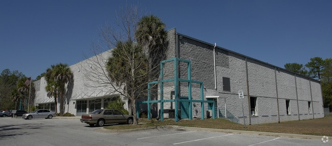
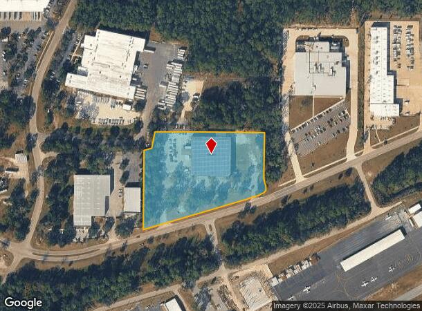
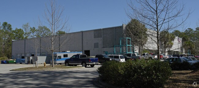
Property Record
4340 Ne 49Th Ave, Gainesville, FL 32609

NEARBY LISTINGS FOR SALE OR LEASE
Property Detail
4340 Ne 49Th Ave
Gainesville, FL
Airport Industrial Park Unit Ii
08162-014-000
AIRPORT INDUSTRIAL PARK UNIT II PB T-37 LOT 14 OR 5115/1416
Lightindustrial
Alachua
X
Florida
12001C0309D
14
2025
5.23 AC
2025
Gainesville
001902
Other Market Areas
32,316 SF
DEMOGRAPHICS near 4340 Ne 49Th Ave
1 Mile
3 Mile
5 Mile
2024 Total Population
324
8,891
45,519
2029 Population
344
9,384
48,313
Pop Growth 2024-2029
+ 6.17%
+ 5.54%
+ 6.14%
Average Age
37
39
38
2024 Total Households
158
3,045
18,795
HH Growth 2024-2029
+ 6.33%
+ 5.48%
+ 6.03%
Median Household Inc
$27,874
$43,243
$40,951
Avg Household Size
2.00
2.50
2.20
2024 Avg HH Vehicles
1.00
1.00
1.00
Median Home Value
$78,571
$124,438
$153,253
Median Year Built
1982
1976
1974
Nearby Places
Map Layers
Map Styles
 Street
 Aerial
- Restaurants
- Banks
- Shops
- Fitness
- Groceries
PUBLIC TRANSPORTATION
AIRPORT
Gainesville Regional
DRIVE
WALK
Distance
Gainesville Regional
10 min
3.3 mi
Freight Ports
Jacksonville Port
DRIVE
WALK
Distance
Jacksonville Port
92 min
70.7 mi
SALE & LEASE HISTORY
LISTING DATE
SALE/LEASE

Nov 22, 2016
For Lease
Nearby Properties
Address
Land Use
TOTAL SIZE
Lot Size
Zoning
Address
Land Use
TOTAL SIZE
Lot Size
Zoning
25.64 AC
PS
Address
Land Use
TOTAL SIZE
Lot Size
Zoning
60,480 SF
117.68 AC
PS
Address
Land Use
TOTAL SIZE
Lot Size
Zoning
308,599 SF
639 AC
A
Address
Land Use
TOTAL SIZE
Lot Size
Zoning
341,625 SF
1,093.63 AC
AF
Address
Land Use
TOTAL SIZE
Lot Size
Zoning
3 SF
14.81 AC
ED
Address
Land Use
TOTAL SIZE
Lot Size
Zoning
93,004 SF
37.39 AC
ED
Address
Land Use
TOTAL SIZE
Lot Size
Zoning
85,476 SF
17.92 AC
MP
Address
Land Use
TOTAL SIZE
Lot Size
Zoning
41,000 SF
155.49 AC
PS
Address
Land Use
TOTAL SIZE
Lot Size
Zoning
177,604 SF
41.41 AC
I2
Address
Land Use
TOTAL SIZE
Lot Size
Zoning
64,138 SF
8.43 AC
I2
Address
Land Use
TOTAL SIZE
Lot Size
Zoning
118,740 SF
11.16 AC
I1
Address
Land Use
TOTAL SIZE
Lot Size
Zoning
154,130 SF
24.65 AC
I2
Address
Land Use
TOTAL SIZE
Lot Size
Zoning
93,651 SF
6.50 AC
RMF6
Address
Land Use
TOTAL SIZE
Lot Size
Zoning
123,764 SF
10.13 AC
PD
Address
Land Use
TOTAL SIZE
Lot Size
Zoning
82,852 SF
8.08 AC
RMF6
Address
Land Use
TOTAL SIZE
Lot Size
Zoning
115,389 SF
9.73 AC
RMF7
Address
Land Use
TOTAL SIZE
Lot Size
Zoning
241,937 SF
16.93 AC
I2
Address
Land Use
TOTAL SIZE
Lot Size
Zoning
26,552 SF
70.03 AC
MH
Address
Land Use
TOTAL SIZE
Lot Size
Zoning
82,394 SF
13.93 AC
I2
Address
Land Use
TOTAL SIZE
Lot Size
Zoning
88,104 SF
60.24 AC
PS
Address
Land Use
TOTAL SIZE
Lot Size
Zoning
2,030 SF
34.88 AC
RM
Address
Land Use
TOTAL SIZE
Lot Size
Zoning
66,014 SF
44.26 AC
PD
Address
Land Use
TOTAL SIZE
Lot Size
Zoning
23 AC
PS
Address
Land Use
TOTAL SIZE
Lot Size
Zoning
41,875 SF
12.97 AC
BA
Address
Land Use
TOTAL SIZE
Lot Size
Zoning
43,584 SF
219.21 AC
PS
Address
Land Use
TOTAL SIZE
Lot Size
Zoning
2,540 SF
13.84 AC
I1
Address
Land Use
TOTAL SIZE
Lot Size
Zoning
63,475 SF
9.42 AC
I2
Address
Land Use
TOTAL SIZE
Lot Size
Zoning
16,356 SF
80 AC
ED
Address
Land Use
TOTAL SIZE
Lot Size
Zoning
77,500 SF
36.72 AC
MP
Address
Land Use
TOTAL SIZE
Lot Size
Zoning
66.89 AC
PS
The World's #1 Commercial Real Estate Marketplace
Connect with us
© 2026 CoStar Group
The information above has been obtained from sources believed reliable. While we do not doubt its accuracy we have not verified it and make no guarantee, warranty or representation about it. It is your responsibility to independently confirm its accuracy and completeness. Any projections, opinions, assumptions, or estimates used are for example only and do not represent the current or future performance of the property. The value of this transaction to you depends on tax and other factors which should be evaluated by your tax, financial, and legal advisors. You and your advisors should conduct a careful, independent investigation of the property to determine to your satisfaction the suitability of the property for your needs.