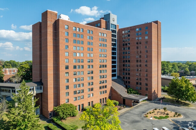
Property Record
4343 Lebanon Pike, Hermitage, TN 37076

NEARBY LISTINGS FOR SALE OR LEASE
-
-
View all Hermitage listings for sale on LoopNet.com
Property Detail
4343 Lebanon Pike
075-06-0-150
S/E COR HIGHLAND VIEW DR& LEB PK-L 231-RES C PT 232 HERM EST
Retirementnursinghomecombined
Davidson
X
Tennessee
47037C0278J
17.91 AC
2025
Outer Donelson-Hermitage
2025
Nashville
015404
Nashville-Davidson--Murfreesboro--Franklin, TN
294,923 SF
DEMOGRAPHICS near 4343 Lebanon Pike
1 Mile
3 Mile
5 Mile
2024 Total Population
6,000
50,003
111,366
2029 Population
5,847
50,760
114,265
Pop Growth 2024-2029
(2.55%)
+ 1.51%
+ 2.60%
Average Age
44
40
41
2024 Total Households
2,464
20,757
45,650
HH Growth 2024-2029
(2.80%)
+ 0.55%
+ 1.52%
Median Household Inc
$65,274
$74,374
$75,646
Avg Household Size
2.30
2.40
2.40
2024 Avg HH Vehicles
2.00
2.00
2.00
Median Home Value
$267,061
$312,503
$327,139
Median Year Built
1976
1990
1986
Nearby Places
Map Layers
Map Styles
 Street
 Aerial
- Restaurants
- Banks
- Shops
- Fitness
- Groceries
PUBLIC TRANSPORTATION
COMMUTER RAIL
Hermitage (East Corridor Line - Tennessee Regional Transportation Authority Music City Star (Music City Star))
DRIVE
WALK
Distance
Hermitage (East Corridor Line - Tennessee Regional Transportation Authority Music City Star (Music City Star))
5 min
1.9 mi
Donelson (East Corridor Line - Tennessee Regional Transportation Authority Music City Star (Music City Star))
DRIVE
WALK
Distance
Donelson (East Corridor Line - Tennessee Regional Transportation Authority Music City Star (Music City Star))
8 min
4.5 mi
AIRPORT
Nashville International
DRIVE
WALK
Distance
Nashville International
14 min
8.2 mi
Freight Ports
Port of Mobile
DRIVE
WALK
Distance
Port of Mobile
498 min
456.3 mi
Nearby Properties
Address
Land Use
TOTAL SIZE
Lot Size
Zoning
Address
Land Use
TOTAL SIZE
Lot Size
Zoning
32,891 SF
10.65 AC
MUL
Address
Land Use
TOTAL SIZE
Lot Size
Zoning
503,878 SF
47.85 AC
OG
Address
Land Use
TOTAL SIZE
Lot Size
Zoning
25,068 SF
42.36 AC
MULTI-ZONE
Address
Land Use
TOTAL SIZE
Lot Size
Zoning
102,162 SF
25.71 AC
RM9
Address
Land Use
TOTAL SIZE
Lot Size
Zoning
75,873 SF
8.88 AC
OR20
Address
Land Use
TOTAL SIZE
Lot Size
Zoning
21,061 SF
31.15 AC
RM9
Address
Land Use
TOTAL SIZE
Lot Size
Zoning
12,312 SF
21.51 AC
OR20
Address
Land Use
TOTAL SIZE
Lot Size
Zoning
10,280 SF
32.07 AC
RM15
Address
Land Use
TOTAL SIZE
Lot Size
Zoning
18,522 SF
22.42 AC
MULTI-ZONE
Address
Land Use
TOTAL SIZE
Lot Size
Zoning
52,305 SF
25.71 AC
MULTI-ZONE
Address
Land Use
TOTAL SIZE
Lot Size
Zoning
15,750 SF
19.47 AC
RM15
Address
Land Use
TOTAL SIZE
Lot Size
Zoning
49,140 SF
17.93 AC
OL
Address
Land Use
TOTAL SIZE
Lot Size
Zoning
23,328 SF
13.48 AC
RM20
Address
Land Use
TOTAL SIZE
Lot Size
Zoning
64,560 SF
8.57 AC
MULTIZONE
Address
Land Use
TOTAL SIZE
Lot Size
Zoning
81,811 SF
8.95 AC
MULTI-ZONE
Address
Land Use
TOTAL SIZE
Lot Size
Zoning
21,580 SF
20.29 AC
RM9
Address
Land Use
TOTAL SIZE
Lot Size
Zoning
19,120 SF
22.25 AC
RM15
Address
Land Use
TOTAL SIZE
Lot Size
Zoning
37,050 SF
8.78 AC
OR20
Address
Land Use
TOTAL SIZE
Lot Size
Zoning
16,890 SF
8.28 AC
CS
Address
Land Use
TOTAL SIZE
Lot Size
Zoning
4,500 SF
7.76 AC
R20
Address
Land Use
TOTAL SIZE
Lot Size
Zoning
13,616 SF
14.96 AC
MULTI-ZONE
Address
Land Use
TOTAL SIZE
Lot Size
Zoning
2,914 SF
9.92 AC
RS15
Address
Land Use
TOTAL SIZE
Lot Size
Zoning
11,875 SF
21.25 AC
RM9
Address
Land Use
TOTAL SIZE
Lot Size
Zoning
11,508 SF
17.07 AC
RM15
Address
Land Use
TOTAL SIZE
Lot Size
Zoning
30,690 SF
10.95 AC
RM9
Address
Land Use
TOTAL SIZE
Lot Size
Zoning
139,464 SF
0.58 AC
OG: OFF SE
Address
Land Use
TOTAL SIZE
Lot Size
Zoning
121,795 SF
9.96 AC
OL
Address
Land Use
TOTAL SIZE
Lot Size
Zoning
29,201 SF
5.86 AC
RS15
Address
Land Use
TOTAL SIZE
Lot Size
Zoning
9,990 SF
13.19 AC
R10
The World's #1 Commercial Real Estate Marketplace
Connect with us
© 2026 CoStar Group
The information above has been obtained from sources believed reliable. While we do not doubt its accuracy we have not verified it and make no guarantee, warranty or representation about it. It is your responsibility to independently confirm its accuracy and completeness. Any projections, opinions, assumptions, or estimates used are for example only and do not represent the current or future performance of the property. The value of this transaction to you depends on tax and other factors which should be evaluated by your tax, financial, and legal advisors. You and your advisors should conduct a careful, independent investigation of the property to determine to your satisfaction the suitability of the property for your needs.