Property Record
4343 Whitaker Ave, Philadelphia, PA 19124
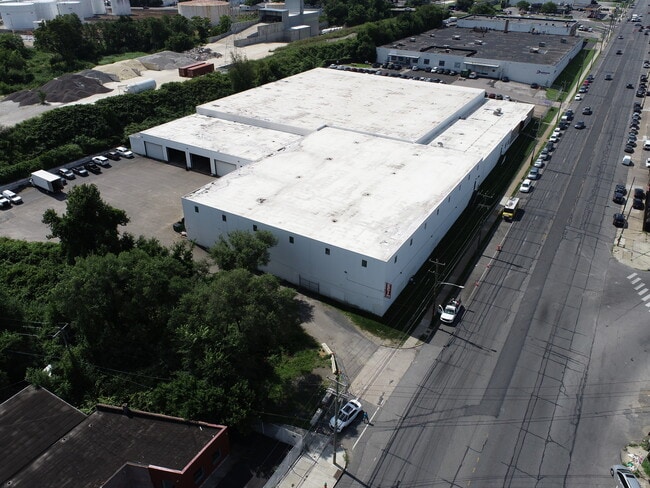
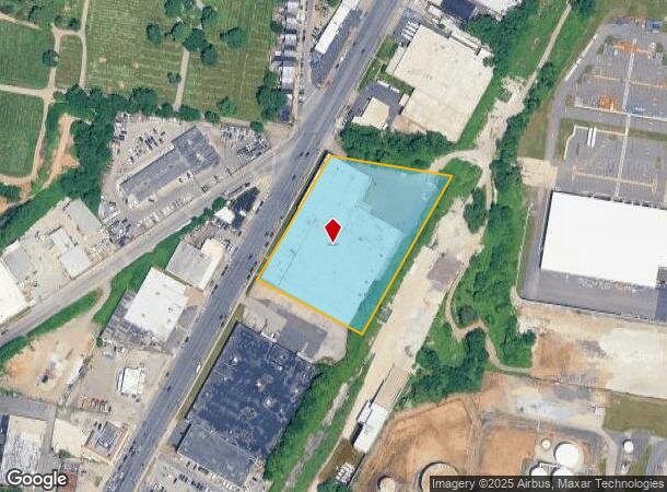
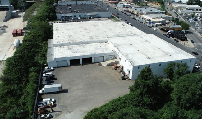

This Property Is For Sale
NEARBY LISTINGS FOR SALE OR LEASE
Property Detail
4343 Whitaker Ave
884184500
SE C CAYUGA ST
Warehouse
Philadelphia
X
Pennsylvania
4207570113G
112
2024
3.32 AC
2026
Kensington
028901
Philadelphia
93,571 SF
Philadelphia-Camden-Wilmington, PA-NJ-DE-MD
DEMOGRAPHICS near 4343 Whitaker Ave
1 Mile
3 Mile
5 Mile
2024 Total Population
34,666
412,416
906,581
2029 Population
32,934
398,347
881,289
Pop Growth 2024-2029
(5.00%)
(3.41%)
(2.79%)
Average Age
36
37
37
2024 Total Households
11,270
151,373
354,822
HH Growth 2024-2029
(5.25%)
(3.57%)
(2.90%)
Median Household Inc
$35,541
$38,667
$49,580
Avg Household Size
2.90
2.60
2.40
2024 Avg HH Vehicles
1.00
1.00
1.00
Median Home Value
$113,148
$147,007
$188,727
Median Year Built
1947
1947
1949
Nearby Places
- Restaurants
- Banks
- Shops
- Fitness
- Groceries
PUBLIC TRANSPORTATION
COMMUTER RAIL
Olney (R8 - Southeastern Pennsylvania Transportation Authority Regional Rail (SEPTA Regional Rail))
DRIVE
WALK
Distance
Olney (R8 - Southeastern Pennsylvania Transportation Authority Regional Rail (SEPTA Regional Rail))
6 min
1.9 mi
Wayne Junction (R1 - Southeastern Pennsylvania Transportation Authority Regional Rail (SEPTA Regional Rail), R2 - Southeastern Pennsylvania Transportation Authority Regional Rail (SEPTA Regional Rail), R3 - Southeastern Pennsylvania Transportation Authority Regional Rail (SEPTA Regional Rail), R5 - Southeastern Pennsylvania Transportation Authority Regional Rail (SEPTA Regional Rail), R7 - Southeastern Pennsylvania Transportation Authority Regional Rail (SEPTA Regional Rail), R8 - Southeastern Pennsylvania Transportation Authority Regional Rail (SEPTA Regional Rail))
DRIVE
WALK
Distance
Wayne Junction (R1 - Southeastern Pennsylvania Transportation Authority Regional Rail (SEPTA Regional Rail), R2 - Southeastern Pennsylvania Transportation Authority Regional Rail (SEPTA Regional Rail), R3 - Southeastern Pennsylvania Transportation Authority Regional Rail (SEPTA Regional Rail), R5 - Southeastern Pennsylvania Transportation Authority Regional Rail (SEPTA Regional Rail), R7 - Southeastern Pennsylvania Transportation Authority Regional Rail (SEPTA Regional Rail), R8 - Southeastern Pennsylvania Transportation Authority Regional Rail (SEPTA Regional Rail))
7 min
2.8 mi
AIRPORT
Philadelphia International
DRIVE
WALK
Distance
Philadelphia International
31 min
16.6 mi
Trenton Mercer
DRIVE
WALK
Distance
Trenton Mercer
46 min
27.4 mi
Freight Ports
Port of Philadelphia
DRIVE
WALK
Distance
Port of Philadelphia
9 min
4.0 mi
Nearby Properties
Address
Land Use
TOTAL SIZE
Lot Size
Zoning
Address
Land Use
TOTAL SIZE
Lot Size
Zoning
740,701 SF
47.70 AC
I2
Address
Land Use
TOTAL SIZE
Lot Size
Zoning
485,616 SF
8.96 AC
CMX3
Address
Land Use
TOTAL SIZE
Lot Size
Zoning
242,655 SF
3.29 AC
CMX3
Address
Land Use
TOTAL SIZE
Lot Size
Zoning
3,590 SF
50 AC
SPPOA
Address
Land Use
TOTAL SIZE
Lot Size
Zoning
17,886 SF
80 AC
SPPOA
Address
Land Use
TOTAL SIZE
Lot Size
Zoning
164,412 SF
4.44 AC
SPINS
Address
Land Use
TOTAL SIZE
Lot Size
Zoning
425,128 SF
23 AC
RSA5
Address
Land Use
TOTAL SIZE
Lot Size
Zoning
504,972 SF
16.30 AC
RM2
Address
Land Use
TOTAL SIZE
Lot Size
Zoning
500,000 SF
2.30 AC
CMX3
Address
Land Use
TOTAL SIZE
Lot Size
Zoning
238,378 SF
18 AC
CA1
Address
Land Use
TOTAL SIZE
Lot Size
Zoning
235,276 SF
1.88 AC
CMX2.5
Address
Land Use
TOTAL SIZE
Lot Size
Zoning
2,500,000 SF
134.14 AC
I2
Address
Land Use
TOTAL SIZE
Lot Size
Zoning
561,600 SF
11.28 AC
CMX3
Address
Land Use
TOTAL SIZE
Lot Size
Zoning
75,358 SF
24.98 AC
I2
Address
Land Use
TOTAL SIZE
Lot Size
Zoning
237,834 SF
0.96 AC
CMX3
Address
Land Use
TOTAL SIZE
Lot Size
Zoning
172,844 SF
1.04 AC
CMX2.5
Address
Land Use
TOTAL SIZE
Lot Size
Zoning
1,316,610 SF
46.73 AC
I2
Address
Land Use
TOTAL SIZE
Lot Size
Zoning
208,620 SF
19.71 AC
I2
Address
Land Use
TOTAL SIZE
Lot Size
Zoning
404,025 SF
1.21 AC
RM4
Address
Land Use
TOTAL SIZE
Lot Size
Zoning
227,844 SF
19.82 AC
I2
Address
Land Use
TOTAL SIZE
Lot Size
Zoning
210,964 SF
21.28 AC
CMX3
Address
Land Use
TOTAL SIZE
Lot Size
Zoning
526,165 SF
12.68 AC
RSA3
Address
Land Use
TOTAL SIZE
Lot Size
Zoning
363,136 SF
16.47 AC
RSA3
Address
Land Use
TOTAL SIZE
Lot Size
Zoning
233,143 SF
24.24 AC
SPINS
Address
Land Use
TOTAL SIZE
Lot Size
Zoning
5.37 AC
I2
Address
Land Use
TOTAL SIZE
Lot Size
Zoning
251,657 SF
0.99 AC
ICMX
Address
Land Use
TOTAL SIZE
Lot Size
Zoning
1.99 AC
SPINS
Address
Land Use
TOTAL SIZE
Lot Size
Zoning
253,800 SF
0.61 AC
RM1
Address
Land Use
TOTAL SIZE
Lot Size
Zoning
329,300 SF
6.98 AC
RSA5
Address
Land Use
TOTAL SIZE
Lot Size
Zoning
356,056 SF
1.91 AC
CMX3
The World's #1 Commercial Real Estate Marketplace
Connect with us
© 2025 CoStar Group
The information above has been obtained from sources believed reliable. While we do not doubt its accuracy we have not verified it and make no guarantee, warranty or representation about it. It is your responsibility to independently confirm its accuracy and completeness. Any projections, opinions, assumptions, or estimates used are for example only and do not represent the current or future performance of the property. The value of this transaction to you depends on tax and other factors which should be evaluated by your tax, financial, and legal advisors. You and your advisors should conduct a careful, independent investigation of the property to determine to your satisfaction the suitability of the property for your needs.