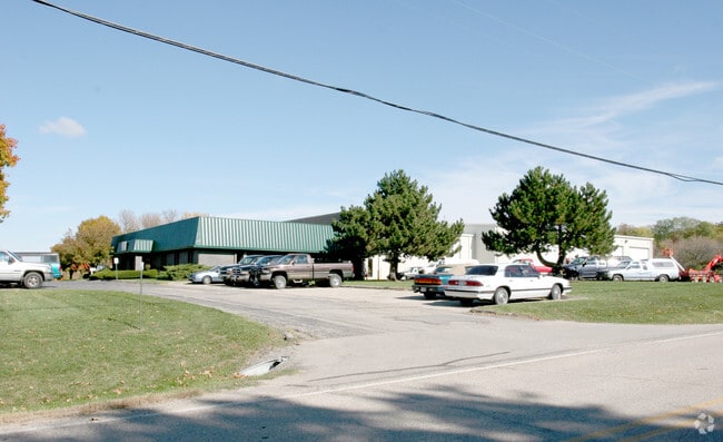
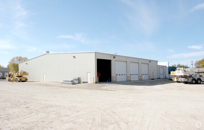
Property Record
4344 Acker Rd, Madison, WI 53704

Property Detail
4344 Acker Rd
Madison, WI
SEC 8-8-10 PRT SW1/4 SE1/4 COM SEC S1/4 COR TH N2DEGE 858.36 FT TO POB TH S85DEG E 693.8 FT TH N5DEGE 458.5 FT TH N85DEGW 715.3 FT TH S2DEGW 452.2 FT TO POB 7.36 A INCLUDING RD R/W & TRIANGLE OF LAND LYG NWLY OF CTH CV
0810-084-9060-3
Dane
Commercialnec
Wisconsin
C-2
60
B and X Area of moderate flood hazard, usually the area between the limits of the 100-year and 500-year floods.
7.36 AC
2025
Northeast Madison
2025
Milwaukee/Madison
011201
NEARBY LISTINGS FOR SALE OR LEASE
DEMOGRAPHICS near 4344 Acker Rd
1 mile
3 mile
5 mile
2025 Total Population
100
23,498
87,439
2030 Population
102
24,439
91,192
Pop Growth 2025-2030
+ 2.00%
+ 4.00%
+ 4.29%
Average Age
48
40
39
2025 Total Households
43
10,287
37,517
HH Growth 2025-2030
+ 4.65%
+ 4.28%
+ 4.61%
Median Household Inc
$84,375
$86,717
$80,239
Avg Household Size
2.30
2.20
2.30
2025 Avg HH Vehicles
2.00
2.00
2.00
Median Home Value
$466,666
$338,093
$356,497
Median Year Built
1984
1985
1986
Nearby Places
Map Layers
Map Styles
 Street
 Aerial
Transit
 Traffic
 Biking
Places
Listings with unknown addresses are not visible on the map
- Restaurants
- Banks
- Shops
- Fitness
- Groceries
PUBLIC TRANSPORTATION
AIRPORT
Dane County Regional/Truax Field
Drive
Walk
Distance
Dane County Regional/Truax Field
8 min
4.2 mi
Nearby Properties
Address
Land Use
TOTAL SIZE
Lot Size
Zoning
Address
Land Use
TOTAL SIZE
Lot Size
Zoning
287,341 SF
40.17 AC
IL
Address
Land Use
TOTAL SIZE
Lot Size
Zoning
462,477 SF
7.76 AC
CC-T
Address
Land Use
TOTAL SIZE
Lot Size
Zoning
274,139 SF
7.45 AC
SEC
Address
Land Use
TOTAL SIZE
Lot Size
Zoning
385,400 SF
62.07 AC
IL
Address
Land Use
TOTAL SIZE
Lot Size
Zoning
48.24 AC
Address
Land Use
TOTAL SIZE
Lot Size
Zoning
107,751 SF
22.34 AC
IL
Address
Land Use
TOTAL SIZE
Lot Size
Zoning
912,762 SF
24.28 AC
SEC
Address
Land Use
TOTAL SIZE
Lot Size
Zoning
Address
Land Use
TOTAL SIZE
Lot Size
Zoning
37.54 AC
Address
Land Use
TOTAL SIZE
Lot Size
Zoning
443,828 SF
25.96 AC
SEC
Address
Land Use
TOTAL SIZE
Lot Size
Zoning
737,119 SF
59.57 AC
SEC
Address
Land Use
TOTAL SIZE
Lot Size
Zoning
24.70 AC
Address
Land Use
TOTAL SIZE
Lot Size
Zoning
237,482 SF
8.24 AC
PD
Address
Land Use
TOTAL SIZE
Lot Size
Zoning
282,902 SF
24.96 AC
SEC
Address
Land Use
TOTAL SIZE
Lot Size
Zoning
3.03 AC
RH-35
Address
Land Use
TOTAL SIZE
Lot Size
Zoning
170,180 SF
10.01 AC
PD
Address
Land Use
TOTAL SIZE
Lot Size
Zoning
Address
Land Use
TOTAL SIZE
Lot Size
Zoning
101,348 SF
6.37 AC
SEC
Address
Land Use
TOTAL SIZE
Lot Size
Zoning
102,649 SF
6.76 AC
SEC
Address
Land Use
TOTAL SIZE
Lot Size
Zoning
Address
Land Use
TOTAL SIZE
Lot Size
Zoning
152,566 SF
4.21 AC
PD
Address
Land Use
TOTAL SIZE
Lot Size
Zoning
191,145 SF
12.24 AC
SR-V2
Address
Land Use
TOTAL SIZE
Lot Size
Zoning
16.64 AC
Address
Land Use
TOTAL SIZE
Lot Size
Zoning
62,705 SF
11.48 AC
SEC
Address
Land Use
TOTAL SIZE
Lot Size
Zoning
138,637 SF
7.46 AC
PD
Address
Land Use
TOTAL SIZE
Lot Size
Zoning
8.19 AC
Address
Land Use
TOTAL SIZE
Lot Size
Zoning
169,470 SF
11.28 AC
PD
Address
Land Use
TOTAL SIZE
Lot Size
Zoning
11.01 AC
C2
Address
Land Use
TOTAL SIZE
Lot Size
Zoning
100,140 SF
4.47 AC
SR-V2
Address
Land Use
TOTAL SIZE
Lot Size
Zoning
95,478 SF
4.54 AC
SR-V2
The World's #1 Commercial Real Estate Marketplace
Connect with us
© 2026 CoStar Group
The information above has been obtained from sources believed reliable. While we do not doubt its accuracy we have not verified it and make no guarantee, warranty or representation about it. It is your responsibility to independently confirm its accuracy and completeness. Any projections, opinions, assumptions, or estimates used are for example only and do not represent the current or future performance of the property. The value of this transaction to you depends on tax and other factors which should be evaluated by your tax, financial, and legal advisors. You and your advisors should conduct a careful, independent investigation of the property to determine to your satisfaction the suitability of the property for your needs.