Property Record
4348 N Link St, Groves, TX 77619
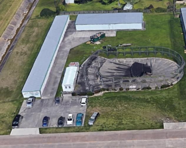
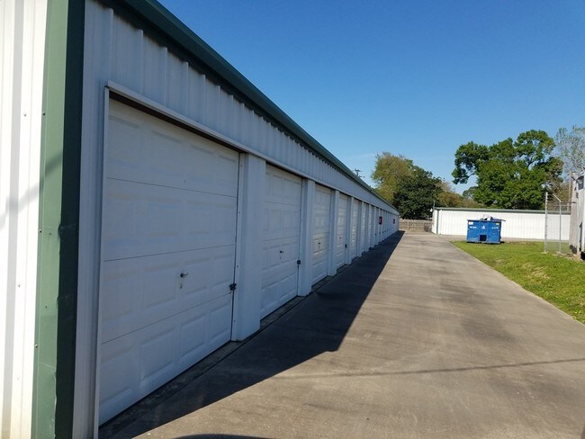
Property Detail
4348 N Link St
Beaumont/Port Arthur
Jefferson
Beaumont-Port Arthur, TX
Texas
049400-000-012900-00100
1.29 AC
Commercialnec
Port Arthur
8,400 SF
NEARBY LISTINGS FOR SALE OR LEASE
DEMOGRAPHICS near 4348 N Link St
1 mile
3 mile
5 mile
2025 Total Population
7,216
54,386
90,775
2030 Population
7,031
53,513
89,910
Pop Growth 2025-2030
(2.56%)
(1.61%)
(0.95%)
Average Age
38
37
38
2025 Total Households
2,731
19,960
34,498
HH Growth 2025-2030
(2.60%)
(1.71%)
(0.99%)
Median Household Inc
$61,319
$56,688
$58,234
Avg Household Size
2.60
2.60
2.60
2025 Avg HH Vehicles
2.00
2.00
2.00
Median Home Value
$165,961
$143,483
$153,129
Median Year Built
1966
1970
1971
Nearby Places
Map Layers
Map Styles
 Street
 Aerial
Layers
 Traffic
 Biking
Places
Listings with unknown addresses are not visible on the map
- Restaurants
- Banks
- Shops
- Fitness
- Groceries
SALE & LEASE HISTORY
LISTING DATE
SALE/LEASE

Apr 09, 2018
For Sale
Nearby Properties
Address
Land Use
TOTAL SIZE
Lot Size
Zoning
Address
Land Use
TOTAL SIZE
Lot Size
Zoning
279,375 SF
18.94 AC
Address
Land Use
TOTAL SIZE
Lot Size
Zoning
235,864 SF
12.21 AC
Address
Land Use
TOTAL SIZE
Lot Size
Zoning
157,411 SF
38.21 AC
Address
Land Use
TOTAL SIZE
Lot Size
Zoning
130,420 SF
6.78 AC
Address
Land Use
TOTAL SIZE
Lot Size
Zoning
47,841 SF
8 AC
Address
Land Use
TOTAL SIZE
Lot Size
Zoning
127,946 SF
7.72 AC
Address
Land Use
TOTAL SIZE
Lot Size
Zoning
79,096 SF
9.09 AC
Address
Land Use
TOTAL SIZE
Lot Size
Zoning
185,832 SF
10.08 AC
Address
Land Use
TOTAL SIZE
Lot Size
Zoning
157,188 SF
8.70 AC
Address
Land Use
TOTAL SIZE
Lot Size
Zoning
97,588 SF
2.81 AC
Address
Land Use
TOTAL SIZE
Lot Size
Zoning
183,963 SF
23.46 AC
Address
Land Use
TOTAL SIZE
Lot Size
Zoning
86,567 SF
5 AC
Address
Land Use
TOTAL SIZE
Lot Size
Zoning
713.58 AC
Address
Land Use
TOTAL SIZE
Lot Size
Zoning
135,891 SF
9.95 AC
Address
Land Use
TOTAL SIZE
Lot Size
Zoning
243,132 SF
21.67 AC
Address
Land Use
TOTAL SIZE
Lot Size
Zoning
155,734 SF
11.27 AC
Address
Land Use
TOTAL SIZE
Lot Size
Zoning
157,343 SF
9.09 AC
Address
Land Use
TOTAL SIZE
Lot Size
Zoning
151,121 SF
9.04 AC
Address
Land Use
TOTAL SIZE
Lot Size
Zoning
81,420 SF
7.16 AC
Address
Land Use
TOTAL SIZE
Lot Size
Zoning
146,251 SF
9.08 AC
Address
Land Use
TOTAL SIZE
Lot Size
Zoning
137,317 SF
3.64 AC
Address
Land Use
TOTAL SIZE
Lot Size
Zoning
108,007 SF
10.49 AC
Address
Land Use
TOTAL SIZE
Lot Size
Zoning
86,911 SF
4.61 AC
Address
Land Use
TOTAL SIZE
Lot Size
Zoning
60,552 SF
15.22 AC
Address
Land Use
TOTAL SIZE
Lot Size
Zoning
39,290 SF
3.21 AC
Address
Land Use
TOTAL SIZE
Lot Size
Zoning
25,199 SF
14.75 AC
Address
Land Use
TOTAL SIZE
Lot Size
Zoning
77,552 SF
23.03 AC
Address
Land Use
TOTAL SIZE
Lot Size
Zoning
20,512 SF
8.58 AC
Address
Land Use
TOTAL SIZE
Lot Size
Zoning
116,500 SF
11.82 AC
Address
Land Use
TOTAL SIZE
Lot Size
Zoning
48,452 SF
4.78 AC
The World's #1 Commercial Real Estate Marketplace
Connect with us
© 2026 CoStar Group
The information above has been obtained from sources believed reliable. While we do not doubt its accuracy we have not verified it and make no guarantee, warranty or representation about it. It is your responsibility to independently confirm its accuracy and completeness. Any projections, opinions, assumptions, or estimates used are for example only and do not represent the current or future performance of the property. The value of this transaction to you depends on tax and other factors which should be evaluated by your tax, financial, and legal advisors. You and your advisors should conduct a careful, independent investigation of the property to determine to your satisfaction the suitability of the property for your needs.