Property Record
43483 Mesa St, Banning, CA 92220

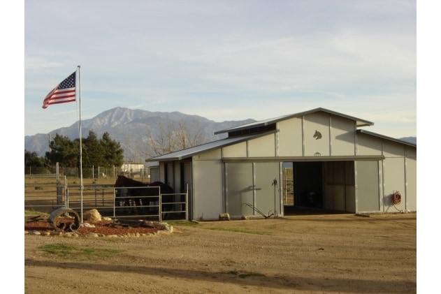
Property Detail
43483 Mesa St
531-050-037
25.88 ACRES M/L IN LOT 65 MB 009/037 BANNING HEIGHTS
Miscellaneous
Riverside
RA
California
B and X Area of moderate flood hazard, usually the area between the limits of the 100-year and 500-year floods.
65
2024
4.68 AC
2025
Beaumont/Hemet
044104
Inland Empire (California)
1,440 SF
Riverside-San Bernardino-Ontario, CA
NEARBY LISTINGS FOR SALE OR LEASE
DEMOGRAPHICS near 43483 Mesa St
1 mile
3 mile
5 mile
2025 Total Population
281
26,761
76,367
2030 Population
286
27,993
78,908
Pop Growth 2025-2030
+ 1.78%
+ 4.60%
+ 3.33%
Average Age
39
39
41
2025 Total Households
88
8,773
25,915
HH Growth 2025-2030
+ 1.14%
+ 4.22%
+ 2.86%
Median Household Inc
$87,500
$70,048
$76,417
Avg Household Size
3.20
3.00
2.80
2025 Avg HH Vehicles
3.00
2.00
2.00
Median Home Value
$440,000
$391,770
$443,934
Median Year Built
1969
1980
1991
Nearby Places
Map Layers
Map Styles
 Street
 Aerial
Layers
 Traffic
 Biking
Places
Listings with unknown addresses are not visible on the map
- Restaurants
- Banks
- Shops
- Fitness
- Groceries
PUBLIC TRANSPORTATION
AIRPORT
Palm Springs International
Drive
Walk
Distance
Palm Springs International
44 min
31.1 mi
Freight Ports
Port of Long Beach
Drive
Walk
Distance
Port of Long Beach
117 min
87.0 mi
SALE & LEASE HISTORY
LISTING DATE
SALE/LEASE

Sep 24, 2016
For Sale
Nearby Properties
Address
Land Use
TOTAL SIZE
Lot Size
Zoning
Address
Land Use
TOTAL SIZE
Lot Size
Zoning
39,250 SF
1.38 AC
C2
Address
Land Use
TOTAL SIZE
Lot Size
Zoning
909 SF
8.17 AC
RA
Address
Land Use
TOTAL SIZE
Lot Size
Zoning
17,272 SF
1.99 AC
Address
Land Use
TOTAL SIZE
Lot Size
Zoning
119,662 SF
6.65 AC
Address
Land Use
TOTAL SIZE
Lot Size
Zoning
119,400 SF
8.21 AC
M
Address
Land Use
TOTAL SIZE
Lot Size
Zoning
27,660 SF
1.13 AC
R3
Address
Land Use
TOTAL SIZE
Lot Size
Zoning
26,916 SF
1.23 AC
R3
Address
Land Use
TOTAL SIZE
Lot Size
Zoning
28,165 SF
2.41 AC
Address
Land Use
TOTAL SIZE
Lot Size
Zoning
102,760 SF
13.29 AC
Address
Land Use
TOTAL SIZE
Lot Size
Zoning
864 SF
4.30 AC
M
Address
Land Use
TOTAL SIZE
Lot Size
Zoning
30,000 SF
2.21 AC
C2
Address
Land Use
TOTAL SIZE
Lot Size
Zoning
31,830 SF
24.18 AC
W2
Address
Land Use
TOTAL SIZE
Lot Size
Zoning
51,600 SF
2.47 AC
M
Address
Land Use
TOTAL SIZE
Lot Size
Zoning
18,461 SF
1.16 AC
R3
Address
Land Use
TOTAL SIZE
Lot Size
Zoning
28,683 SF
5.79 AC
C2
Address
Land Use
TOTAL SIZE
Lot Size
Zoning
14,340 SF
4.70 AC
Address
Land Use
TOTAL SIZE
Lot Size
Zoning
2,783 SF
1.01 AC
Address
Land Use
TOTAL SIZE
Lot Size
Zoning
24,700 SF
2.43 AC
C2
Address
Land Use
TOTAL SIZE
Lot Size
Zoning
17,470 SF
1.45 AC
C2
Address
Land Use
TOTAL SIZE
Lot Size
Zoning
7,524 SF
1 AC
Address
Land Use
TOTAL SIZE
Lot Size
Zoning
16,390 SF
0.79 AC
C2
Address
Land Use
TOTAL SIZE
Lot Size
Zoning
6,320 SF
5.92 AC
Address
Land Use
TOTAL SIZE
Lot Size
Zoning
29,920 SF
2.89 AC
C2
Address
Land Use
TOTAL SIZE
Lot Size
Zoning
26,460 SF
2 AC
M
Address
Land Use
TOTAL SIZE
Lot Size
Zoning
4,001 SF
0.48 AC
CD
Address
Land Use
TOTAL SIZE
Lot Size
Zoning
9,400 SF
1.10 AC
Address
Land Use
TOTAL SIZE
Lot Size
Zoning
8,300 SF
0.79 AC
C2
Address
Land Use
TOTAL SIZE
Lot Size
Zoning
9,000 SF
0.50 AC
C2
Address
Land Use
TOTAL SIZE
Lot Size
Zoning
11,086 SF
1.03 AC
C2
The World's #1 Commercial Real Estate Marketplace
Connect with us
© 2026 CoStar Group
The information above has been obtained from sources believed reliable. While we do not doubt its accuracy we have not verified it and make no guarantee, warranty or representation about it. It is your responsibility to independently confirm its accuracy and completeness. Any projections, opinions, assumptions, or estimates used are for example only and do not represent the current or future performance of the property. The value of this transaction to you depends on tax and other factors which should be evaluated by your tax, financial, and legal advisors. You and your advisors should conduct a careful, independent investigation of the property to determine to your satisfaction the suitability of the property for your needs.