Property Record
435 N Main St, Tarboro, NC 27886
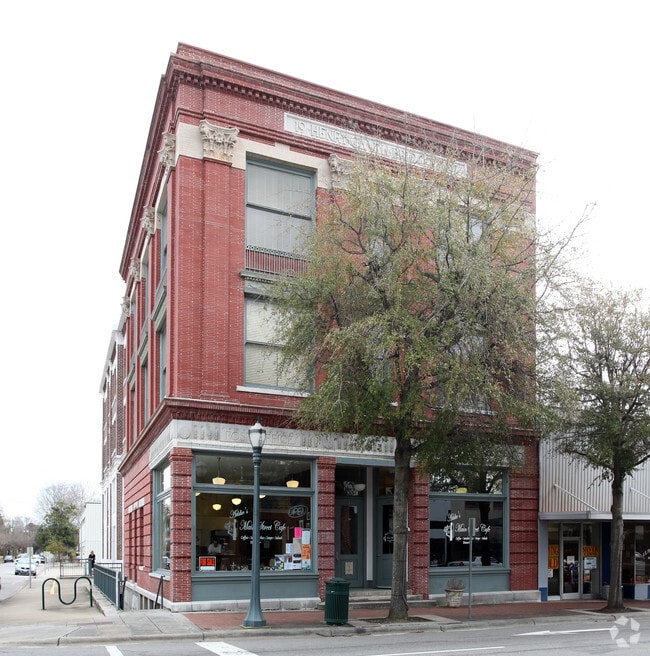
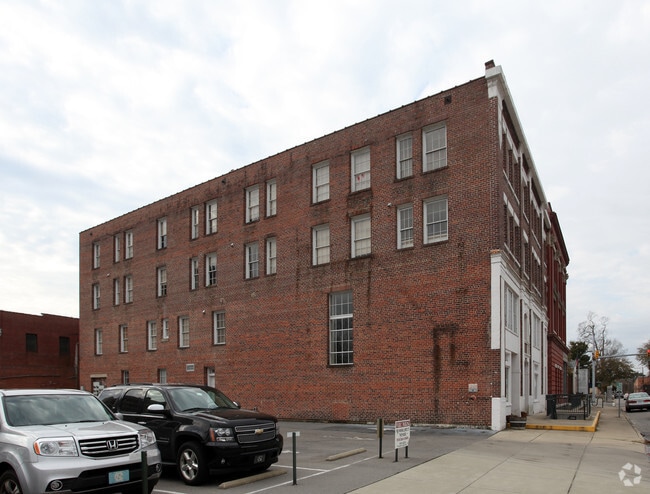
This Property Is For Sale
NEARBY LISTINGS FOR SALE OR LEASE
-
-
View all Tarboro listings for sale on LoopNet.com
Property Detail
435 N Main St
Rocky Mount, NC
W Stamps Howard Jr Trust
4738-35-9036-00
BRIDGERS BUILDING 423-35 MAIN & 105 E CHURCH ST
Commercialnec
Edgecombe
X
North Carolina
3720473800K
0.18 AC
2024
Rocky Mount/Wilson
2024
Other Market Areas
021000
DEMOGRAPHICS near 435 N Main St
1 Mile
3 Mile
5 Mile
2024 Total Population
5,338
13,971
16,162
2029 Population
5,375
13,981
16,107
Pop Growth 2024-2029
+ 0.69%
+ 0.07%
(0.34%)
Average Age
45
44
44
2024 Total Households
2,200
5,844
6,719
HH Growth 2024-2029
+ 1.00%
+ 0.15%
(0.27%)
Median Household Inc
$46,581
$42,396
$44,326
Avg Household Size
2.20
2.30
2.30
2024 Avg HH Vehicles
2.00
2.00
2.00
Median Home Value
$121,123
$128,459
$124,793
Median Year Built
1971
1978
1979
Nearby Places
- Restaurants
- Banks
- Shops
- Fitness
- Groceries
PUBLIC TRANSPORTATION
AIRPORT
Pitt-Greenville
DRIVE
WALK
Distance
Pitt-Greenville
36 min
26.6 mi
Freight Ports
Port of Morehead City
DRIVE
WALK
Distance
Port of Morehead City
163 min
115.9 mi
Nearby Properties
Address
Land Use
TOTAL SIZE
Lot Size
Zoning
Address
Land Use
TOTAL SIZE
Lot Size
Zoning
3,800 SF
18 AC
QI
Address
Land Use
TOTAL SIZE
Lot Size
Zoning
24,680 SF
80.55 AC
Address
Land Use
TOTAL SIZE
Lot Size
Zoning
38,525 SF
52.31 AC
Address
Land Use
TOTAL SIZE
Lot Size
Zoning
73,971 SF
41.80 AC
RA12
Address
Land Use
TOTAL SIZE
Lot Size
Zoning
61,180 SF
9 AC
RA6
Address
Land Use
TOTAL SIZE
Lot Size
Zoning
163,320 SF
57.37 AC
Address
Land Use
TOTAL SIZE
Lot Size
Zoning
239,570 SF
40 AC
Address
Land Use
TOTAL SIZE
Lot Size
Zoning
151,523 SF
16.15 AC
I3
Address
Land Use
TOTAL SIZE
Lot Size
Zoning
176,635 SF
40.99 AC
Address
Land Use
TOTAL SIZE
Lot Size
Zoning
365,173 SF
70.18 AC
Address
Land Use
TOTAL SIZE
Lot Size
Zoning
141,068 SF
7.09 AC
Address
Land Use
TOTAL SIZE
Lot Size
Zoning
39,923 SF
4.96 AC
RA8
Address
Land Use
TOTAL SIZE
Lot Size
Zoning
400 SF
9.63 AC
HDR
Address
Land Use
TOTAL SIZE
Lot Size
Zoning
17,248 SF
13.40 AC
Address
Land Use
TOTAL SIZE
Lot Size
Zoning
77,904 SF
13.33 AC
I3
Address
Land Use
TOTAL SIZE
Lot Size
Zoning
18,900 SF
6.45 AC
I3
Address
Land Use
TOTAL SIZE
Lot Size
Zoning
38,983 SF
5.23 AC
QI
Address
Land Use
TOTAL SIZE
Lot Size
Zoning
236,725 SF
100 AC
Address
Land Use
TOTAL SIZE
Lot Size
Zoning
39,203 SF
4 AC
OI
Address
Land Use
TOTAL SIZE
Lot Size
Zoning
15,101 SF
9.26 AC
RA20
Address
Land Use
TOTAL SIZE
Lot Size
Zoning
13,908 SF
23.73 AC
RA12
Address
Land Use
TOTAL SIZE
Lot Size
Zoning
48,743 SF
20 AC
RA8
Address
Land Use
TOTAL SIZE
Lot Size
Zoning
41,509 SF
5.26 AC
QI
Address
Land Use
TOTAL SIZE
Lot Size
Zoning
32,800 SF
3.44 AC
I3
Address
Land Use
TOTAL SIZE
Lot Size
Zoning
39,931 SF
5.01 AC
OI
Address
Land Use
TOTAL SIZE
Lot Size
Zoning
15,018 SF
1.44 AC
Address
Land Use
TOTAL SIZE
Lot Size
Zoning
3,751 SF
23.88 AC
OI
Address
Land Use
TOTAL SIZE
Lot Size
Zoning
2,492 SF
6.35 AC
RA6
Address
Land Use
TOTAL SIZE
Lot Size
Zoning
52,063 SF
8.96 AC
OI
Address
Land Use
TOTAL SIZE
Lot Size
Zoning
59,360 SF
18.10 AC
The World's #1 Commercial Real Estate Marketplace
Connect with us
© 2025 CoStar Group
The information above has been obtained from sources believed reliable. While we do not doubt its accuracy we have not verified it and make no guarantee, warranty or representation about it. It is your responsibility to independently confirm its accuracy and completeness. Any projections, opinions, assumptions, or estimates used are for example only and do not represent the current or future performance of the property. The value of this transaction to you depends on tax and other factors which should be evaluated by your tax, financial, and legal advisors. You and your advisors should conduct a careful, independent investigation of the property to determine to your satisfaction the suitability of the property for your needs.