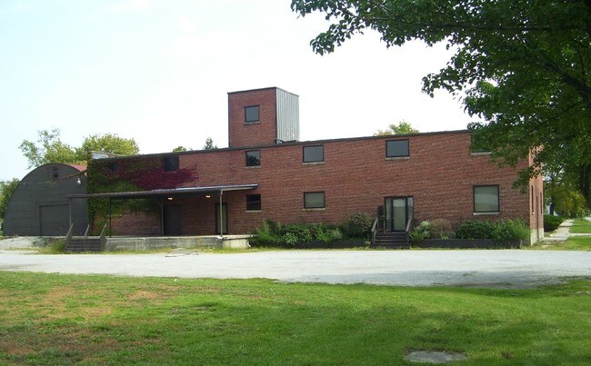
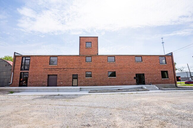
Property Record
435 E Brackenridge St, Fort Wayne, IN 46802
NEARBY LISTINGS FOR SALE OR LEASE
Property Detail
435 E Brackenridge St
Fort Wayne, IN
Lewis Addition
02-12-12-104-019.000-074
LOTS 57 THRU 59 LEWIS ADDITION
Officebuilding
Allen
X
Indiana
18003C0284G
57-59
2023
0.61 AC
2024
Downtown Fort Wayne
001300
Fort Wayne
19,040 SF
DEMOGRAPHICS near 435 E Brackenridge St
1 Mile
3 Mile
5 Mile
2024 Total Population
14,041
103,513
190,818
2029 Population
14,928
108,703
199,463
Pop Growth 2024-2029
+ 6.32%
+ 5.01%
+ 4.53%
Average Age
35
35
37
2024 Total Households
6,145
41,155
77,806
HH Growth 2024-2029
+ 6.82%
+ 5.19%
+ 4.61%
Median Household Inc
$32,822
$42,959
$46,856
Avg Household Size
2.00
2.30
2.30
2024 Avg HH Vehicles
1.00
2.00
2.00
Median Home Value
$110,204
$102,995
$126,132
Median Year Built
1957
1951
1963
Nearby Places
Map Layers
Map Styles
 Street
 Aerial
- Restaurants
- Banks
- Shops
- Fitness
- Groceries
PUBLIC TRANSPORTATION
AIRPORT
Fort Wayne International
DRIVE
WALK
Distance
Fort Wayne International
20 min
10.6 mi
Freight Ports
Port of Toledo
DRIVE
WALK
Distance
Port of Toledo
140 min
104.9 mi
SALE & LEASE HISTORY
LISTING DATE
SALE/LEASE

Sep 24, 2016
For Sale
May 28, 2021
For Lease
Jul 15, 2021
For Sale
Aug 11, 2017
For Sale
Aug 10, 2017
For Sale
Aug 09, 2017
For Sale
Nearby Properties
Address
Land Use
TOTAL SIZE
Lot Size
Zoning
Address
Land Use
TOTAL SIZE
Lot Size
Zoning
460,252 SF
47.79 AC
Address
Land Use
TOTAL SIZE
Lot Size
Zoning
199,723 SF
2.16 AC
Address
Land Use
TOTAL SIZE
Lot Size
Zoning
921,633 SF
18.04 AC
Address
Land Use
TOTAL SIZE
Lot Size
Zoning
725,686 SF
9.45 AC
Address
Land Use
TOTAL SIZE
Lot Size
Zoning
435,615 SF
16.03 AC
Address
Land Use
TOTAL SIZE
Lot Size
Zoning
526,184 SF
35.62 AC
Address
Land Use
TOTAL SIZE
Lot Size
Zoning
348,452 SF
0.80 AC
Address
Land Use
TOTAL SIZE
Lot Size
Zoning
516,460 SF
63.45 AC
Address
Land Use
TOTAL SIZE
Lot Size
Zoning
129,080 SF
15.77 AC
Address
Land Use
TOTAL SIZE
Lot Size
Zoning
126,510 SF
1.30 AC
Address
Land Use
TOTAL SIZE
Lot Size
Zoning
162,471 SF
3.19 AC
Address
Land Use
TOTAL SIZE
Lot Size
Zoning
171,655 SF
0.92 AC
Address
Land Use
TOTAL SIZE
Lot Size
Zoning
82,968 SF
0.74 AC
Address
Land Use
TOTAL SIZE
Lot Size
Zoning
566,867 SF
2.48 AC
Address
Land Use
TOTAL SIZE
Lot Size
Zoning
74,048 SF
1.12 AC
Address
Land Use
TOTAL SIZE
Lot Size
Zoning
353,470 SF
1.08 AC
Address
Land Use
TOTAL SIZE
Lot Size
Zoning
145,274 SF
0.84 AC
Address
Land Use
TOTAL SIZE
Lot Size
Zoning
2.12 AC
Address
Land Use
TOTAL SIZE
Lot Size
Zoning
84,258 SF
0.49 AC
Address
Land Use
TOTAL SIZE
Lot Size
Zoning
171,121 SF
15.40 AC
Address
Land Use
TOTAL SIZE
Lot Size
Zoning
300,402 SF
25.96 AC
Address
Land Use
TOTAL SIZE
Lot Size
Zoning
173,019 SF
2.28 AC
Address
Land Use
TOTAL SIZE
Lot Size
Zoning
171,450 SF
3.29 AC
Address
Land Use
TOTAL SIZE
Lot Size
Zoning
15,182 SF
1 AC
Address
Land Use
TOTAL SIZE
Lot Size
Zoning
177,387 SF
0.75 AC
Address
Land Use
TOTAL SIZE
Lot Size
Zoning
136,270 SF
1.02 AC
Address
Land Use
TOTAL SIZE
Lot Size
Zoning
161,200 SF
8 AC
Address
Land Use
TOTAL SIZE
Lot Size
Zoning
149,627 SF
6.53 AC
Address
Land Use
TOTAL SIZE
Lot Size
Zoning
250,021 SF
2.25 AC
Address
Land Use
TOTAL SIZE
Lot Size
Zoning
139,317 SF
0.57 AC
The World's #1 Commercial Real Estate Marketplace
Connect with us
© 2025 CoStar Group
The information above has been obtained from sources believed reliable. While we do not doubt its accuracy we have not verified it and make no guarantee, warranty or representation about it. It is your responsibility to independently confirm its accuracy and completeness. Any projections, opinions, assumptions, or estimates used are for example only and do not represent the current or future performance of the property. The value of this transaction to you depends on tax and other factors which should be evaluated by your tax, financial, and legal advisors. You and your advisors should conduct a careful, independent investigation of the property to determine to your satisfaction the suitability of the property for your needs.