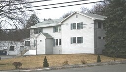
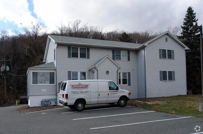
Property Record
435 E Main St, Denville, NJ 07834
NEARBY LISTINGS FOR SALE OR LEASE
Property Detail
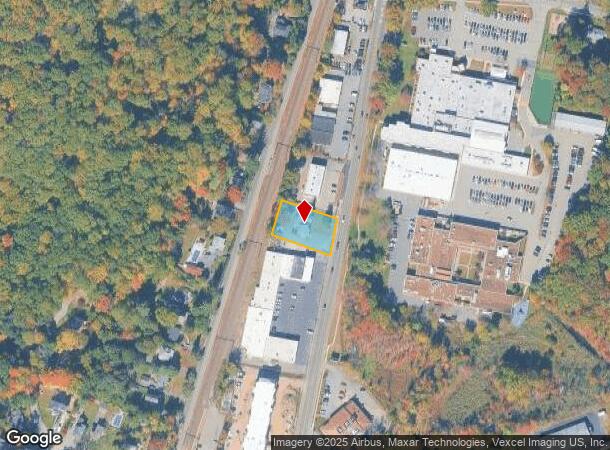
435 E Main St
Newark, NJ-PA
Morris
08-31207-0000-00007
New Jersey
Officebuilding
7
2024
0.48 AC
2025
Western Morris
041500
Northern New Jersey
3,654 SF
DEMOGRAPHICS near 435 E Main St
1 Mile
3 Mile
5 Mile
2024 Total Population
6,534
55,781
165,401
2029 Population
6,515
55,957
165,957
Pop Growth 2024-2029
(0.29%)
+ 0.32%
+ 0.34%
Average Age
42
43
42
2024 Total Households
2,499
20,618
61,107
HH Growth 2024-2029
(0.32%)
+ 0.34%
+ 0.41%
Median Household Inc
$143,969
$130,746
$117,302
Avg Household Size
2.60
2.60
2.60
2024 Avg HH Vehicles
2.00
2.00
2.00
Median Home Value
$441,828
$486,069
$482,215
Median Year Built
1960
1966
1968
Nearby Places
Map Layers
Map Styles
 Street
 Aerial
- Restaurants
- Banks
- Shops
- Fitness
- Groceries
PUBLIC TRANSPORTATION
TRANSIT/SUBWAY
Mount Tabor (Morris & Essex Morristown Line - NJ Transit Commuter Rail (NJ Transit))
DRIVE
WALK
Distance
Mount Tabor (Morris & Essex Morristown Line - NJ Transit Commuter Rail (NJ Transit))
1 min
7 min
0.3 mi
Denville (Montclair-Boonton Line - NJ Transit Commuter Rail (NJ Transit), Morris & Essex Morristown Line - NJ Transit Commuter Rail (NJ Transit))
DRIVE
WALK
Distance
Denville (Montclair-Boonton Line - NJ Transit Commuter Rail (NJ Transit), Morris & Essex Morristown Line - NJ Transit Commuter Rail (NJ Transit))
2 min
10 min
0.5 mi
COMMUTER RAIL
Mount Tabor (Morris & Essex Morristown Line - NJ Transit Commuter Rail (NJ Transit))
DRIVE
WALK
Distance
Mount Tabor (Morris & Essex Morristown Line - NJ Transit Commuter Rail (NJ Transit))
1 min
8 min
0.3 mi
Denville (Montclair-Boonton Line - NJ Transit Commuter Rail (NJ Transit), Morris & Essex Morristown Line - NJ Transit Commuter Rail (NJ Transit))
DRIVE
WALK
Distance
Denville (Montclair-Boonton Line - NJ Transit Commuter Rail (NJ Transit), Morris & Essex Morristown Line - NJ Transit Commuter Rail (NJ Transit))
2 min
10 min
0.5 mi
AIRPORT
Newark Liberty International
DRIVE
WALK
Distance
Newark Liberty International
35 min
26.9 mi
LaGuardia
DRIVE
WALK
Distance
LaGuardia
59 min
44.1 mi
Freight Ports
Maher Terminal
DRIVE
WALK
Distance
Maher Terminal
40 min
28.0 mi
Nearby Properties
Address
Land Use
TOTAL SIZE
Lot Size
Zoning
Address
Land Use
TOTAL SIZE
Lot Size
Zoning
428,141 SF
12.30 AC
OB-3
Address
Land Use
TOTAL SIZE
Lot Size
Zoning
114,267 SF
27.26 AC
SED5
Address
Land Use
TOTAL SIZE
Lot Size
Zoning
257,220 SF
30.83 AC
SED5
Address
Land Use
TOTAL SIZE
Lot Size
Zoning
38.86 AC
L
Address
Land Use
TOTAL SIZE
Lot Size
Zoning
32 AC
R-1M
Address
Land Use
TOTAL SIZE
Lot Size
Zoning
88,345 SF
15.67 AC
R-7
Address
Land Use
TOTAL SIZE
Lot Size
Zoning
377,114 SF
40.64 AC
SD10
Address
Land Use
TOTAL SIZE
Lot Size
Zoning
Address
Land Use
TOTAL SIZE
Lot Size
Zoning
203,590 SF
24.98 AC
SD10
Address
Land Use
TOTAL SIZE
Lot Size
Zoning
26,967 SF
14.06 AC
OB-4
Address
Land Use
TOTAL SIZE
Lot Size
Zoning
22.85 AC
B-3
Address
Land Use
TOTAL SIZE
Lot Size
Zoning
156,564 SF
19.66 AC
B-2
Address
Land Use
TOTAL SIZE
Lot Size
Zoning
16.01 AC
R-C
Address
Land Use
TOTAL SIZE
Lot Size
Zoning
11.90 AC
OB3
Address
Land Use
TOTAL SIZE
Lot Size
Zoning
1,440 SF
38.80 AC
I-2
Address
Land Use
TOTAL SIZE
Lot Size
Zoning
28.84 AC
OBDS
Address
Land Use
TOTAL SIZE
Lot Size
Zoning
333,991 SF
15.76 AC
SD10
Address
Land Use
TOTAL SIZE
Lot Size
Zoning
270,140 SF
51.78 AC
R-1B
Address
Land Use
TOTAL SIZE
Lot Size
Zoning
23.01 AC
SD10
Address
Land Use
TOTAL SIZE
Lot Size
Zoning
217,502 SF
25 AC
SED5
Address
Land Use
TOTAL SIZE
Lot Size
Zoning
Address
Land Use
TOTAL SIZE
Lot Size
Zoning
26.65 AC
AHD7
Address
Land Use
TOTAL SIZE
Lot Size
Zoning
180,636 SF
65.98 AC
I
Address
Land Use
TOTAL SIZE
Lot Size
Zoning
405,000 SF
19.06 AC
ROL
Address
Land Use
TOTAL SIZE
Lot Size
Zoning
156,380 SF
9.72 AC
I
Address
Land Use
TOTAL SIZE
Lot Size
Zoning
17.33 AC
R-5
Address
Land Use
TOTAL SIZE
Lot Size
Zoning
5.87 AC
OL-2
Address
Land Use
TOTAL SIZE
Lot Size
Zoning
13.56 AC
L
Address
Land Use
TOTAL SIZE
Lot Size
Zoning
38.15 AC
R-1
Address
Land Use
TOTAL SIZE
Lot Size
Zoning
268,584 SF
13.67 AC
ROL
The World's #1 Commercial Real Estate Marketplace
Connect with us
© 2025 CoStar Group
The information above has been obtained from sources believed reliable. While we do not doubt its accuracy we have not verified it and make no guarantee, warranty or representation about it. It is your responsibility to independently confirm its accuracy and completeness. Any projections, opinions, assumptions, or estimates used are for example only and do not represent the current or future performance of the property. The value of this transaction to you depends on tax and other factors which should be evaluated by your tax, financial, and legal advisors. You and your advisors should conduct a careful, independent investigation of the property to determine to your satisfaction the suitability of the property for your needs.