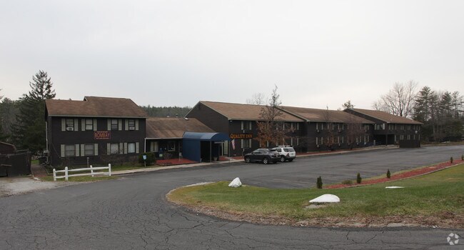
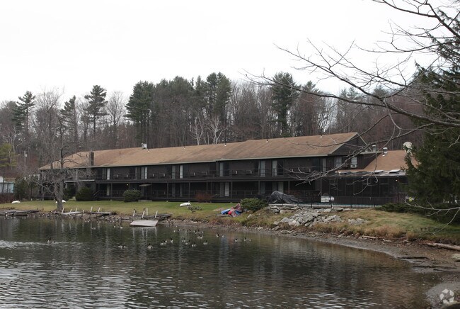
Property Record
435 Laurel St, Lee, MA 01238

Property Detail
435 Laurel St
LEEE-000007-000000-000000-000200-000200
Berkshire
Motel
Massachusetts
RB
0-20.0
2025
1.80 AC
2025
Massachusetts North/West Area
914100
Other Market Areas
27,078 SF
Pittsfield, MA
NEARBY LISTINGS FOR SALE OR LEASE
DEMOGRAPHICS near 435 Laurel St
1 mile
3 mile
5 mile
2025 Total Population
1,466
9,044
12,677
2030 Population
1,479
9,075
12,726
Pop Growth 2025-2030
+ 0.89%
+ 0.34%
+ 0.39%
Average Age
50
50
51
2025 Total Households
648
4,204
5,843
HH Growth 2025-2030
+ 0.77%
+ 0.43%
+ 0.43%
Median Household Inc
$73,663
$83,104
$86,810
Avg Household Size
2.00
2.00
2.00
2025 Avg HH Vehicles
2.00
2.00
2.00
Median Home Value
$380,582
$398,083
$428,756
Median Year Built
1973
1960
1960
Nearby Places
Map Layers
Map Styles
 Street
 Aerial
Layers
 Traffic
 Biking
Places
Listings with unknown addresses are not visible on the map
- Restaurants
- Banks
- Shops
- Fitness
- Groceries
PUBLIC TRANSPORTATION
COMMUTER RAIL
Pittsfield Amtrak Station (Empire Service - Amtrak, Lake Shore Limited - Amtrak)
Drive
Walk
Distance
Pittsfield Amtrak Station (Empire Service - Amtrak, Lake Shore Limited - Amtrak)
17 min
9.6 mi
Freight Ports
Albany, NY Port
Drive
Walk
Distance
Albany, NY Port
59 min
46.3 mi
Nearby Properties
Address
Land Use
TOTAL SIZE
Lot Size
Zoning
Address
Land Use
TOTAL SIZE
Lot Size
Zoning
199,132 SF
35 AC
R20
Address
Land Use
TOTAL SIZE
Lot Size
Zoning
27,163 SF
43.27 AC
R-1A
Address
Land Use
TOTAL SIZE
Lot Size
Zoning
235,290 SF
106.98 AC
PCVC
Address
Land Use
TOTAL SIZE
Lot Size
Zoning
91.73 AC
R-1A
Address
Land Use
TOTAL SIZE
Lot Size
Zoning
60.39 AC
R-1A
Address
Land Use
TOTAL SIZE
Lot Size
Zoning
29.60 AC
R-1A
Address
Land Use
TOTAL SIZE
Lot Size
Zoning
99.10 AC
R4
Address
Land Use
TOTAL SIZE
Lot Size
Zoning
87.50 AC
R-1A
Address
Land Use
TOTAL SIZE
Lot Size
Zoning
19,286 SF
32.70 AC
R-1A
Address
Land Use
TOTAL SIZE
Lot Size
Zoning
61,851 SF
13.20 AC
RB
Address
Land Use
TOTAL SIZE
Lot Size
Zoning
86 AC
R4
Address
Land Use
TOTAL SIZE
Lot Size
Zoning
30,003 SF
56 AC
R-1A
Address
Land Use
TOTAL SIZE
Lot Size
Zoning
12.16 AC
R-1A
Address
Land Use
TOTAL SIZE
Lot Size
Zoning
52,336 SF
9.63 AC
CBC
Address
Land Use
TOTAL SIZE
Lot Size
Zoning
1.90 AC
COMMER
Address
Land Use
TOTAL SIZE
Lot Size
Zoning
54,323 SF
3.50 AC
R20
Address
Land Use
TOTAL SIZE
Lot Size
Zoning
48 AC
R-1A
Address
Land Use
TOTAL SIZE
Lot Size
Zoning
49,256 SF
7 AC
RA40
Address
Land Use
TOTAL SIZE
Lot Size
Zoning
12.76 AC
R-1A
Address
Land Use
TOTAL SIZE
Lot Size
Zoning
70,278 SF
5.23 AC
CR
Address
Land Use
TOTAL SIZE
Lot Size
Zoning
66,701 SF
15.96 AC
I
Address
Land Use
TOTAL SIZE
Lot Size
Zoning
8,088 SF
41.90 AC
R4
Address
Land Use
TOTAL SIZE
Lot Size
Zoning
7.60 AC
R-1A
Address
Land Use
TOTAL SIZE
Lot Size
Zoning
3,808 SF
1.87 AC
DCBC
Address
Land Use
TOTAL SIZE
Lot Size
Zoning
96,152 SF
13.25 AC
OPLI
Address
Land Use
TOTAL SIZE
Lot Size
Zoning
112,374 SF
19.30 AC
INDUST
Address
Land Use
TOTAL SIZE
Lot Size
Zoning
19,364 SF
21.25 AC
R4
Address
Land Use
TOTAL SIZE
Lot Size
Zoning
192,156 SF
37.82 AC
I
Address
Land Use
TOTAL SIZE
Lot Size
Zoning
4,749 SF
13.70 AC
R4
Address
Land Use
TOTAL SIZE
Lot Size
Zoning
116,000 SF
39 AC
I
The World's #1 Commercial Real Estate Marketplace
Connect with us
© 2026 CoStar Group
The information above has been obtained from sources believed reliable. While we do not doubt its accuracy we have not verified it and make no guarantee, warranty or representation about it. It is your responsibility to independently confirm its accuracy and completeness. Any projections, opinions, assumptions, or estimates used are for example only and do not represent the current or future performance of the property. The value of this transaction to you depends on tax and other factors which should be evaluated by your tax, financial, and legal advisors. You and your advisors should conduct a careful, independent investigation of the property to determine to your satisfaction the suitability of the property for your needs.