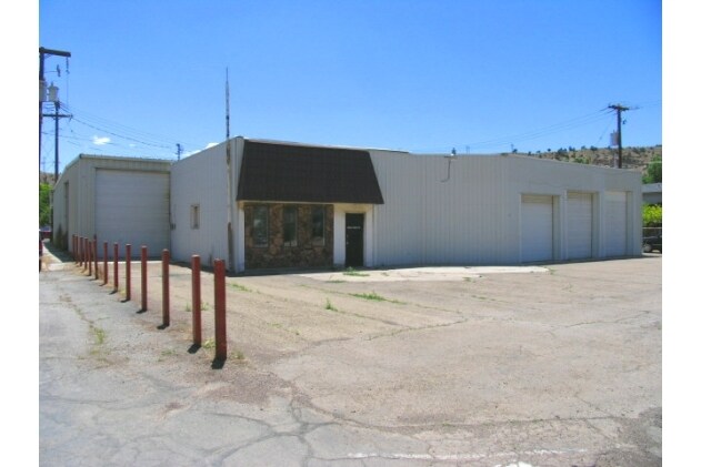
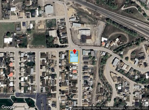
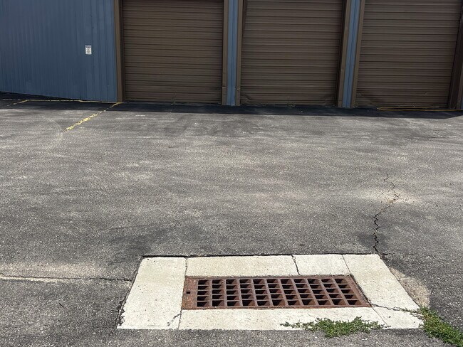
Property Record
435 N Main St, Helper, UT 84526
NEARBY LISTINGS FOR SALE OR LEASE
-
-
View all Helper listings for sale on LoopNet.com
Property Detail
435 N Main St
Price, UT
Bryner Sub
1A-1006-0000
ALL OF LOTS 92 94 96 98 100 & 102 BLOCK 2 BRYNER SUBDIVISION TO CITY OF HELPER. ALSO E 6 FT OF VACATED ALLEY. (.01) 0.35 AC
Realpropertynec
Carbon
X
Utah
49007C0378E
92-100
2025
0.35 AC
2025
Utah North Area
000500
Other Market Areas
8,859 SF
DEMOGRAPHICS near 435 N Main St
1 Mile
3 Mile
5 Mile
2024 Total Population
2,337
3,437
4,499
2029 Population
2,478
3,609
4,755
Pop Growth 2024-2029
+ 6.03%
+ 5.00%
+ 5.69%
Average Age
41
41
41
2024 Total Households
979
1,420
1,844
HH Growth 2024-2029
+ 5.82%
+ 4.86%
+ 5.59%
Median Household Inc
$56,451
$57,096
$60,353
Avg Household Size
2.40
2.40
2.50
2024 Avg HH Vehicles
2.00
2.00
2.00
Median Home Value
$147,155
$151,832
$159,105
Median Year Built
1949
1949
1956
Nearby Places
Map Layers
Map Styles
 Street
 Aerial
- Restaurants
- Banks
- Shops
- Fitness
- Groceries
PUBLIC TRANSPORTATION
COMMUTER RAIL
Helper Amtrak Station (California Zephyr - Amtrak)
DRIVE
WALK
Distance
Helper Amtrak Station (California Zephyr - Amtrak)
2 min
17 min
0.9 mi
Freight Ports
Port of Stockton
DRIVE
WALK
Distance
Port of Stockton
835 min
805.1 mi
SALE & LEASE HISTORY
LISTING DATE
SALE/LEASE

Sep 06, 2024
For Sale
Nearby Properties
Address
Land Use
TOTAL SIZE
Lot Size
Zoning
Address
Land Use
TOTAL SIZE
Lot Size
Zoning
3,919 SF
5.91 AC
Address
Land Use
TOTAL SIZE
Lot Size
Zoning
4.10 AC
Address
Land Use
TOTAL SIZE
Lot Size
Zoning
41,965 SF
3.12 AC
Address
Land Use
TOTAL SIZE
Lot Size
Zoning
1,032 SF
2.13 AC
Address
Land Use
TOTAL SIZE
Lot Size
Zoning
159.41 AC
Address
Land Use
TOTAL SIZE
Lot Size
Zoning
12,000 SF
4.82 AC
Address
Land Use
TOTAL SIZE
Lot Size
Zoning
4,257 SF
2.75 AC
Address
Land Use
TOTAL SIZE
Lot Size
Zoning
3,592 SF
0.12 AC
Address
Land Use
TOTAL SIZE
Lot Size
Zoning
16,720 SF
117.26 AC
Address
Land Use
TOTAL SIZE
Lot Size
Zoning
Address
Land Use
TOTAL SIZE
Lot Size
Zoning
8,505 SF
1.36 AC
Address
Land Use
TOTAL SIZE
Lot Size
Zoning
2,800 SF
0.24 AC
Address
Land Use
TOTAL SIZE
Lot Size
Zoning
2,976 SF
0.08 AC
Address
Land Use
TOTAL SIZE
Lot Size
Zoning
Address
Land Use
TOTAL SIZE
Lot Size
Zoning
732 SF
5 AC
Address
Land Use
TOTAL SIZE
Lot Size
Zoning
Address
Land Use
TOTAL SIZE
Lot Size
Zoning
5,562 SF
3.44 AC
Address
Land Use
TOTAL SIZE
Lot Size
Zoning
5,260 SF
13.39 AC
Address
Land Use
TOTAL SIZE
Lot Size
Zoning
4,374 SF
5 AC
Address
Land Use
TOTAL SIZE
Lot Size
Zoning
3,023 SF
6.40 AC
Address
Land Use
TOTAL SIZE
Lot Size
Zoning
10,020 SF
2 AC
Address
Land Use
TOTAL SIZE
Lot Size
Zoning
3,788 SF
1.03 AC
Address
Land Use
TOTAL SIZE
Lot Size
Zoning
864 SF
0.47 AC
Address
Land Use
TOTAL SIZE
Lot Size
Zoning
3,594 SF
0.83 AC
Address
Land Use
TOTAL SIZE
Lot Size
Zoning
9,200 SF
4.12 AC
Address
Land Use
TOTAL SIZE
Lot Size
Zoning
1.50 AC
Address
Land Use
TOTAL SIZE
Lot Size
Zoning
5,092 SF
2.08 AC
Address
Land Use
TOTAL SIZE
Lot Size
Zoning
11,139 SF
0.16 AC
Address
Land Use
TOTAL SIZE
Lot Size
Zoning
2,292 SF
6.40 AC
Address
Land Use
TOTAL SIZE
Lot Size
Zoning
3,182 SF
0.21 AC
The World's #1 Commercial Real Estate Marketplace
Connect with us
© 2025 CoStar Group
The information above has been obtained from sources believed reliable. While we do not doubt its accuracy we have not verified it and make no guarantee, warranty or representation about it. It is your responsibility to independently confirm its accuracy and completeness. Any projections, opinions, assumptions, or estimates used are for example only and do not represent the current or future performance of the property. The value of this transaction to you depends on tax and other factors which should be evaluated by your tax, financial, and legal advisors. You and your advisors should conduct a careful, independent investigation of the property to determine to your satisfaction the suitability of the property for your needs.