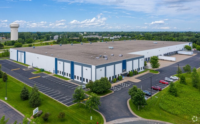
Property Record
435 Park Ct, Circle Pines, MN 55014


Save to a Folder
{{folder.Name}}
{{folder.ListingIds.length}} Properties
{{folder.ListingIds.length}} Property
Create a New Folder
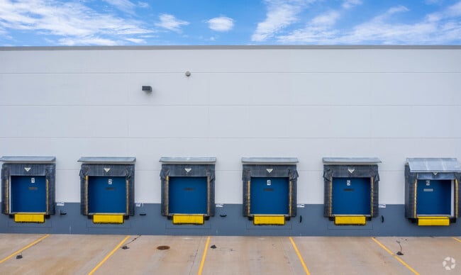
Property Detail
435 Park Ct
Minneapolis-St. Paul-Bloomington, MN-WI
LOT 2 BLK 1 MARSHAN LAKE INDUSTRIAL PARK, SUBJ TO EASE OFREC
17-31-22-23-0022
ANOKA
Industrialgeneral
Minnesota
A Areas with a 1% annual chance of flooding and a 26% chance of flooding over the life of a 30-year mortgage.
2
2026
0.13 AC
2026
North Central
050229
Minneapolis/St Paul
265,400 SF
NEARBY LISTINGS FOR SALE OR LEASE
DEMOGRAPHICS near 435 Park Ct
1 mile
3 mile
5 mile
2025 Total Population
4,077
27,344
77,753
2030 Population
4,172
28,298
80,479
Pop Growth 2025-2030
+ 2.33%
+ 3.49%
+ 3.51%
Average Age
41
40
40
2025 Total Households
1,176
9,219
27,215
HH Growth 2025-2030
+ 2.98%
+ 3.55%
+ 3.48%
Median Household Inc
$81,870
$113,281
$122,521
Avg Household Size
2.60
2.80
2.80
2025 Avg HH Vehicles
2.00
2.00
2.00
Median Home Value
$353,700
$383,766
$416,371
Median Year Built
1991
1989
1995
Nearby Places
Map Layers
Map Styles
 Street
 Aerial
Layers
 Traffic
 Biking
Places
Listings with unknown addresses are not visible on the map
- Restaurants
- Banks
- Shops
- Fitness
- Groceries
PUBLIC TRANSPORTATION
AIRPORT
Minneapolis-St Paul International/Wold-Chamberlain
Drive
Walk
Distance
Minneapolis-St Paul International/Wold-Chamberlain
41 min
28.0 mi
Freight Ports
Port Milwaukee
Drive
Walk
Distance
Port Milwaukee
387 min
350.1 mi
SALE & LEASE HISTORY
LISTING DATE
SALE/LEASE

Jun 16, 2017
For Lease
Nearby Properties
Address
Land Use
TOTAL SIZE
Lot Size
Zoning
Address
Land Use
TOTAL SIZE
Lot Size
Zoning
226,201 SF
0.70 AC
Address
Land Use
TOTAL SIZE
Lot Size
Zoning
156,499 SF
0.80 AC
Address
Land Use
TOTAL SIZE
Lot Size
Zoning
239,389 SF
5.73 AC
Address
Land Use
TOTAL SIZE
Lot Size
Zoning
Address
Land Use
TOTAL SIZE
Lot Size
Zoning
4 SF
3.20 AC
Address
Land Use
TOTAL SIZE
Lot Size
Zoning
152,721 SF
Address
Land Use
TOTAL SIZE
Lot Size
Zoning
74,366 SF
10 AC
Address
Land Use
TOTAL SIZE
Lot Size
Zoning
46,557 SF
0.90 AC
Address
Land Use
TOTAL SIZE
Lot Size
Zoning
190,377 SF
0.90 AC
Address
Land Use
TOTAL SIZE
Lot Size
Zoning
223,763 SF
24.89 AC
Address
Land Use
TOTAL SIZE
Lot Size
Zoning
48,260 SF
10.38 AC
Address
Land Use
TOTAL SIZE
Lot Size
Zoning
180,712 SF
15.95 AC
Address
Land Use
TOTAL SIZE
Lot Size
Zoning
43,132 SF
37.89 AC
Address
Land Use
TOTAL SIZE
Lot Size
Zoning
52,981 SF
5.27 AC
Address
Land Use
TOTAL SIZE
Lot Size
Zoning
185,498 SF
25.01 AC
Address
Land Use
TOTAL SIZE
Lot Size
Zoning
32,314 SF
0.40 AC
Address
Land Use
TOTAL SIZE
Lot Size
Zoning
235,504 SF
30.54 AC
Address
Land Use
TOTAL SIZE
Lot Size
Zoning
243,028 SF
24.35 AC
Address
Land Use
TOTAL SIZE
Lot Size
Zoning
87,740 SF
0.60 AC
Address
Land Use
TOTAL SIZE
Lot Size
Zoning
91,397 SF
0.60 AC
Address
Land Use
TOTAL SIZE
Lot Size
Zoning
87,320 SF
0.80 AC
Address
Land Use
TOTAL SIZE
Lot Size
Zoning
1 SF
0.24 AC
Address
Land Use
TOTAL SIZE
Lot Size
Zoning
109,470 SF
12.67 AC
Address
Land Use
TOTAL SIZE
Lot Size
Zoning
120,680 SF
0.11 AC
Address
Land Use
TOTAL SIZE
Lot Size
Zoning
79,827 SF
2.81 AC
Address
Land Use
TOTAL SIZE
Lot Size
Zoning
40,983 SF
Address
Land Use
TOTAL SIZE
Lot Size
Zoning
6,316 SF
28.25 AC
Address
Land Use
TOTAL SIZE
Lot Size
Zoning
Address
Land Use
TOTAL SIZE
Lot Size
Zoning
67,688 SF
40 AC
The World's #1 Commercial Real Estate Marketplace
Connect with us
© 2026 CoStar Group
The information above has been obtained from sources believed reliable. While we do not doubt its accuracy we have not verified it and make no guarantee, warranty or representation about it. It is your responsibility to independently confirm its accuracy and completeness. Any projections, opinions, assumptions, or estimates used are for example only and do not represent the current or future performance of the property. The value of this transaction to you depends on tax and other factors which should be evaluated by your tax, financial, and legal advisors. You and your advisors should conduct a careful, independent investigation of the property to determine to your satisfaction the suitability of the property for your needs.