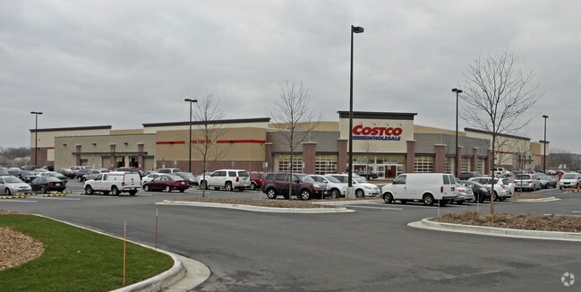
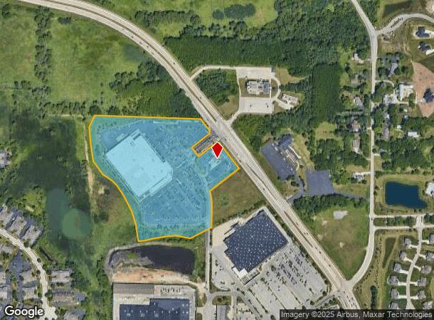
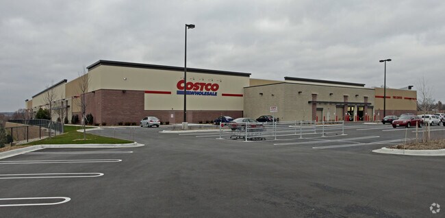
Property Record
435 Pewaukee Rd, Pewaukee, WI 53072
NEARBY LISTINGS FOR SALE OR LEASE
Property Detail
435 Pewaukee Rd
Milwaukee-Waukesha-West Allis, WI
LOT 11 CERT SURV 10866 VOL 105/246 PT SW1/4 SEC 3 & PT NE1/4 & NW1/4 SEC 10 T7N R19E DOC# 3835666
PWV-0901-990-009
Waukesha
Commercialnec
Wisconsin
AE
11
55133C0203H
18.57 AC
2024
Central Waukesha
2024
Milwaukee/Madison
203304
DEMOGRAPHICS near 435 Pewaukee Rd
1 Mile
3 Mile
5 Mile
2024 Total Population
5,459
23,254
80,099
2029 Population
5,572
23,553
82,022
Pop Growth 2024-2029
+ 2.07%
+ 1.29%
+ 2.40%
Average Age
42
43
42
2024 Total Households
2,428
9,997
32,800
HH Growth 2024-2029
+ 2.22%
+ 1.29%
+ 2.36%
Median Household Inc
$86,515
$90,378
$91,087
Avg Household Size
2.20
2.30
2.40
2024 Avg HH Vehicles
2.00
2.00
2.00
Median Home Value
$360,911
$347,052
$345,776
Median Year Built
1992
1989
1985
Nearby Places
Map Layers
Map Styles
 Street
 Aerial
- Restaurants
- Banks
- Shops
- Fitness
- Groceries
PUBLIC TRANSPORTATION
AIRPORT
General Mitchell International
DRIVE
WALK
Distance
General Mitchell International
40 min
25.0 mi
Freight Ports
Port Milwaukee
DRIVE
WALK
Distance
Port Milwaukee
32 min
21.6 mi
Nearby Properties
Address
Land Use
TOTAL SIZE
Lot Size
Zoning
Address
Land Use
TOTAL SIZE
Lot Size
Zoning
25.92 AC
Address
Land Use
TOTAL SIZE
Lot Size
Zoning
Address
Land Use
TOTAL SIZE
Lot Size
Zoning
Address
Land Use
TOTAL SIZE
Lot Size
Zoning
Address
Land Use
TOTAL SIZE
Lot Size
Zoning
Address
Land Use
TOTAL SIZE
Lot Size
Zoning
24.03 AC
Address
Land Use
TOTAL SIZE
Lot Size
Zoning
20.65 AC
Address
Land Use
TOTAL SIZE
Lot Size
Zoning
Address
Land Use
TOTAL SIZE
Lot Size
Zoning
13.99 AC
Address
Land Use
TOTAL SIZE
Lot Size
Zoning
12.28 AC
Address
Land Use
TOTAL SIZE
Lot Size
Zoning
136.33 AC
M-2
Address
Land Use
TOTAL SIZE
Lot Size
Zoning
Address
Land Use
TOTAL SIZE
Lot Size
Zoning
16.04 AC
Address
Land Use
TOTAL SIZE
Lot Size
Zoning
5.23 AC
Address
Land Use
TOTAL SIZE
Lot Size
Zoning
Address
Land Use
TOTAL SIZE
Lot Size
Zoning
16.47 AC
Address
Land Use
TOTAL SIZE
Lot Size
Zoning
11.92 AC
Address
Land Use
TOTAL SIZE
Lot Size
Zoning
15.45 AC
Address
Land Use
TOTAL SIZE
Lot Size
Zoning
11.02 AC
Address
Land Use
TOTAL SIZE
Lot Size
Zoning
Address
Land Use
TOTAL SIZE
Lot Size
Zoning
Address
Land Use
TOTAL SIZE
Lot Size
Zoning
5.01 AC
Address
Land Use
TOTAL SIZE
Lot Size
Zoning
11.96 AC
Address
Land Use
TOTAL SIZE
Lot Size
Zoning
13.88 AC
Address
Land Use
TOTAL SIZE
Lot Size
Zoning
Address
Land Use
TOTAL SIZE
Lot Size
Zoning
Address
Land Use
TOTAL SIZE
Lot Size
Zoning
Address
Land Use
TOTAL SIZE
Lot Size
Zoning
Address
Land Use
TOTAL SIZE
Lot Size
Zoning
11.30 AC
The World's #1 Commercial Real Estate Marketplace
Connect with us
© 2025 CoStar Group
The information above has been obtained from sources believed reliable. While we do not doubt its accuracy we have not verified it and make no guarantee, warranty or representation about it. It is your responsibility to independently confirm its accuracy and completeness. Any projections, opinions, assumptions, or estimates used are for example only and do not represent the current or future performance of the property. The value of this transaction to you depends on tax and other factors which should be evaluated by your tax, financial, and legal advisors. You and your advisors should conduct a careful, independent investigation of the property to determine to your satisfaction the suitability of the property for your needs.